![](/images/other/stat-length.png)
Lerné La devinière
Gîte Pic Epeiche
Benutzer
![Länge](/images/other/stat-length.png)
Länge
14 km
![Maximale Höhe](https://static1.geolcdn.com/siteimages/upload/files/1508320355ic_sort_altitude_max_24dp.png)
Maximale Höhe
116 m
![Positive Höhendifferenz](https://static1.geolcdn.com/siteimages/upload/files/1508320355ic_sort_den_pos_24dp.png)
Positive Höhendifferenz
150 m
![Km-Effort](/images/other/stat-length.png)
Km-Effort
16 km
![Min. Höhe](https://static1.geolcdn.com/siteimages/upload/files/1508320355ic_sort_altitude_min_24dp.png)
Min. Höhe
56 m
![Negative Höhendifferenz](https://static1.geolcdn.com/siteimages/upload/files/1508320355ic_sort_den_neg_24dp.png)
Negative Höhendifferenz
150 m
![Boucle](https://static1.geolcdn.com/siteimages/upload/files/16400158638029165_repeat_loop_refresh_sync_direction_icon.png)
Boucle
Ja
Erstellungsdatum :
2021-11-05 14:21:21.796
Letzte Änderung :
2021-11-05 14:31:09.438
![Wandern](https://static1.geolcdn.com/sitytour/trail-icons/101.png)
3h37
Schwierigkeit : Schwierig
![Scannen Sie diesen QR-Code, um die Tour in der SityTrail-Anwendung zu öffnen](https://capi.geolives.com/qq0zvz2zws4bq2lad0pu/sitytour/trails/2993229/qr.png?size=200)
Kostenlosegpshiking-Anwendung
Über SityTrail
Tour Wandern von 14 km verfügbar auf Zentrum-Loiretal, Indre-et-Loire, Lerné. Diese Tour wird von Gîte Pic Epeiche vorgeschlagen.
Beschreibung
Départ du Gîte Pic Epeiche, ballade en forêt au dessus de Lerné puis sur les plateaux au dessus de Seuilly pour arrivée à la Devinière, Maison natale de Rabelais, retour par le Coteaux de Seuilly et par le bourg de lerné
Ort
Land:
France
Region :
Zentrum-Loiretal
Abteilung/Provinz :
Indre-et-Loire
Kommune :
Lerné
Standort:
Unknown
Gehen Sie:(Dec)
Gehen Sie:(UTM)
281008 ; 5224525 (31T) N.
Kommentare
Touren in der Umgebung
![Tour Wandern Fontevraud-l'Abbaye - Fontevraud - Photo](https://media.geolcdn.com/t/375/260/0f1eef32-23a6-4b62-be59-e0e45f8d97da.jpg&format=jpg&maxdim=2)
![Wandern Wandern](https://static1.geolcdn.com/sitytour/trail-icons/101.png)
Fontevraud
Wandern
Schwierig
Fontevraud-l'Abbaye,
Pays de la Loire,
Maine-et-Loire,
France
![](/images/other/stat-length.png)
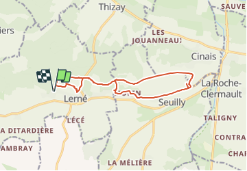
17,1 km | 21 km-effort
2h 55min
![](https://static1.geolcdn.com/siteimages/upload/files/16400158638029165_repeat_loop_refresh_sync_direction_icon.png)
Ja
![Tour Wandern Saint-Germain-sur-Vienne - St-Germain-sur-Vienne - 20.3km 280m 4h30 - 2018 05 06 - Photo](https://media.geolcdn.com/t/375/260/ext.jpg?maxdim=2&url=https%3A%2F%2Fstatic1.geolcdn.com%2Fsiteimages%2Fupload%2Ffiles%2F1553511878bg_sport_marche.png)
![Wandern Wandern](https://static1.geolcdn.com/sitytour/trail-icons/101.png)
St-Germain-sur-Vienne - 20.3km 280m 4h30 - 2018 05 06
Wandern
Einfach
Saint-Germain-sur-Vienne,
Zentrum-Loiretal,
Indre-et-Loire,
France
![](/images/other/stat-length.png)
20 km | 24 km-effort
4h 30min
![](https://static1.geolcdn.com/siteimages/upload/files/16400158638029165_repeat_loop_refresh_sync_direction_icon.png)
Ja
![Tour Wandern Fontevraud-l'Abbaye - Tracé_23-JUIN-23 125458 - Photo](https://media.geolcdn.com/t/375/260/ext.jpg?maxdim=2&url=https%3A%2F%2Fstatic1.geolcdn.com%2Fsiteimages%2Fupload%2Ffiles%2F1553511878bg_sport_marche.png)
![Wandern Wandern](https://static1.geolcdn.com/sitytour/trail-icons/101.png)
Tracé_23-JUIN-23 125458
Wandern
Medium
(1)
Fontevraud-l'Abbaye,
Pays de la Loire,
Maine-et-Loire,
France
![](/images/other/stat-length.png)
9,2 km | 11,3 km-effort
2h 33min
![](https://static1.geolcdn.com/siteimages/upload/files/16400158638029165_repeat_loop_refresh_sync_direction_icon.png)
Ja
![Tour Wandern Fontevraud-l'Abbaye - Fontevraud: le bourg, la forêt - Photo](https://media.geolcdn.com/t/375/260/ext.jpg?maxdim=2&url=https%3A%2F%2Fstatic1.geolcdn.com%2Fsiteimages%2Fupload%2Ffiles%2F1553511878bg_sport_marche.png)
![Wandern Wandern](https://static1.geolcdn.com/sitytour/trail-icons/101.png)
Fontevraud: le bourg, la forêt
Wandern
Einfach
Fontevraud-l'Abbaye,
Pays de la Loire,
Maine-et-Loire,
France
![](/images/other/stat-length.png)
8,5 km | 10,3 km-effort
3h 0min
![](https://static1.geolcdn.com/siteimages/upload/files/16400158638029165_repeat_loop_refresh_sync_direction_icon.png)
Ja
![Tour Wandern Lerné - Boucle de Lerné à Seuilly - Photo](https://media.geolcdn.com/t/375/260/ext.jpg?maxdim=2&url=https%3A%2F%2Fstatic1.geolcdn.com%2Fsiteimages%2Fupload%2Ffiles%2F1553511878bg_sport_marche.png)
![Wandern Wandern](https://static1.geolcdn.com/sitytour/trail-icons/101.png)
Boucle de Lerné à Seuilly
Wandern
Einfach
Lerné,
Zentrum-Loiretal,
Indre-et-Loire,
France
![](/images/other/stat-length.png)
12,1 km | 13,6 km-effort
3h 30min
![](https://static1.geolcdn.com/siteimages/upload/files/16400158638029165_repeat_loop_refresh_sync_direction_icon.png)
Ja
![Tour Wandern Saint-Germain-sur-Vienne - st germain sur vienne - Photo](https://media.geolcdn.com/t/375/260/ext.jpg?maxdim=2&url=https%3A%2F%2Fstatic1.geolcdn.com%2Fsiteimages%2Fupload%2Ffiles%2F1553511878bg_sport_marche.png)
![Wandern Wandern](https://static1.geolcdn.com/sitytour/trail-icons/101.png)
st germain sur vienne
Wandern
Medium
Saint-Germain-sur-Vienne,
Zentrum-Loiretal,
Indre-et-Loire,
France
![](/images/other/stat-length.png)
8,3 km | 9,9 km-effort
2h 15min
![](https://static1.geolcdn.com/siteimages/upload/files/16400158638029165_repeat_loop_refresh_sync_direction_icon.png)
Ja
![Tour Wandern Fontevraud-l'Abbaye - Autour de Fontevraud L'abbaye - Photo](https://media.geolcdn.com/t/375/260/ce0a0fba-2f74-406f-a263-d3fa762d8a40.jpg&format=jpg&maxdim=2)
![Wandern Wandern](https://static1.geolcdn.com/sitytour/trail-icons/101.png)
Autour de Fontevraud L'abbaye
Wandern
Einfach
Fontevraud-l'Abbaye,
Pays de la Loire,
Maine-et-Loire,
France
![](/images/other/stat-length.png)
8,5 km | 10,3 km-effort
1h 47min
![](https://static1.geolcdn.com/siteimages/upload/files/16400158638029165_repeat_loop_refresh_sync_direction_icon.png)
Nein
![Tour Nordic Walking Saint-Germain-sur-Vienne - Le petit Thouars-chaumine - Photo](https://media.geolcdn.com/t/375/260/ext.jpg?maxdim=2&url=https%3A%2F%2Fstatic1.geolcdn.com%2Fsiteimages%2Fupload%2Ffiles%2F1545311037marcheuse_200dpi.jpg)
![Nordic Walking Nordic Walking](https://static1.geolcdn.com/sitytour/trail-icons/102.png)
Le petit Thouars-chaumine
Nordic Walking
Einfach
Saint-Germain-sur-Vienne,
Zentrum-Loiretal,
Indre-et-Loire,
France
![](/images/other/stat-length.png)
3,3 km | 4,2 km-effort
40min
![](https://static1.geolcdn.com/siteimages/upload/files/16400158638029165_repeat_loop_refresh_sync_direction_icon.png)
Nein
![Tour Mountainbike Fontevraud-l'Abbaye - LE CLOS GUÉ - Photo](https://media.geolcdn.com/t/375/260/ext.jpg?maxdim=2&url=https%3A%2F%2Fstatic1.geolcdn.com%2Fsiteimages%2Fupload%2Ffiles%2F1524743154velo.jpg)
![Mountainbike Mountainbike](https://static1.geolcdn.com/sitytour/trail-icons/202.png)
LE CLOS GUÉ
Mountainbike
Einfach
Fontevraud-l'Abbaye,
Pays de la Loire,
Maine-et-Loire,
France
![](/images/other/stat-length.png)
18,8 km | 23 km-effort
1h 29min
![](https://static1.geolcdn.com/siteimages/upload/files/16400158638029165_repeat_loop_refresh_sync_direction_icon.png)
Ja