![](/images/other/stat-length.png)
![Tour Mountainbike Saint-Géry-Vers - T1 - Photo](https://media.geolcdn.com/t/1900/400/ext.pjpeg?maxdim=2&url=https%3A%2F%2Fstatic1.geolcdn.com%2Fsiteimages%2Fupload%2Ffiles%2F1524743154velo.jpg)
T1
sebcar
Benutzer
![Länge](/images/other/stat-length.png)
Länge
29 km
![Maximale Höhe](https://static1.geolcdn.com/siteimages/upload/files/1508320355ic_sort_altitude_max_24dp.png)
Maximale Höhe
346 m
![Positive Höhendifferenz](https://static1.geolcdn.com/siteimages/upload/files/1508320355ic_sort_den_pos_24dp.png)
Positive Höhendifferenz
539 m
![Km-Effort](/images/other/stat-length.png)
Km-Effort
36 km
![Min. Höhe](https://static1.geolcdn.com/siteimages/upload/files/1508320355ic_sort_altitude_min_24dp.png)
Min. Höhe
120 m
![Negative Höhendifferenz](https://static1.geolcdn.com/siteimages/upload/files/1508320355ic_sort_den_neg_24dp.png)
Negative Höhendifferenz
537 m
![Boucle](https://static1.geolcdn.com/siteimages/upload/files/16400158638029165_repeat_loop_refresh_sync_direction_icon.png)
Boucle
Ja
Erstellungsdatum :
2021-10-29 18:37:10.715
Letzte Änderung :
2021-10-29 18:40:10.925
![Mountainbike](https://static1.geolcdn.com/sitytour/trail-icons/202.png)
2h30
Schwierigkeit : Schwierig
![Scannen Sie diesen QR-Code, um die Tour in der SityTrail-Anwendung zu öffnen](https://capi.geolives.com/qq0zvz2zws4bq2lad0pu/sitytour/trails/2986952/qr.png?size=200)
Kostenlosegpshiking-Anwendung
Über SityTrail
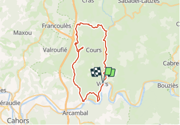
Tour Mountainbike von 29 km verfügbar auf Okzitanien, Lot, Saint-Géry-Vers. Diese Tour wird von sebcar vorgeschlagen.
Beschreibung
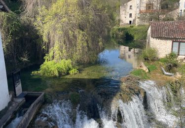
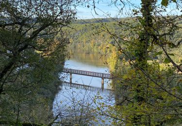
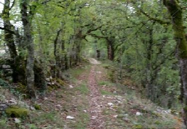
Au départ de la vallée du Lot, ce parcours sportif ne présente pas de grosse difficulté technique. Les traversées des routes départementales demandent une attention particulière, mais la vallée de la Rauze et les chemins entre les buis resteront dans les mémoires !
Ort
Land:
France
Region :
Okzitanien
Abteilung/Provinz :
Lot
Kommune :
Saint-Géry-Vers
Standort:
Unknown
Gehen Sie:(Dec)
Gehen Sie:(UTM)
385015 ; 4926894 (31T) N.
Kommentare
Touren in der Umgebung
![Tour Wandern Saint-Géry-Vers - Vers, St Gery Vallée du Lot - Photo](https://media.geolcdn.com/t/375/260/ext.jpg?maxdim=2&url=https%3A%2F%2Fservices.sitytrail.com%2FGeolivesWS%2FDownloadMedia.ashx%3FTrailID%3D103241%26Media%3D5146_6.jpg)
![Wandern Wandern](https://static1.geolcdn.com/sitytour/trail-icons/101.png)
Vers, St Gery Vallée du Lot
Wandern
Schwierig
(3)
Saint-Géry-Vers,
Okzitanien,
Lot,
France
![](/images/other/stat-length.png)
14,1 km | 19,8 km-effort
4h 0min
![](https://static1.geolcdn.com/siteimages/upload/files/16400158638029165_repeat_loop_refresh_sync_direction_icon.png)
Ja
![Tour Wandern Saint-Géry-Vers - Causse de Vers-7539719 - Photo](https://media.geolcdn.com/t/375/260/ext.jpg?maxdim=2&url=https%3A%2F%2Fmedia.geolcdn.com%2Ff%2Fb3f9a9fb-85e3-4f6c-afc6-c6de4fae8fc4.JPG)
![Wandern Wandern](https://static1.geolcdn.com/sitytour/trail-icons/101.png)
Causse de Vers-7539719
Wandern
Schwierig
(1)
Saint-Géry-Vers,
Okzitanien,
Lot,
France
![](/images/other/stat-length.png)
11,6 km | 15,9 km-effort
3h 36min
![](https://static1.geolcdn.com/siteimages/upload/files/16400158638029165_repeat_loop_refresh_sync_direction_icon.png)
Ja
![Tour Wandern Saint-Géry-Vers - Boucle Vers - Merlan gr46 - Photo](https://media.geolcdn.com/t/375/260/ext.jpg?maxdim=2&url=https%3A%2F%2Fmedia.geolcdn.com%2Ff%2F2b826dd5-3670-4ee5-a059-34afa2c2d67d.jpg)
![Wandern Wandern](https://static1.geolcdn.com/sitytour/trail-icons/101.png)
Boucle Vers - Merlan gr46
Wandern
Einfach
Saint-Géry-Vers,
Okzitanien,
Lot,
France
![](/images/other/stat-length.png)
14,7 km | 19,3 km-effort
4h 21min
![](https://static1.geolcdn.com/siteimages/upload/files/16400158638029165_repeat_loop_refresh_sync_direction_icon.png)
Ja
![Tour Wandern Arcambal - Galessie les Mazuts Barouillet - Photo](https://media.geolcdn.com/t/375/260/ext.jpg?maxdim=2&url=https%3A%2F%2Fmedia.geolcdn.com%2Ff%2F16327faa-cf00-4004-ade5-741b674ecd90.jpg)
![Wandern Wandern](https://static1.geolcdn.com/sitytour/trail-icons/101.png)
Galessie les Mazuts Barouillet
Wandern
Sehr leicht
Arcambal,
Okzitanien,
Lot,
France
![](/images/other/stat-length.png)
10,7 km | 13,9 km-effort
2h 30min
![](https://static1.geolcdn.com/siteimages/upload/files/16400158638029165_repeat_loop_refresh_sync_direction_icon.png)
Ja
![Tour Wandern Saint-Géry-Vers - Vers merlan pech picou - Photo](https://media.geolcdn.com/t/375/260/ext.jpg?maxdim=2&url=https%3A%2F%2Fmedia.geolcdn.com%2Ff%2F012b6a5e-2859-438e-93b8-84dfecc2d09a.jpg)
![Wandern Wandern](https://static1.geolcdn.com/sitytour/trail-icons/101.png)
Vers merlan pech picou
Wandern
Sehr leicht
Saint-Géry-Vers,
Okzitanien,
Lot,
France
![](/images/other/stat-length.png)
10,2 km | 13,5 km-effort
2h 13min
![](https://static1.geolcdn.com/siteimages/upload/files/16400158638029165_repeat_loop_refresh_sync_direction_icon.png)
Nein
![Tour Elektrofahrrad Saint-Géry-Vers - St gery St cirq Cabreret - Photo](https://media.geolcdn.com/t/375/260/ext.jpg?maxdim=2&url=https%3A%2F%2Fmedia.geolcdn.com%2Ff%2Fd519f58f-2190-4a19-bfda-7ad5dc0cd01a.jpg)
![Elektrofahrrad Elektrofahrrad](https://static1.geolcdn.com/sitytour/trail-icons/205.png)
St gery St cirq Cabreret
Elektrofahrrad
Sehr leicht
Saint-Géry-Vers,
Okzitanien,
Lot,
France
![](/images/other/stat-length.png)
39 km | 51 km-effort
3h 24min
![](https://static1.geolcdn.com/siteimages/upload/files/16400158638029165_repeat_loop_refresh_sync_direction_icon.png)
Ja
![Tour Wandern Saint-Géry-Vers - Moulin de Nouaillac - Photo](https://media.geolcdn.com/t/375/260/ext.jpg?maxdim=2&url=https%3A%2F%2Fstatic1.geolcdn.com%2Fsiteimages%2Fupload%2Ffiles%2F1553511878bg_sport_marche.png)
![Wandern Wandern](https://static1.geolcdn.com/sitytour/trail-icons/101.png)
Moulin de Nouaillac
Wandern
Medium
(1)
Saint-Géry-Vers,
Okzitanien,
Lot,
France
![](/images/other/stat-length.png)
13,3 km | 18,5 km-effort
4h 0min
![](https://static1.geolcdn.com/siteimages/upload/files/16400158638029165_repeat_loop_refresh_sync_direction_icon.png)
Ja
![Tour Wandern Saint-Géry-Vers - QUERCY (Nouaillac) - Photo](https://media.geolcdn.com/t/375/260/ext.jpg?maxdim=2&url=https%3A%2F%2Fservices.sitytrail.com%2FGeolivesWS%2FDownloadMedia.ashx%3FTrailID%3D474120%26Media%3Dfix__20150917172423.jpg)
![Wandern Wandern](https://static1.geolcdn.com/sitytour/trail-icons/101.png)
QUERCY (Nouaillac)
Wandern
Einfach
Saint-Géry-Vers,
Okzitanien,
Lot,
France
![](/images/other/stat-length.png)
11,7 km | 15,4 km-effort
3h 19min
![](https://static1.geolcdn.com/siteimages/upload/files/16400158638029165_repeat_loop_refresh_sync_direction_icon.png)
Ja
![Tour Wandern Saint-Géry-Vers - QUERCY (St-Géry) - Photo](https://media.geolcdn.com/t/375/260/ext.jpg?maxdim=2&url=https%3A%2F%2Fservices.sitytrail.com%2FGeolivesWS%2FDownloadMedia.ashx%3FTrailID%3D472037%26Media%3Dfix__20150915144627.jpg)
![Wandern Wandern](https://static1.geolcdn.com/sitytour/trail-icons/101.png)
QUERCY (St-Géry)
Wandern
Sehr leicht
Saint-Géry-Vers,
Okzitanien,
Lot,
France
![](/images/other/stat-length.png)
6,1 km | 7,3 km-effort
1h 40min
![](https://static1.geolcdn.com/siteimages/upload/files/16400158638029165_repeat_loop_refresh_sync_direction_icon.png)
Ja