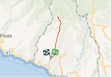
![](/images/other/stat-length.png)
![Tour Wandern Schœlcher - Cascade Anba so - Photo](https://media.geolcdn.com/t/1900/400/43e4ac65-2a53-4901-9be9-50bafa85662e.jpg&format=pjpeg&maxdim=2)
Cascade Anba so
Lamartiniere
Benutzer GUIDE
![Länge](/images/other/stat-length.png)
![Maximale Höhe](https://static1.geolcdn.com/siteimages/upload/files/1508320355ic_sort_altitude_max_24dp.png)
![Positive Höhendifferenz](https://static1.geolcdn.com/siteimages/upload/files/1508320355ic_sort_den_pos_24dp.png)
![Km-Effort](/images/other/stat-length.png)
![Min. Höhe](https://static1.geolcdn.com/siteimages/upload/files/1508320355ic_sort_altitude_min_24dp.png)
![Negative Höhendifferenz](https://static1.geolcdn.com/siteimages/upload/files/1508320355ic_sort_den_neg_24dp.png)
![Boucle](https://static1.geolcdn.com/siteimages/upload/files/16400158638029165_repeat_loop_refresh_sync_direction_icon.png)
![Wandern](https://static1.geolcdn.com/sitytour/trail-icons/101.png)
3h22
Schwierigkeit : Einfach
![Scannen Sie diesen QR-Code, um die Tour in der SityTrail-Anwendung zu öffnen](https://capi.geolives.com/qq0zvz2zws4bq2lad0pu/sitytour/trails/2982597/qr.png?size=200)
Kostenlosegpshiking-Anwendung
Über SityTrail
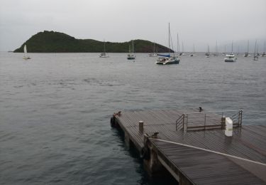
Tour Wandern von 6,5 km verfügbar auf Martinique, Unbekannt, Schœlcher. Diese Tour wird von Lamartiniere vorgeschlagen.
Beschreibung
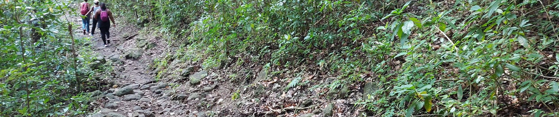
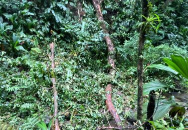
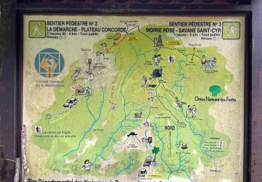
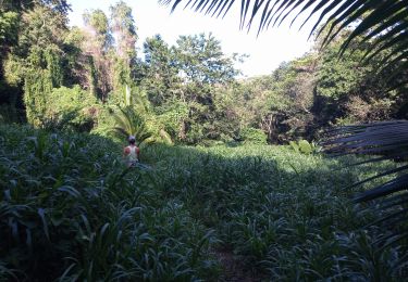
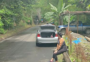
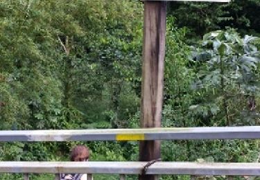
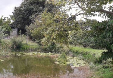
La cascade d’Anba So « en bas de la chute d’eau » se situe à Fond Lahaye sur la commune de Schoelcher. Le secteur est indiqué par un panneau depuis la nationale. Pour avoir vos 6 kms aller-retour, se garer à proximité de l’ école ou sur un petit emplacement un peu plus haut. Prendre ensuite ma direction de Fonds Duclos et suivre jusqu’ à la cascade. Possibilité d’apercevoir des mygales. Vous n’êtes pas connaisseurs, alors ne vous aventurez pas dans les sous-bois, restez sur le sentier. Belle balade familiale à travers une forêt luxuriante de mahogany et autres. En partie, route bétonnée, gués à traverser, sentier rocailleux, présence de racines. A éviter par temps de pluie.
Ort
Kommentare
Touren in der Umgebung
![Tour sport Fort-de-France - Absalon vers Didier - Photo](https://media.geolcdn.com/t/375/260/adf8a0b9-d2e0-4a1f-aaf4-a96938158482.jpg&format=jpg&maxdim=2)
sport
![](/images/other/stat-length.png)
![](https://static1.geolcdn.com/siteimages/upload/files/16400158638029165_repeat_loop_refresh_sync_direction_icon.png)
![Tour Wandern Fort-de-France - Boucle sur Fort-de-France - Photo](https://media.geolcdn.com/t/375/260/52470cd9-765b-4c99-b42e-cbdb3093f22a.jpg&format=jpg&maxdim=2)
![Wandern Wandern](https://static1.geolcdn.com/sitytour/trail-icons/101.png)
Wandern
![](/images/other/stat-length.png)
![](https://static1.geolcdn.com/siteimages/upload/files/16400158638029165_repeat_loop_refresh_sync_direction_icon.png)
![Tour sport Schœlcher - La Démarche-Morne Rose - Photo](https://media.geolcdn.com/t/375/260/8da19298-0e95-4207-a668-881dde22c6c8.jpg&format=jpg&maxdim=2)
sport
![](/images/other/stat-length.png)
![](https://static1.geolcdn.com/siteimages/upload/files/16400158638029165_repeat_loop_refresh_sync_direction_icon.png)
![Tour Wandern Schœlcher - Rivière Case Navire - Photo](https://media.geolcdn.com/t/375/260/416e8408-5f27-4589-b917-0dd1c59dc447.jpg&format=jpg&maxdim=2)
![Wandern Wandern](https://static1.geolcdn.com/sitytour/trail-icons/101.png)
Wandern
![](/images/other/stat-length.png)
![](https://static1.geolcdn.com/siteimages/upload/files/16400158638029165_repeat_loop_refresh_sync_direction_icon.png)
![Tour Wandern Schœlcher - Marche Didier, 6 km rapide - Photo](https://media.geolcdn.com/t/375/260/6c5417b5-d5a7-4c73-894d-206d2393aca0.jpg&format=jpg&maxdim=2)
![Wandern Wandern](https://static1.geolcdn.com/sitytour/trail-icons/101.png)
Wandern
![](/images/other/stat-length.png)
![](https://static1.geolcdn.com/siteimages/upload/files/16400158638029165_repeat_loop_refresh_sync_direction_icon.png)
![Tour Wandern Fort-de-France - MARTINIQUE - ABSALON PAR DIDIER 9.5KM - Photo](https://media.geolcdn.com/t/375/260/ext.jpg?maxdim=2&url=https%3A%2F%2Fservices.sitytrail.com%2FGeolivesWS%2FDownloadMedia.ashx%3FTrailID%3D411896%26Media%3D6d11f27d-0383-42e9-b49d-86a921cf2c6d.jpg)
![Wandern Wandern](https://static1.geolcdn.com/sitytour/trail-icons/101.png)
Wandern
![](/images/other/stat-length.png)
![](https://static1.geolcdn.com/siteimages/upload/files/16400158638029165_repeat_loop_refresh_sync_direction_icon.png)
![Tour Wandern Fort-de-France - Absalon par Didier - Photo](https://media.geolcdn.com/t/375/260/ext.jpg?maxdim=2&url=https%3A%2F%2Fservices.sitytrail.com%2FGeolivesWS%2FDownloadMedia.ashx%3FTrailID%3D271802%26Media%3Dfix__20140203190932.jpg)
![Wandern Wandern](https://static1.geolcdn.com/sitytour/trail-icons/101.png)
Wandern
![](/images/other/stat-length.png)
![](https://static1.geolcdn.com/siteimages/upload/files/16400158638029165_repeat_loop_refresh_sync_direction_icon.png)
![Tour Motorboot Fort-de-France - Bateau - Photo](https://media.geolcdn.com/t/375/260/5cd5d23a-a61b-489c-851a-303e7314a197.jpg&format=jpg&maxdim=2)
![Motorboot Motorboot](https://static1.geolcdn.com/sitytour/trail-icons/701.png)
Motorboot
![](/images/other/stat-length.png)
![](https://static1.geolcdn.com/siteimages/upload/files/16400158638029165_repeat_loop_refresh_sync_direction_icon.png)
![Tour Wandern Schœlcher - les 6 mares - Photo](https://media.geolcdn.com/t/375/260/6cbfb6eb-4d25-4e4d-b914-06046c0ab5ef.jpg&format=jpg&maxdim=2)
![Wandern Wandern](https://static1.geolcdn.com/sitytour/trail-icons/101.png)
Wandern
![](/images/other/stat-length.png)
![](https://static1.geolcdn.com/siteimages/upload/files/16400158638029165_repeat_loop_refresh_sync_direction_icon.png)