![](/images/other/stat-length.png)
![Tour Wandern Clion - La Chapelle Saint-Paul à Clion-sur-Seugne - Photo](https://media.geolcdn.com/t/1900/400/ext.pjpeg?maxdim=2&url=https%3A%2F%2Fstatic1.geolcdn.com%2Fsiteimages%2Fupload%2Ffiles%2F1553511878bg_sport_marche.png)
La Chapelle Saint-Paul à Clion-sur-Seugne
neoroll44
Benutzer
![Länge](/images/other/stat-length.png)
![Maximale Höhe](https://static1.geolcdn.com/siteimages/upload/files/1508320355ic_sort_altitude_max_24dp.png)
![Positive Höhendifferenz](https://static1.geolcdn.com/siteimages/upload/files/1508320355ic_sort_den_pos_24dp.png)
![Km-Effort](/images/other/stat-length.png)
![Min. Höhe](https://static1.geolcdn.com/siteimages/upload/files/1508320355ic_sort_altitude_min_24dp.png)
![Negative Höhendifferenz](https://static1.geolcdn.com/siteimages/upload/files/1508320355ic_sort_den_neg_24dp.png)
![Boucle](https://static1.geolcdn.com/siteimages/upload/files/16400158638029165_repeat_loop_refresh_sync_direction_icon.png)
![Wandern](https://static1.geolcdn.com/sitytour/trail-icons/101.png)
1h10
Schwierigkeit : Einfach
![Scannen Sie diesen QR-Code, um die Tour in der SityTrail-Anwendung zu öffnen](https://capi.geolives.com/qq0zvz2zws4bq2lad0pu/sitytour/trails/2981924/qr.png?size=200)
Kostenlosegpshiking-Anwendung
Über SityTrail
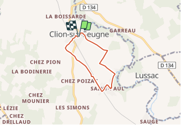
Tour Wandern von 4,8 km verfügbar auf Neu-Aquitanien, Charente-Maritime, Clion. Diese Tour wird von neoroll44 vorgeschlagen.
Beschreibung
Départ salle des fêtes de Clion-sur-Seugne.
(D/A) Dos au parking, se diriger à droite dans la Rue des Oiseaux. Au carrefour, suivre le balisage GR®360 Rouge et Blanc vers la droite, continuer sur la Route de la Varaze sur 700m environ.
(1) A l'embranchement tourner à droite, toujours en suivant le GR®360. Après 350m environ, emprunter le chemin de Fontaine vers la gauche et parvenir jusqu'à un pont sur la Seugne.
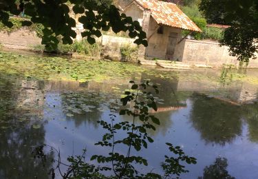
(2) Ne pas le traverser et longer le ruisseau jusqu'aux sources de Saint-Paul (les pèlerins de Compostelle y prenaient halte).
(3) Aller jusqu'à la chapelle, repartir à droite vers l'Ouest pour retrouver la Rue des Sources : vous quittez le GR® et suivez désormais le seul balisage Jaune. Dans le virage de la Rue des Fontaines, prendre en face et suivre la rue qui fait un virage à gauche. Laisser la rue de droite et poursuivre tout droit, couper la rue suivante vers la voie ferrée.
(4) Traverser avec prudence la voie ferrée et prendre un chemin qui part aussitôt à droite le long de celle-ci. Le chemin s'écarte un peu et rejoint un croisement.
(5) Au calvaire, continuer tout droit, puis au stade, prendre à droite sur la Rue du Stade. Traverser à nouveau la voie ferrée et poursuivre en face dans l'Avenue Saint-André. Tourner à droite Rue de Saint-Onge et à gauche pour retrouver le parking (D/A).
Ort
Kommentare
Touren in der Umgebung
![Tour Wandern Marignac - Marignac - Photo](https://media.geolcdn.com/t/375/260/ext.jpg?maxdim=2&url=https%3A%2F%2Fstatic1.geolcdn.com%2Fsiteimages%2Fupload%2Ffiles%2F1553511878bg_sport_marche.png)
![Wandern Wandern](https://static1.geolcdn.com/sitytour/trail-icons/101.png)
Wandern
![](/images/other/stat-length.png)
![](https://static1.geolcdn.com/siteimages/upload/files/16400158638029165_repeat_loop_refresh_sync_direction_icon.png)
![Tour Wandern Jonzac - Mail de Seugne-parcours pêche - Photo](https://media.geolcdn.com/t/375/260/0d074618-4b6e-4947-97bd-d51aab688f59.jpg&format=jpg&maxdim=2)
![Wandern Wandern](https://static1.geolcdn.com/sitytour/trail-icons/101.png)
Wandern
![](/images/other/stat-length.png)
![](https://static1.geolcdn.com/siteimages/upload/files/16400158638029165_repeat_loop_refresh_sync_direction_icon.png)
![Tour Wandern Clam - CLAM J Rando - Photo](https://media.geolcdn.com/t/375/260/bad43f0a-afba-4b67-842a-fde2b3083353.jpg&format=jpg&maxdim=2)
![Wandern Wandern](https://static1.geolcdn.com/sitytour/trail-icons/101.png)
Wandern
![](/images/other/stat-length.png)
![](https://static1.geolcdn.com/siteimages/upload/files/16400158638029165_repeat_loop_refresh_sync_direction_icon.png)
![Tour Wandern Saint-Georges-Antignac - St Georges Patricia - Photo](https://media.geolcdn.com/t/375/260/0103e147-e19c-403c-a45f-28ba3b0404ec.jpg&format=jpg&maxdim=2)
![Wandern Wandern](https://static1.geolcdn.com/sitytour/trail-icons/101.png)
Wandern
![](/images/other/stat-length.png)
![](https://static1.geolcdn.com/siteimages/upload/files/16400158638029165_repeat_loop_refresh_sync_direction_icon.png)
![Tour Quad Saint-Georges-Antignac - estuaire - Photo](https://media.geolcdn.com/t/375/260/00f68b19-921d-4e87-af18-ddbb9d8d1f56.jpg&format=jpg&maxdim=2)
![Quad Quad](https://static1.geolcdn.com/sitytour/trail-icons/404.png)
Quad
![](/images/other/stat-length.png)
![](https://static1.geolcdn.com/siteimages/upload/files/16400158638029165_repeat_loop_refresh_sync_direction_icon.png)
![Tour Wandern Clion - Du Pont des Ânes à la Chapelle de Saint-Paul autour de Clion - Photo](https://media.geolcdn.com/t/375/260/ext.jpg?maxdim=2&url=https%3A%2F%2Fstatic1.geolcdn.com%2Fsiteimages%2Fupload%2Ffiles%2F1553511878bg_sport_marche.png)
![Wandern Wandern](https://static1.geolcdn.com/sitytour/trail-icons/101.png)
Wandern
![](/images/other/stat-length.png)
![](https://static1.geolcdn.com/siteimages/upload/files/16400158638029165_repeat_loop_refresh_sync_direction_icon.png)
![Tour Wandern Saint-Germain-de-Lusignan - Les moulins du côté de Saint-Germain-de-Lusignan - Photo](https://media.geolcdn.com/t/375/260/ext.jpg?maxdim=2&url=https%3A%2F%2Fstatic1.geolcdn.com%2Fsiteimages%2Fupload%2Ffiles%2F1553511878bg_sport_marche.png)
![Wandern Wandern](https://static1.geolcdn.com/sitytour/trail-icons/101.png)
Wandern
![](/images/other/stat-length.png)
![](https://static1.geolcdn.com/siteimages/upload/files/16400158638029165_repeat_loop_refresh_sync_direction_icon.png)
![Tour Auto Guitinières - La Martinière - Photo](https://media.geolcdn.com/t/375/260/ext.jpg?maxdim=2&url=https%3A%2F%2Fstatic1.geolcdn.com%2Fsiteimages%2Fupload%2Ffiles%2F15247431544x4.jpg)
![Auto Auto](https://static1.geolcdn.com/sitytour/trail-icons/401.png)
Auto
![](/images/other/stat-length.png)
![](https://static1.geolcdn.com/siteimages/upload/files/16400158638029165_repeat_loop_refresh_sync_direction_icon.png)