![](/images/other/stat-length.png)
![Tour Wandern Gesves - MOZET _ (GESVES ) _ Marche Fédérale - Photo](https://media.geolcdn.com/t/1900/400/88a914d2-55c3-4101-b05d-dec9ea7c6ae9.jpg&format=pjpeg&maxdim=2)
MOZET _ (GESVES ) _ Marche Fédérale
jeangulu
Benutzer
![Länge](/images/other/stat-length.png)
Länge
22 km
![Maximale Höhe](https://static1.geolcdn.com/siteimages/upload/files/1508320355ic_sort_altitude_max_24dp.png)
Maximale Höhe
214 m
![Positive Höhendifferenz](https://static1.geolcdn.com/siteimages/upload/files/1508320355ic_sort_den_pos_24dp.png)
Positive Höhendifferenz
439 m
![Km-Effort](/images/other/stat-length.png)
Km-Effort
28 km
![Min. Höhe](https://static1.geolcdn.com/siteimages/upload/files/1508320355ic_sort_altitude_min_24dp.png)
Min. Höhe
84 m
![Negative Höhendifferenz](https://static1.geolcdn.com/siteimages/upload/files/1508320355ic_sort_den_neg_24dp.png)
Negative Höhendifferenz
439 m
![Boucle](https://static1.geolcdn.com/siteimages/upload/files/16400158638029165_repeat_loop_refresh_sync_direction_icon.png)
Boucle
Ja
Erstellungsdatum :
2021-10-17 07:17:42.424
Letzte Änderung :
2021-10-17 12:31:29.994
![Wandern](https://static1.geolcdn.com/sitytour/trail-icons/101.png)
5h12
Schwierigkeit : Schwierig
![Scannen Sie diesen QR-Code, um die Tour in der SityTrail-Anwendung zu öffnen](https://capi.geolives.com/qq0zvz2zws4bq2lad0pu/sitytour/trails/2973051/qr.png?size=200)
Kostenlosegpshiking-Anwendung
Über SityTrail
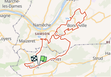
Tour Wandern von 22 km verfügbar auf Wallonien, Namur, Gesves. Diese Tour wird von jeangulu vorgeschlagen.
Beschreibung
Point de départ : Centre Récréatif de Mozet - Rue des Deux Chênes, 9 - 5340 MOZET.
Organisateur : NA 017 - LES SANGLIERS DU SAMSON.
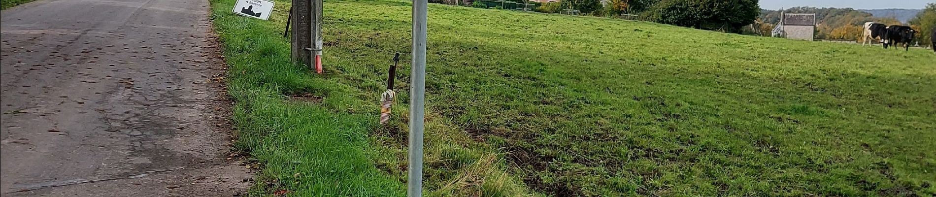
Très belle marche. Un point négatif, pas de contrôle et ni ravitaillement
Ort
Land:
Belgium
Region :
Wallonien
Abteilung/Provinz :
Namur
Kommune :
Gesves
Standort:
Unknown
Gehen Sie:(Dec)
Gehen Sie:(UTM)
641423 ; 5589700 (31U) N.
Kommentare
Touren in der Umgebung
![Tour Wandern Gesves - RB-Na-01 Raccourci - Vallée du Samson en Condroz namurois - Photo](https://media.geolcdn.com/t/375/260/ext.jpg?maxdim=2&url=https%3A%2F%2Fservices.sitytrail.com%2FGeolivesWS%2FDownloadMedia.ashx%3FTrailID%3D213609%26Media%3D506f23b2-0581-4f03-b006-9ca575596278.jpg)
![Wandern Wandern](https://static1.geolcdn.com/sitytour/trail-icons/101.png)
RB-Na-01 Raccourci - Vallée du Samson en Condroz namurois
Wandern
Sehr schwierig
(15)
Gesves,
Wallonien,
Namur,
Belgium
![](/images/other/stat-length.png)
18,3 km | 25 km-effort
5h 34min
![](https://static1.geolcdn.com/siteimages/upload/files/16400158638029165_repeat_loop_refresh_sync_direction_icon.png)
Ja
![Tour Wandern Gesves - RB-Na-01 Vallée du Samson en Condroz namurois - Photo](https://media.geolcdn.com/t/375/260/ext.jpg?maxdim=2&url=https%3A%2F%2Fservices.sitytrail.com%2FGeolivesWS%2FDownloadMedia.ashx%3FTrailID%3D179626%26Media%3D506f23b2-0581-4f03-b006-9ca575596278.jpg)
![Wandern Wandern](https://static1.geolcdn.com/sitytour/trail-icons/101.png)
RB-Na-01 Vallée du Samson en Condroz namurois
Wandern
Sehr schwierig
(15)
Gesves,
Wallonien,
Namur,
Belgium
![](/images/other/stat-length.png)
25 km | 33 km-effort
7h 26min
![](https://static1.geolcdn.com/siteimages/upload/files/16400158638029165_repeat_loop_refresh_sync_direction_icon.png)
Ja
![Tour Wandern Andenne - GESVES- Goyet- n°08- Eau - Photo](https://media.geolcdn.com/t/375/260/ext.jpg?maxdim=2&url=https%3A%2F%2Fservices.sitytrail.com%2FGeolivesWS%2FDownloadMedia.ashx%3FTrailID%3D121402%26Media%3D624555aa-5d04-4964-8666-f3856017c3be.jpg)
![Wandern Wandern](https://static1.geolcdn.com/sitytour/trail-icons/101.png)
GESVES- Goyet- n°08- Eau
Wandern
Schwierig
(9)
Andenne,
Wallonien,
Namur,
Belgium
![](/images/other/stat-length.png)
9,1 km | 12,3 km-effort
2h 36min
![](https://static1.geolcdn.com/siteimages/upload/files/16400158638029165_repeat_loop_refresh_sync_direction_icon.png)
Ja
![Tour Wandern Gesves - GESVES- Le Pré D'Amite- N°07- Bois - Photo](https://media.geolcdn.com/t/375/260/ext.jpg?maxdim=2&url=https%3A%2F%2Fservices.sitytrail.com%2FGeolivesWS%2FDownloadMedia.ashx%3FTrailID%3D121401%26Media%3D56c27e3a-fec1-4804-be43-ac45373f04b7.jpg)
![Wandern Wandern](https://static1.geolcdn.com/sitytour/trail-icons/101.png)
GESVES- Le Pré D'Amite- N°07- Bois
Wandern
Schwierig
(13)
Gesves,
Wallonien,
Namur,
Belgium
![](/images/other/stat-length.png)
9,4 km | 12,5 km-effort
2h 41min
![](https://static1.geolcdn.com/siteimages/upload/files/16400158638029165_repeat_loop_refresh_sync_direction_icon.png)
Ja
![Tour Wandern Gesves - GESVES -Mozet- N°06- Biodiversité - Photo](https://media.geolcdn.com/t/375/260/ext.jpg?maxdim=2&url=https%3A%2F%2Fservices.sitytrail.com%2FGeolivesWS%2FDownloadMedia.ashx%3FTrailID%3D121400%26Media%3D865b88e1-90ed-4454-a365-7e82ed8502df.JPG)
![Wandern Wandern](https://static1.geolcdn.com/sitytour/trail-icons/101.png)
GESVES -Mozet- N°06- Biodiversité
Wandern
Einfach
(10)
Gesves,
Wallonien,
Namur,
Belgium
![](/images/other/stat-length.png)
6,3 km | 7,8 km-effort
1h 41min
![](https://static1.geolcdn.com/siteimages/upload/files/16400158638029165_repeat_loop_refresh_sync_direction_icon.png)
Ja
![Tour Wandern Andenne - La Vadrouille des Castors - Photo](https://media.geolcdn.com/t/375/260/ext.jpg?maxdim=2&url=https%3A%2F%2Fservices.sitytrail.com%2FGeolivesWS%2FDownloadMedia.ashx%3FTrailID%3D272035%26Media%3D1f2a432f-27e3-4b07-a115-5648fc3f71b1.jpg)
![Wandern Wandern](https://static1.geolcdn.com/sitytour/trail-icons/101.png)
La Vadrouille des Castors
Wandern
Einfach
(5)
Andenne,
Wallonien,
Namur,
Belgium
![](/images/other/stat-length.png)
3,6 km | 4,8 km-effort
1h 0min
![](https://static1.geolcdn.com/siteimages/upload/files/16400158638029165_repeat_loop_refresh_sync_direction_icon.png)
Ja
![Tour Wandern Gesves - RF-Na-03-Goyet_Grande-boucle - Photo](https://media.geolcdn.com/t/375/260/ext.jpg?maxdim=2&url=https%3A%2F%2Fservices.sitytrail.com%2FGeolivesWS%2FDownloadMedia.ashx%3FTrailID%3D545745%26Media%3D72077e8d-e20a-4ee7-98f3-ad34263963e3.JPG)
![Wandern Wandern](https://static1.geolcdn.com/sitytour/trail-icons/101.png)
RF-Na-03-Goyet_Grande-boucle
Wandern
Medium
(5)
Gesves,
Wallonien,
Namur,
Belgium
![](/images/other/stat-length.png)
6,4 km | 8,9 km-effort
1h 54min
![](https://static1.geolcdn.com/siteimages/upload/files/16400158638029165_repeat_loop_refresh_sync_direction_icon.png)
Ja
![Tour Wandern Assesse - GG-Na-18_Sart-Bernard - Andenne - Photo](https://media.geolcdn.com/t/375/260/ee170bcd-2fb4-4927-aeb6-2a32aed3e834.jpg&format=jpg&maxdim=2)
![Wandern Wandern](https://static1.geolcdn.com/sitytour/trail-icons/101.png)
GG-Na-18_Sart-Bernard - Andenne
Wandern
Sehr schwierig
(2)
Assesse,
Wallonien,
Namur,
Belgium
![](/images/other/stat-length.png)
25 km | 32 km-effort
6h 49min
![](https://static1.geolcdn.com/siteimages/upload/files/16400158638029165_repeat_loop_refresh_sync_direction_icon.png)
Nein
![Tour Wandern Andenne - Promenade Thon-Samson - Photo](https://media.geolcdn.com/t/375/260/ext.jpg?maxdim=2&url=https%3A%2F%2Fservices.sitytrail.com%2FGeolivesWS%2FDownloadMedia.ashx%3FTrailID%3D272050%26Media%3Db6cbff1f-3300-45a6-b7c3-0805dc308e5c.jpg)
![Wandern Wandern](https://static1.geolcdn.com/sitytour/trail-icons/101.png)
Promenade Thon-Samson
Wandern
Einfach
(2)
Andenne,
Wallonien,
Namur,
Belgium
![](/images/other/stat-length.png)
6,5 km | 8,2 km-effort
1h 30min
![](https://static1.geolcdn.com/siteimages/upload/files/16400158638029165_repeat_loop_refresh_sync_direction_icon.png)
Ja