![](/images/other/stat-length.png)
![Tour Wandern Lalley - Rognon - Bouturet - Col des Selles - Photo](https://media.geolcdn.com/t/1900/400/99dacc12-cd68-4751-950e-95d08c71f9b7.jpg&format=pjpeg&maxdim=2)
Rognon - Bouturet - Col des Selles
patjobou
Benutzer
![Länge](/images/other/stat-length.png)
![Maximale Höhe](https://static1.geolcdn.com/siteimages/upload/files/1508320355ic_sort_altitude_max_24dp.png)
![Positive Höhendifferenz](https://static1.geolcdn.com/siteimages/upload/files/1508320355ic_sort_den_pos_24dp.png)
![Km-Effort](/images/other/stat-length.png)
![Min. Höhe](https://static1.geolcdn.com/siteimages/upload/files/1508320355ic_sort_altitude_min_24dp.png)
![Negative Höhendifferenz](https://static1.geolcdn.com/siteimages/upload/files/1508320355ic_sort_den_neg_24dp.png)
![Boucle](https://static1.geolcdn.com/siteimages/upload/files/16400158638029165_repeat_loop_refresh_sync_direction_icon.png)
![Wandern](https://static1.geolcdn.com/sitytour/trail-icons/101.png)
6h18
Schwierigkeit : Medium
![Scannen Sie diesen QR-Code, um die Tour in der SityTrail-Anwendung zu öffnen](https://capi.geolives.com/qq0zvz2zws4bq2lad0pu/sitytour/trails/2970369/qr.png?size=200)
Kostenlosegpshiking-Anwendung
Über SityTrail
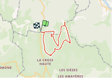
Tour Wandern von 15 km verfügbar auf Auvergne-Rhone-Alpen, Isère, Lalley. Diese Tour wird von patjobou vorgeschlagen.
Beschreibung
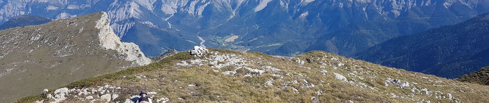
Une très belle boucle de crêtes par un temps idéal. Vue à 360° au sommet du Rognon. Le retour par le col des Selles permet d'éviter de reprendre la piste de montée.
La traversée en dahu vers le nord, après le Bouturet est un peu longue. Il est préférable de suivre l'itinéraire proposé sur l'IGN, qui longe la cloture jusqu’à 1430m environ, puis de rejoindre les nombreuses traces qui remontent vers le Nord, et le Col des Selles. Au Col des Selles on trouvera facilement le passage vers le nord et le vallon de l'Encura. Nous emprunterons ensuite des sentiers oubliés, mais encore visibles et praticables.
Ort
Kommentare
Touren in der Umgebung
![Tour Wandern Glandage - Le Jocou 2 - Photo](https://media.geolcdn.com/t/375/260/3db953da-6976-42b8-b004-e2f45e4d2956.jpg&format=jpg&maxdim=2)
![Wandern Wandern](https://static1.geolcdn.com/sitytour/trail-icons/101.png)
Wandern
![](/images/other/stat-length.png)
![](https://static1.geolcdn.com/siteimages/upload/files/16400158638029165_repeat_loop_refresh_sync_direction_icon.png)
![Tour Wandern Lus-la-Croix-Haute - Pointe Feuillette - Photo](https://media.geolcdn.com/t/375/260/c32e652d-9142-443d-9f13-87284c6d10a4.jpg&format=jpg&maxdim=2)
![Wandern Wandern](https://static1.geolcdn.com/sitytour/trail-icons/101.png)
Wandern
![](/images/other/stat-length.png)
![](https://static1.geolcdn.com/siteimages/upload/files/16400158638029165_repeat_loop_refresh_sync_direction_icon.png)
![Tour Wandern Glandage - 2022-09-05_12h23m25_Le Jocou-col de Seysse 12km.gpx (2).xml - Photo](https://media.geolcdn.com/t/375/260/7fa8e50f-0ae3-4fbb-b69e-805ffe4b1242.jpg&format=jpg&maxdim=2)
![Wandern Wandern](https://static1.geolcdn.com/sitytour/trail-icons/101.png)
Wandern
![](/images/other/stat-length.png)
![](https://static1.geolcdn.com/siteimages/upload/files/16400158638029165_repeat_loop_refresh_sync_direction_icon.png)
![Tour Wandern Glandage - 2022-06-24_19h10m37_Le Jocou par crêtes des Amousières 10km.gpx.xml - Photo](https://media.geolcdn.com/t/375/260/eeeff28a-8806-426d-aef8-2ba384b53865.jpg&format=jpg&maxdim=2)
![Wandern Wandern](https://static1.geolcdn.com/sitytour/trail-icons/101.png)
Wandern
![](/images/other/stat-length.png)
![](https://static1.geolcdn.com/siteimages/upload/files/16400158638029165_repeat_loop_refresh_sync_direction_icon.png)
![Tour Wandern Glandage - Grimone-Le Jocou 12km - Photo](https://media.geolcdn.com/t/375/260/cd25f2bd-a51d-4184-be3b-7961b829b3e2.jpg&format=jpg&maxdim=2)
![Wandern Wandern](https://static1.geolcdn.com/sitytour/trail-icons/101.png)
Wandern
![](/images/other/stat-length.png)
![](https://static1.geolcdn.com/siteimages/upload/files/16400158638029165_repeat_loop_refresh_sync_direction_icon.png)
![Tour Wandern Lus-la-Croix-Haute - R48 - Gorges des Amayères - Photo](https://media.geolcdn.com/t/375/260/4bbc825f-a565-4275-9665-85da99118f1b.jpg&format=jpg&maxdim=2)
![Wandern Wandern](https://static1.geolcdn.com/sitytour/trail-icons/101.png)
Wandern
![](/images/other/stat-length.png)
![](https://static1.geolcdn.com/siteimages/upload/files/16400158638029165_repeat_loop_refresh_sync_direction_icon.png)
![Tour Wandern Lus-la-Croix-Haute - Le Rognon - Photo](https://media.geolcdn.com/t/375/260/ext.jpg?maxdim=2&url=https%3A%2F%2Fstatic1.geolcdn.com%2Fsiteimages%2Fupload%2Ffiles%2F1553511878bg_sport_marche.png)
![Wandern Wandern](https://static1.geolcdn.com/sitytour/trail-icons/101.png)
Wandern
![](/images/other/stat-length.png)
![](https://static1.geolcdn.com/siteimages/upload/files/16400158638029165_repeat_loop_refresh_sync_direction_icon.png)
![Wandern Wandern](https://static1.geolcdn.com/sitytour/trail-icons/101.png)
Wandern
![](/images/other/stat-length.png)
![](https://static1.geolcdn.com/siteimages/upload/files/16400158638029165_repeat_loop_refresh_sync_direction_icon.png)
![Zu Fuß Zu Fuß](https://static1.geolcdn.com/sitytour/trail-icons/100.png)
Zu Fuß
![](/images/other/stat-length.png)
![](https://static1.geolcdn.com/siteimages/upload/files/16400158638029165_repeat_loop_refresh_sync_direction_icon.png)