![](/images/other/stat-length.png)
![Tour Wandern Montigny-sur-Loing - SityTrail - 101021 - Photo](https://media.geolcdn.com/t/1900/400/ext.pjpeg?maxdim=2&url=https%3A%2F%2Fstatic1.geolcdn.com%2Fsiteimages%2Fupload%2Ffiles%2F1553511878bg_sport_marche.png)
SityTrail - 101021
fmg
Benutzer
![Länge](/images/other/stat-length.png)
Länge
22 km
![Maximale Höhe](https://static1.geolcdn.com/siteimages/upload/files/1508320355ic_sort_altitude_max_24dp.png)
Maximale Höhe
133 m
![Positive Höhendifferenz](https://static1.geolcdn.com/siteimages/upload/files/1508320355ic_sort_den_pos_24dp.png)
Positive Höhendifferenz
271 m
![Km-Effort](/images/other/stat-length.png)
Km-Effort
25 km
![Min. Höhe](https://static1.geolcdn.com/siteimages/upload/files/1508320355ic_sort_altitude_min_24dp.png)
Min. Höhe
54 m
![Negative Höhendifferenz](https://static1.geolcdn.com/siteimages/upload/files/1508320355ic_sort_den_neg_24dp.png)
Negative Höhendifferenz
269 m
![Boucle](https://static1.geolcdn.com/siteimages/upload/files/16400158638029165_repeat_loop_refresh_sync_direction_icon.png)
Boucle
Ja
Erstellungsdatum :
2021-10-10 17:41:03.303
Letzte Änderung :
2022-03-21 06:09:33.124
![Wandern](https://static1.geolcdn.com/sitytour/trail-icons/101.png)
5h44
Schwierigkeit : Medium
![Scannen Sie diesen QR-Code, um die Tour in der SityTrail-Anwendung zu öffnen](https://capi.geolives.com/qq0zvz2zws4bq2lad0pu/sitytour/trails/2965600/qr.png?size=200)
Kostenlosegpshiking-Anwendung
Über SityTrail
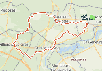
Tour Wandern von 22 km verfügbar auf Île-de-France, Seine-et-Marne, Montigny-sur-Loing. Diese Tour wird von fmg vorgeschlagen.
Beschreibung
- attention durant périodes de chasse !
- favoriser W.E.'s et périodes scolaires si besoin parking voitures (parking gare).
Ort
Land:
France
Region :
Île-de-France
Abteilung/Provinz :
Seine-et-Marne
Kommune :
Montigny-sur-Loing
Standort:
Unknown
Gehen Sie:(Dec)
Gehen Sie:(UTM)
480660 ; 5353747 (31U) N.
Kommentare
Touren in der Umgebung
![Tour Wandern Fontainebleau - GLM-150311 - PVerte-Fourceau-Béatrix - Photo](https://media.geolcdn.com/t/375/260/ext.jpg?maxdim=2&url=https%3A%2F%2Fservices.sitytrail.com%2FGeolivesWS%2FDownloadMedia.ashx%3FTrailID%3D394980%26Media%3D3b15c306-0eca-40de-a57d-3cf59ddfeba2.jpg)
![Wandern Wandern](https://static1.geolcdn.com/sitytour/trail-icons/101.png)
GLM-150311 - PVerte-Fourceau-Béatrix
Wandern
Medium
(1)
Fontainebleau,
Île-de-France,
Seine-et-Marne,
France
![](/images/other/stat-length.png)
16,5 km | 20 km-effort
6h 0min
![](https://static1.geolcdn.com/siteimages/upload/files/16400158638029165_repeat_loop_refresh_sync_direction_icon.png)
Ja
![Tour Wandern Bourron-Marlotte - Boucle Bourron Marlotte ( reco Didier) - Photo](https://media.geolcdn.com/t/375/260/ext.jpg?maxdim=2&url=https%3A%2F%2Fstatic1.geolcdn.com%2Fsiteimages%2Fupload%2Ffiles%2F1553511878bg_sport_marche.png)
![Wandern Wandern](https://static1.geolcdn.com/sitytour/trail-icons/101.png)
Boucle Bourron Marlotte ( reco Didier)
Wandern
Einfach
(1)
Bourron-Marlotte,
Île-de-France,
Seine-et-Marne,
France
![](/images/other/stat-length.png)
28 km | 32 km-effort
5h 35min
![](https://static1.geolcdn.com/siteimages/upload/files/16400158638029165_repeat_loop_refresh_sync_direction_icon.png)
Ja
![Tour Wandern Fontainebleau - Rocher Fourceau-Petit Mont Chauvet SR210523Ve?? fmg - Photo](https://media.geolcdn.com/t/375/260/cabc9437-0e04-4fa0-9f5b-0c9f73ac9000.jpg&format=jpg&maxdim=2)
![Wandern Wandern](https://static1.geolcdn.com/sitytour/trail-icons/101.png)
Rocher Fourceau-Petit Mont Chauvet SR210523Ve?? fmg
Wandern
Sehr schwierig
(2)
Fontainebleau,
Île-de-France,
Seine-et-Marne,
France
![](/images/other/stat-length.png)
19,5 km | 24 km-effort
5h 27min
![](https://static1.geolcdn.com/siteimages/upload/files/16400158638029165_repeat_loop_refresh_sync_direction_icon.png)
Ja
![Tour Wandern Fontainebleau - viennes carosses - Photo](https://media.geolcdn.com/t/375/260/9b54e644-4214-4411-b7b4-ea5a49e11005.jpg&format=jpg&maxdim=2)
![Wandern Wandern](https://static1.geolcdn.com/sitytour/trail-icons/101.png)
viennes carosses
Wandern
Sehr leicht
(2)
Fontainebleau,
Île-de-France,
Seine-et-Marne,
France
![](/images/other/stat-length.png)
10,8 km | 14 km-effort
2h 50min
![](https://static1.geolcdn.com/siteimages/upload/files/16400158638029165_repeat_loop_refresh_sync_direction_icon.png)
Ja
![Tour Wandern Fontainebleau - Boucle 30 km Thomery - Photo](https://media.geolcdn.com/t/375/260/0874c90c-8e55-44c8-845b-1a3f1ab9994c.jpg&format=jpg&maxdim=2)
![Wandern Wandern](https://static1.geolcdn.com/sitytour/trail-icons/101.png)
Boucle 30 km Thomery
Wandern
Schwierig
Fontainebleau,
Île-de-France,
Seine-et-Marne,
France
![](/images/other/stat-length.png)
31 km | 36 km-effort
6h 8min
![](https://static1.geolcdn.com/siteimages/upload/files/16400158638029165_repeat_loop_refresh_sync_direction_icon.png)
Ja
![Tour Wandern Fontainebleau - Sentier Denecourt N°9 Rocher des Demoiselles - Photo](https://media.geolcdn.com/t/375/260/ext.jpg?maxdim=2&url=https%3A%2F%2Fstatic1.geolcdn.com%2Fsiteimages%2Fupload%2Ffiles%2F1553511878bg_sport_marche.png)
![Wandern Wandern](https://static1.geolcdn.com/sitytour/trail-icons/101.png)
Sentier Denecourt N°9 Rocher des Demoiselles
Wandern
Medium
(1)
Fontainebleau,
Île-de-France,
Seine-et-Marne,
France
![](/images/other/stat-length.png)
5 km | 6,3 km-effort
1h 25min
![](https://static1.geolcdn.com/siteimages/upload/files/16400158638029165_repeat_loop_refresh_sync_direction_icon.png)
Ja
![Tour Zu Fuß Moret-Loing-et-Orvanne - La basse vallée du Lunain version 30 km - Photo](https://media.geolcdn.com/t/375/260/7e9d55c6-78ba-44d4-861c-7056fde52aaa.jpg&format=jpg&maxdim=2)
![Zu Fuß Zu Fuß](https://static1.geolcdn.com/sitytour/trail-icons/100.png)
La basse vallée du Lunain version 30 km
Zu Fuß
Schwierig
Moret-Loing-et-Orvanne,
Île-de-France,
Seine-et-Marne,
France
![](/images/other/stat-length.png)
30 km | 34 km-effort
7h 39min
![](https://static1.geolcdn.com/siteimages/upload/files/16400158638029165_repeat_loop_refresh_sync_direction_icon.png)
Ja
![Tour Zu Fuß Bourron-Marlotte - Boucle 30 km Bourron Marlotte - Montigny/ Loing / Grez - Photo](https://media.geolcdn.com/t/375/260/04503fe2-d147-4df8-acdc-18641722dd77.jpg&format=jpg&maxdim=2)
![Zu Fuß Zu Fuß](https://static1.geolcdn.com/sitytour/trail-icons/100.png)
Boucle 30 km Bourron Marlotte - Montigny/ Loing / Grez
Zu Fuß
Schwierig
Bourron-Marlotte,
Île-de-France,
Seine-et-Marne,
France
![](/images/other/stat-length.png)
28 km | 32 km-effort
7h 14min
![](https://static1.geolcdn.com/siteimages/upload/files/16400158638029165_repeat_loop_refresh_sync_direction_icon.png)
Ja
![Tour Wandern Fontainebleau - Boucle 20 km Fontainebleau vert galant - Photo](https://media.geolcdn.com/t/375/260/81db76b1-13eb-40e0-aee9-8545465c0b96.jpg&format=jpg&maxdim=2)
![Wandern Wandern](https://static1.geolcdn.com/sitytour/trail-icons/101.png)
Boucle 20 km Fontainebleau vert galant
Wandern
Einfach
(1)
Fontainebleau,
Île-de-France,
Seine-et-Marne,
France
![](/images/other/stat-length.png)
21 km | 24 km-effort
4h 35min
![](https://static1.geolcdn.com/siteimages/upload/files/16400158638029165_repeat_loop_refresh_sync_direction_icon.png)
Ja