![](/images/other/stat-length.png)
![Tour Wandern Grézac - Grézac mairie - Photo](https://media.geolcdn.com/t/1900/400/7be91d01-2e87-4799-88de-c1fb266ec17a.jpg&format=pjpeg&maxdim=2)
Grézac mairie
Gef50
Benutzer
![Länge](/images/other/stat-length.png)
Länge
7,3 km
![Maximale Höhe](https://static1.geolcdn.com/siteimages/upload/files/1508320355ic_sort_altitude_max_24dp.png)
Maximale Höhe
50 m
![Positive Höhendifferenz](https://static1.geolcdn.com/siteimages/upload/files/1508320355ic_sort_den_pos_24dp.png)
Positive Höhendifferenz
50 m
![Km-Effort](/images/other/stat-length.png)
Km-Effort
7,9 km
![Min. Höhe](https://static1.geolcdn.com/siteimages/upload/files/1508320355ic_sort_altitude_min_24dp.png)
Min. Höhe
14 m
![Negative Höhendifferenz](https://static1.geolcdn.com/siteimages/upload/files/1508320355ic_sort_den_neg_24dp.png)
Negative Höhendifferenz
51 m
![Boucle](https://static1.geolcdn.com/siteimages/upload/files/16400158638029165_repeat_loop_refresh_sync_direction_icon.png)
Boucle
Ja
Erstellungsdatum :
2021-10-10 12:00:09.844
Letzte Änderung :
2021-10-10 14:45:53.644
![Wandern](https://static1.geolcdn.com/sitytour/trail-icons/101.png)
1h48
Schwierigkeit : Medium
![Scannen Sie diesen QR-Code, um die Tour in der SityTrail-Anwendung zu öffnen](https://capi.geolives.com/qq0zvz2zws4bq2lad0pu/sitytour/trails/2964877/qr.png?size=200)
Kostenlosegpshiking-Anwendung
Über SityTrail
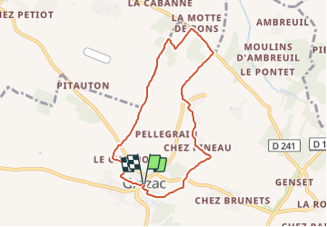
Tour Wandern von 7,3 km verfügbar auf Neu-Aquitanien, Charente-Maritime, Grézac. Diese Tour wird von Gef50 vorgeschlagen.
Beschreibung
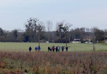
Randonnée facile au départ de la mairie de Grézac à travers les vignes et les bois.
A voir, moulin et belles maisons charentaises.
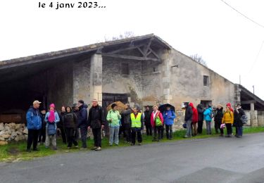
Prenez du bonheur.
Ort
Land:
France
Region :
Neu-Aquitanien
Abteilung/Provinz :
Charente-Maritime
Kommune :
Grézac
Standort:
Unknown
Gehen Sie:(Dec)
Gehen Sie:(UTM)
668426 ; 5052237 (30T) N.
Kommentare
Touren in der Umgebung
![Wandern Wandern](https://static1.geolcdn.com/sitytour/trail-icons/101.png)
17600 le Chay 7km 600
Wandern
Medium
(1)
Le Chay,
Neu-Aquitanien,
Charente-Maritime,
France
![](/images/other/stat-length.png)
7,6 km | 8,1 km-effort
1h 51min
![](https://static1.geolcdn.com/siteimages/upload/files/16400158638029165_repeat_loop_refresh_sync_direction_icon.png)
Ja
![Tour Hybrid-Bike Cozes - 20190530 Cozes Royan - Photo](https://media.geolcdn.com/t/375/260/39b78582-a465-4cd7-b907-55aad84e1646.jpg&format=jpg&maxdim=2)
![Hybrid-Bike Hybrid-Bike](https://static1.geolcdn.com/sitytour/trail-icons/203.png)
20190530 Cozes Royan
Hybrid-Bike
Einfach
Cozes,
Neu-Aquitanien,
Charente-Maritime,
France
![](/images/other/stat-length.png)
64 km | 72 km-effort
7h 33min
![](https://static1.geolcdn.com/siteimages/upload/files/16400158638029165_repeat_loop_refresh_sync_direction_icon.png)
Ja
![Tour Zu Fuß Corme-Écluse - Corme_écluse_Sentier_des_Arts - Photo](https://media.geolcdn.com/t/375/260/c30d85df-3632-4b9f-8716-cb49b161c426.jpg&format=jpg&maxdim=2)
![Zu Fuß Zu Fuß](https://static1.geolcdn.com/sitytour/trail-icons/100.png)
Corme_écluse_Sentier_des_Arts
Zu Fuß
Sehr leicht
Corme-Écluse,
Neu-Aquitanien,
Charente-Maritime,
France
![](/images/other/stat-length.png)
7 km | 7,5 km-effort
Unbekannt
![](https://static1.geolcdn.com/siteimages/upload/files/16400158638029165_repeat_loop_refresh_sync_direction_icon.png)
Ja
![Wandern Wandern](https://static1.geolcdn.com/sitytour/trail-icons/101.png)
17 Briagne-Corme Ecluse 7km300
Wandern
Medium
Corme-Écluse,
Neu-Aquitanien,
Charente-Maritime,
France
![](/images/other/stat-length.png)
7,3 km | 7,8 km-effort
1h 46min
![](https://static1.geolcdn.com/siteimages/upload/files/16400158638029165_repeat_loop_refresh_sync_direction_icon.png)
Ja
![Tour Wandern Cozes - Autour de Cozes - Photo](https://media.geolcdn.com/t/375/260/ext.jpg?maxdim=2&url=https%3A%2F%2Fstatic1.geolcdn.com%2Fsiteimages%2Fupload%2Ffiles%2F1553511878bg_sport_marche.png)
![Wandern Wandern](https://static1.geolcdn.com/sitytour/trail-icons/101.png)
Autour de Cozes
Wandern
Einfach
Cozes,
Neu-Aquitanien,
Charente-Maritime,
France
![](/images/other/stat-length.png)
10,7 km | 11,7 km-effort
2h 42min
![](https://static1.geolcdn.com/siteimages/upload/files/16400158638029165_repeat_loop_refresh_sync_direction_icon.png)
Ja
![Tour Wandern Semussac - 20250128 rando - Photo](https://media.geolcdn.com/t/375/260/ext.jpg?maxdim=2&url=https%3A%2F%2Fstatic1.geolcdn.com%2Fsiteimages%2Fupload%2Ffiles%2F1553511878bg_sport_marche.png)
![Wandern Wandern](https://static1.geolcdn.com/sitytour/trail-icons/101.png)
20250128 rando
Wandern
Sehr leicht
Semussac,
Neu-Aquitanien,
Charente-Maritime,
France
![](/images/other/stat-length.png)
5 km | 5,5 km-effort
1h 8min
![](https://static1.geolcdn.com/siteimages/upload/files/16400158638029165_repeat_loop_refresh_sync_direction_icon.png)
Ja
![Tour Radtourismus Corme-Écluse - Corme-Écluse 30kms - Photo](https://media.geolcdn.com/t/375/260/ext.jpg?maxdim=2&url=https%3A%2F%2Fstatic1.geolcdn.com%2Fsiteimages%2Fupload%2Ffiles%2F1524743154velo.jpg)
![Radtourismus Radtourismus](https://static1.geolcdn.com/sitytour/trail-icons/204.png)
Corme-Écluse 30kms
Radtourismus
Sehr leicht
Corme-Écluse,
Neu-Aquitanien,
Charente-Maritime,
France
![](/images/other/stat-length.png)
30 km | 32 km-effort
2h 16min
![](https://static1.geolcdn.com/siteimages/upload/files/16400158638029165_repeat_loop_refresh_sync_direction_icon.png)
Ja
![Tour Wandern Grézac - 17 Grezac 8km100 - Photo](https://media.geolcdn.com/t/375/260/ext.jpg?maxdim=2&url=https%3A%2F%2Fstatic1.geolcdn.com%2Fsiteimages%2Fupload%2Ffiles%2F1553511878bg_sport_marche.png)
![Wandern Wandern](https://static1.geolcdn.com/sitytour/trail-icons/101.png)
17 Grezac 8km100
Wandern
Einfach
Grézac,
Neu-Aquitanien,
Charente-Maritime,
France
![](/images/other/stat-length.png)
8,1 km | 8,8 km-effort
1h 59min
![](https://static1.geolcdn.com/siteimages/upload/files/16400158638029165_repeat_loop_refresh_sync_direction_icon.png)
Ja
![Tour Wandern Cozes - Comes - Photo](https://media.geolcdn.com/t/375/260/ext.jpg?maxdim=2&url=https%3A%2F%2Fstatic1.geolcdn.com%2Fsiteimages%2Fupload%2Ffiles%2F1553511878bg_sport_marche.png)
![Wandern Wandern](https://static1.geolcdn.com/sitytour/trail-icons/101.png)