![](/images/other/stat-length.png)
![Tour Wandern Cauterets - Du pont d'Espagne au lac de Gaube - Photo](https://media.geolcdn.com/t/1900/400/88684f5d-96be-4fc0-bef8-435c87e12c14.jpg&format=pjpeg&maxdim=2)
Du pont d'Espagne au lac de Gaube
micheldutilleul
Benutzer
![Länge](/images/other/stat-length.png)
![Maximale Höhe](https://static1.geolcdn.com/siteimages/upload/files/1508320355ic_sort_altitude_max_24dp.png)
![Positive Höhendifferenz](https://static1.geolcdn.com/siteimages/upload/files/1508320355ic_sort_den_pos_24dp.png)
![Km-Effort](/images/other/stat-length.png)
![Min. Höhe](https://static1.geolcdn.com/siteimages/upload/files/1508320355ic_sort_altitude_min_24dp.png)
![Negative Höhendifferenz](https://static1.geolcdn.com/siteimages/upload/files/1508320355ic_sort_den_neg_24dp.png)
![Boucle](https://static1.geolcdn.com/siteimages/upload/files/16400158638029165_repeat_loop_refresh_sync_direction_icon.png)
![Wandern](https://static1.geolcdn.com/sitytour/trail-icons/101.png)
3h13
Schwierigkeit : Medium
![Scannen Sie diesen QR-Code, um die Tour in der SityTrail-Anwendung zu öffnen](https://capi.geolives.com/qq0zvz2zws4bq2lad0pu/sitytour/trails/2961479/qr.png?size=200)
Kostenlosegpshiking-Anwendung
Über SityTrail
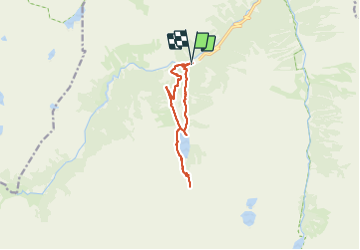
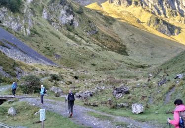
Tour Wandern von 11 km verfügbar auf Okzitanien, Hautes-Pyrénées, Cauterets. Diese Tour wird von micheldutilleul vorgeschlagen.
Beschreibung
Randonnée au départ du pont d'Espagne vers le lac de Gaube, puis direction le refuge des Oulettes de Gaube. Après la cabane du Pinet, faire encore quelques centaines de mètres pour avoir une vue panoramique sur le lac de Gaube. Puis retour vers le lac et le pont d'Espagne.
Ort
Kommentare
Touren in der Umgebung
![Tour Wandern Cauterets - Lac d'Estom - Photo](https://media.geolcdn.com/t/375/260/7676879f-23b9-4413-a840-ce71b34895f9.jpg&format=jpg&maxdim=2)
![Wandern Wandern](https://static1.geolcdn.com/sitytour/trail-icons/101.png)
Wandern
![](/images/other/stat-length.png)
![](https://static1.geolcdn.com/siteimages/upload/files/16400158638029165_repeat_loop_refresh_sync_direction_icon.png)
![Tour Wandern Cauterets - promenade Russell - Photo](https://media.geolcdn.com/t/375/260/ext.jpg?maxdim=2&url=https%3A%2F%2Fservices.sitytrail.com%2FGeolivesWS%2FDownloadMedia.ashx%3FTrailID%3D1020841%26Media%3Dfix__20180812100734.jpg)
![Wandern Wandern](https://static1.geolcdn.com/sitytour/trail-icons/101.png)
Wandern
![](/images/other/stat-length.png)
![](https://static1.geolcdn.com/siteimages/upload/files/16400158638029165_repeat_loop_refresh_sync_direction_icon.png)
![Tour Wandern Cauterets - Chemin des cascades - Photo](https://media.geolcdn.com/t/375/260/ext.jpg?maxdim=2&url=https%3A%2F%2Fservices.sitytrail.com%2FGeolivesWS%2FDownloadMedia.ashx%3FTrailID%3D807444%26Media%3Dfix__20170811162357.jpg)
![Wandern Wandern](https://static1.geolcdn.com/sitytour/trail-icons/101.png)
Wandern
![](/images/other/stat-length.png)
![](https://static1.geolcdn.com/siteimages/upload/files/16400158638029165_repeat_loop_refresh_sync_direction_icon.png)
![Tour Wandern Cauterets - 2023-01-01 Marche Refuge Wallon vers Pont Espagne - Photo](https://media.geolcdn.com/t/375/260/31c1be11-6f17-420f-a84b-6c60a0fd5fb7.jpg&format=jpg&maxdim=2)
![Wandern Wandern](https://static1.geolcdn.com/sitytour/trail-icons/101.png)
Wandern
![](/images/other/stat-length.png)
![](https://static1.geolcdn.com/siteimages/upload/files/16400158638029165_repeat_loop_refresh_sync_direction_icon.png)
![Tour Wandern Cauterets - 2022-12-31 Marche Refuge du Clot vers Refuge Wallon - Photo](https://media.geolcdn.com/t/375/260/b3b3e7b5-b7c0-4d24-bf3e-ca9e2bad9ac8.jpg&format=jpg&maxdim=2)
![Wandern Wandern](https://static1.geolcdn.com/sitytour/trail-icons/101.png)
Wandern
![](/images/other/stat-length.png)
![](https://static1.geolcdn.com/siteimages/upload/files/16400158638029165_repeat_loop_refresh_sync_direction_icon.png)
![Tour Wandern Cauterets - CAUTERETS Le chemin des pères G3 le 14/10/2022](https://media.geolcdn.com/t/375/260/15fc21f1-76b1-44b0-aa82-d95bc69ee2d3.jpg&format=jpg&maxdim=2)
![Wandern Wandern](https://static1.geolcdn.com/sitytour/trail-icons/101.png)
Wandern
![](/images/other/stat-length.png)
![](https://static1.geolcdn.com/siteimages/upload/files/16400158638029165_repeat_loop_refresh_sync_direction_icon.png)
![Tour Wandern Cauterets - Pic d'Estibe Aute - Photo](https://media.geolcdn.com/t/375/260/ext.jpg?maxdim=2&url=https%3A%2F%2Fstatic1.geolcdn.com%2Fsiteimages%2Fupload%2Ffiles%2F1553511878bg_sport_marche.png)
![Wandern Wandern](https://static1.geolcdn.com/sitytour/trail-icons/101.png)
Wandern
![](/images/other/stat-length.png)
![](https://static1.geolcdn.com/siteimages/upload/files/16400158638029165_repeat_loop_refresh_sync_direction_icon.png)
![Tour Wandern Cauterets - cauterets cascades G3 2024 - Photo](https://media.geolcdn.com/t/375/260/14e9c8b1-56b3-4748-8540-3737d87573df.jpg&format=jpg&maxdim=2)
![Wandern Wandern](https://static1.geolcdn.com/sitytour/trail-icons/101.png)
Wandern
![](/images/other/stat-length.png)
![](https://static1.geolcdn.com/siteimages/upload/files/16400158638029165_repeat_loop_refresh_sync_direction_icon.png)
![Tour Wandern Cauterets - 65-Lac_Bleu_ ILHEOU_12Km -680m - Photo](https://media.geolcdn.com/t/375/260/fc11451b-2c97-4efe-a40a-735eb39f0050.jpg&format=jpg&maxdim=2)
![Wandern Wandern](https://static1.geolcdn.com/sitytour/trail-icons/101.png)
Wandern
![](/images/other/stat-length.png)
![](https://static1.geolcdn.com/siteimages/upload/files/16400158638029165_repeat_loop_refresh_sync_direction_icon.png)