![](/images/other/stat-length.png)
![Tour Wandern Saint-Victor-de-Buthon - [Itinéraire] Le chemin des demoiselles - Photo](https://media.geolcdn.com/t/1900/400/0dafef58-5839-4846-8b48-f9c7f8aedcf0.jpeg&format=pjpeg&maxdim=2)
[Itinéraire] Le chemin des demoiselles
ODDAD78
Benutzer
![Länge](/images/other/stat-length.png)
![Maximale Höhe](https://static1.geolcdn.com/siteimages/upload/files/1508320355ic_sort_altitude_max_24dp.png)
![Positive Höhendifferenz](https://static1.geolcdn.com/siteimages/upload/files/1508320355ic_sort_den_pos_24dp.png)
![Km-Effort](/images/other/stat-length.png)
![Min. Höhe](https://static1.geolcdn.com/siteimages/upload/files/1508320355ic_sort_altitude_min_24dp.png)
![Negative Höhendifferenz](https://static1.geolcdn.com/siteimages/upload/files/1508320355ic_sort_den_neg_24dp.png)
![Boucle](https://static1.geolcdn.com/siteimages/upload/files/16400158638029165_repeat_loop_refresh_sync_direction_icon.png)
![Wandern](https://static1.geolcdn.com/sitytour/trail-icons/101.png)
2h14
Schwierigkeit : Medium
![Scannen Sie diesen QR-Code, um die Tour in der SityTrail-Anwendung zu öffnen](https://capi.geolives.com/qq0zvz2zws4bq2lad0pu/sitytour/trails/2950832/qr.png?size=200)
Kostenlosegpshiking-Anwendung
Über SityTrail
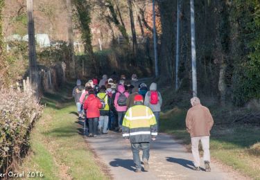
Tour Wandern von 8,4 km verfügbar auf Zentrum-Loiretal, Eure-et-Loir, Saint-Victor-de-Buthon. Diese Tour wird von ODDAD78 vorgeschlagen.
Beschreibung
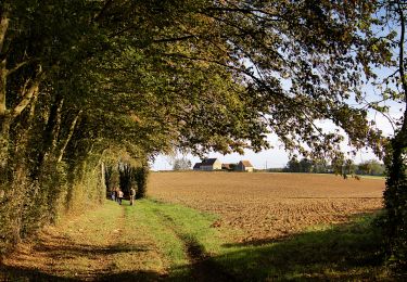
Profitez d'une promenade avec de nombreux points de vue sur le paysage bocager percheron : vergers, chemins creux bordés de haies et vaches normandes ou limousines.
Ce circuit est labellisé FFRandonnée.
Départ / Arrivée : St-Victor-de-Buthon
Dos au parking, suivre la D 5 qui monte à gauche. A la croix du cimetière, bifurquer à droite vers la Houlière. Entre la Houlière et le clos des Demoiselles, prendre le chemin à gauche (fond de fossé). Ne pas suivre la bordure du champ par la partie haute. Traverser le hameau du Clos-des-Demoiselles et poursuivre tout droit par le chemin. A la ferme de la Barre-aux-Popelins, suivre la D 349-7, à droite.
Dans le virage, continuer tout droit par le chemin sur 100m, puis suivre le chemin de gauche (ancienne ligne de chemin de fer de La Loupe à Brou).
Emprunter la D 5 à gauche. Passer devant l'ancienne maison de garde-barrière de la Madeleine, puis partir à droite en direction des Orieux (points de vue sur le bocage).
A la ferme de la Grisonnière (petit verger à droite), s'engager dans le chemin à gauche entre les allées d'arbres, puis continuer par la petite route et, à la station de pompage, traverser la D 143 vers la Pointe-aux-Canards.
A la fourche, suivre le chemin de gauche (vue sur le clocher ajouré de l'église). Après le château d'eau, descendre à gauche entre les deux silos, puis emprunter la D 5 à gauche pour rejoindre le bourg.
Textes Rando-Perche :
https://rando-perche.fr/a-pied/le-chemin-des-demoiselles/
Ort
Kommentare
Touren in der Umgebung
![Tour Wandern Saint-Victor-de-Buthon - Saint-Victor-de-Buthon - Thiron-Gardais 17 km - Photo](https://media.geolcdn.com/t/375/260/3ae028f3-b202-4737-a651-405412efcb03.jpg&format=jpg&maxdim=2)
![Wandern Wandern](https://static1.geolcdn.com/sitytour/trail-icons/101.png)
Wandern
![](/images/other/stat-length.png)
![](https://static1.geolcdn.com/siteimages/upload/files/16400158638029165_repeat_loop_refresh_sync_direction_icon.png)
![Tour Wandern Saint-Victor-de-Buthon - St Victor de Buthon 22 - Photo](https://media.geolcdn.com/t/375/260/ext.jpg?maxdim=2&url=https%3A%2F%2Fstatic1.geolcdn.com%2Fsiteimages%2Fupload%2Ffiles%2F1553511878bg_sport_marche.png)
![Wandern Wandern](https://static1.geolcdn.com/sitytour/trail-icons/101.png)
Wandern
![](/images/other/stat-length.png)
![](https://static1.geolcdn.com/siteimages/upload/files/16400158638029165_repeat_loop_refresh_sync_direction_icon.png)
![Tour Wandern Saint-Victor-de-Buthon - Saint-Victor de Buthon 8,5 km - Photo](https://media.geolcdn.com/t/375/260/61e755b7-5f1a-4c9e-bf1b-a0571b8b0702.jpeg&format=jpg&maxdim=2)
![Wandern Wandern](https://static1.geolcdn.com/sitytour/trail-icons/101.png)
Wandern
![](/images/other/stat-length.png)
![](https://static1.geolcdn.com/siteimages/upload/files/16400158638029165_repeat_loop_refresh_sync_direction_icon.png)
![Tour Mountainbike Saint-Victor-de-Buthon - [Itinéraire] Par monts et par vaux - Photo](https://media.geolcdn.com/t/375/260/ext.jpg?maxdim=2&url=https%3A%2F%2Fstatic1.geolcdn.com%2Fsiteimages%2Fupload%2Ffiles%2F1524743154velo.jpg)
![Mountainbike Mountainbike](https://static1.geolcdn.com/sitytour/trail-icons/202.png)
Mountainbike
![](/images/other/stat-length.png)
![](https://static1.geolcdn.com/siteimages/upload/files/16400158638029165_repeat_loop_refresh_sync_direction_icon.png)
![Tour Wandern Saint-Victor-de-Buthon - 10747652-ZLa Loupe - St Victor de Buthon 17.21 - Photo](https://media.geolcdn.com/t/375/260/ext.jpg?maxdim=2&url=https%3A%2F%2Fstatic1.geolcdn.com%2Fsiteimages%2Fupload%2Ffiles%2F1553511878bg_sport_marche.png)
![Wandern Wandern](https://static1.geolcdn.com/sitytour/trail-icons/101.png)
Wandern
![](/images/other/stat-length.png)
![](https://static1.geolcdn.com/siteimages/upload/files/16400158638029165_repeat_loop_refresh_sync_direction_icon.png)
![Tour Wandern Saint-Victor-de-Buthon - Harvard - Photo](https://media.geolcdn.com/t/375/260/ext.jpg?maxdim=2&url=https%3A%2F%2Fstatic1.geolcdn.com%2Fsiteimages%2Fupload%2Ffiles%2F1553511878bg_sport_marche.png)
![Wandern Wandern](https://static1.geolcdn.com/sitytour/trail-icons/101.png)
Wandern
![](/images/other/stat-length.png)
![](https://static1.geolcdn.com/siteimages/upload/files/16400158638029165_repeat_loop_refresh_sync_direction_icon.png)
![Tour Andere Aktivitäten Saint-Victor-de-Buthon - Quad avec ceriaque - Photo](https://media.geolcdn.com/t/375/260/ext.jpg?maxdim=2&url=https%3A%2F%2Fstatic1.geolcdn.com%2Fsiteimages%2Fupload%2Ffiles%2F1545311037marcheuse_200dpi.jpg)
![Andere Aktivitäten Andere Aktivitäten](https://static1.geolcdn.com/sitytour/trail-icons/900.png)
Andere Aktivitäten
![](/images/other/stat-length.png)
![](https://static1.geolcdn.com/siteimages/upload/files/16400158638029165_repeat_loop_refresh_sync_direction_icon.png)
![Tour Zu Fuß Saint-Victor-de-Buthon - Saint Victor de Buthon, Le point du Jour, 10km - Photo](https://media.geolcdn.com/t/375/260/ext.jpg?maxdim=2&url=https%3A%2F%2Fstatic1.geolcdn.com%2Fsiteimages%2Fupload%2Ffiles%2F1545311037marcheuse_200dpi.jpg)
![Zu Fuß Zu Fuß](https://static1.geolcdn.com/sitytour/trail-icons/100.png)
Zu Fuß
![](/images/other/stat-length.png)
![](https://static1.geolcdn.com/siteimages/upload/files/16400158638029165_repeat_loop_refresh_sync_direction_icon.png)
![Tour Zu Fuß Saint-Victor-de-Buthon - St Victor de Buthon l'Ermitage 9km - Photo](https://media.geolcdn.com/t/375/260/ext.jpg?maxdim=2&url=https%3A%2F%2Fstatic1.geolcdn.com%2Fsiteimages%2Fupload%2Ffiles%2F1545311037marcheuse_200dpi.jpg)
![Zu Fuß Zu Fuß](https://static1.geolcdn.com/sitytour/trail-icons/100.png)
Zu Fuß
![](/images/other/stat-length.png)
![](https://static1.geolcdn.com/siteimages/upload/files/16400158638029165_repeat_loop_refresh_sync_direction_icon.png)