![](/images/other/stat-length.png)
![Tour Wandern Châtillon-en-Diois - Combau cretes versant Est - Photo](https://media.geolcdn.com/t/1900/400/8ad08a83-32f0-45ef-8dff-a3963d66088a.jpg&format=pjpeg&maxdim=2)
Combau cretes versant Est
ajd26
Benutzer
![Länge](/images/other/stat-length.png)
Länge
12,4 km
![Maximale Höhe](https://static1.geolcdn.com/siteimages/upload/files/1508320355ic_sort_altitude_max_24dp.png)
Maximale Höhe
1743 m
![Positive Höhendifferenz](https://static1.geolcdn.com/siteimages/upload/files/1508320355ic_sort_den_pos_24dp.png)
Positive Höhendifferenz
599 m
![Km-Effort](/images/other/stat-length.png)
Km-Effort
20 km
![Min. Höhe](https://static1.geolcdn.com/siteimages/upload/files/1508320355ic_sort_altitude_min_24dp.png)
Min. Höhe
1365 m
![Negative Höhendifferenz](https://static1.geolcdn.com/siteimages/upload/files/1508320355ic_sort_den_neg_24dp.png)
Negative Höhendifferenz
598 m
![Boucle](https://static1.geolcdn.com/siteimages/upload/files/16400158638029165_repeat_loop_refresh_sync_direction_icon.png)
Boucle
Ja
Erstellungsdatum :
2021-09-23 07:51:28.0
Letzte Änderung :
2021-09-24 08:18:48.382
![Wandern](https://static1.geolcdn.com/sitytour/trail-icons/101.png)
3h55
Schwierigkeit : Einfach
![Scannen Sie diesen QR-Code, um die Tour in der SityTrail-Anwendung zu öffnen](https://capi.geolives.com/qq0zvz2zws4bq2lad0pu/sitytour/trails/2946955/qr.png?size=200)
Kostenlosegpshiking-Anwendung
Über SityTrail
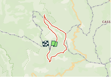
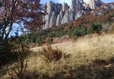
Tour Wandern von 12,4 km verfügbar auf Auvergne-Rhone-Alpen, Drôme, Châtillon-en-Diois. Diese Tour wird von ajd26 vorgeschlagen.
Beschreibung
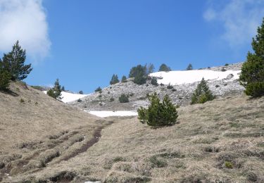
col de cote Chevre, col de la Lauzette, tete de Paorzel, les 4 tètes, pas de l'Essaure
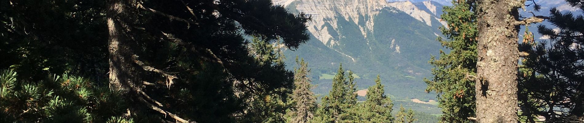
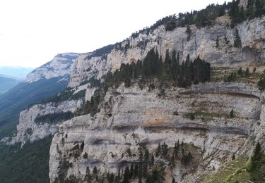
très beaux panoramas tout au long des crêtes sur le Triève, le Devoluy, l'Oisans, le mont Aiguille, et le Ventoux au sud
Ort
Land:
France
Region :
Auvergne-Rhone-Alpen
Abteilung/Provinz :
Drôme
Kommune :
Châtillon-en-Diois
Standort:
Treschenu-Creyers
Gehen Sie:(Dec)
Gehen Sie:(UTM)
702937 ; 4959987 (31T) N.
Kommentare
Touren in der Umgebung
![Wandern Wandern](https://static1.geolcdn.com/sitytour/trail-icons/101.png)
2022-02-25_09h07m39_SityTrail - 2832632 - vallon-combauxtete-chevaliere-13km....
Wandern
Schwierig
(1)
Châtillon-en-Diois,
Auvergne-Rhone-Alpen,
Drôme,
France
![](/images/other/stat-length.png)
13 km | 22 km-effort
6h 0min
![](https://static1.geolcdn.com/siteimages/upload/files/16400158638029165_repeat_loop_refresh_sync_direction_icon.png)
Ja
![Tour Wandern Châtillon-en-Diois - 2015-05-30 11:51 - Photo](https://media.geolcdn.com/t/375/260/f6b04bda-399a-4e8f-a718-7c3ac5f32c3c.jpg&format=jpg&maxdim=2)
![Wandern Wandern](https://static1.geolcdn.com/sitytour/trail-icons/101.png)
2015-05-30 11:51
Wandern
Sehr schwierig
(1)
Châtillon-en-Diois,
Auvergne-Rhone-Alpen,
Drôme,
France
![](/images/other/stat-length.png)
13 km | 28 km-effort
6h 20min
![](https://static1.geolcdn.com/siteimages/upload/files/16400158638029165_repeat_loop_refresh_sync_direction_icon.png)
Ja
![Wandern Wandern](https://static1.geolcdn.com/sitytour/trail-icons/101.png)
Combau-TêteChevalière 05-05-2018
Wandern
Einfach
(4)
Châtillon-en-Diois,
Auvergne-Rhone-Alpen,
Drôme,
France
![](/images/other/stat-length.png)
10,2 km | 17,1 km-effort
4h 0min
![](https://static1.geolcdn.com/siteimages/upload/files/16400158638029165_repeat_loop_refresh_sync_direction_icon.png)
Ja
![Tour Wandern Châtillon-en-Diois - F26 Combau Fontaine Pourrie - Photo](https://media.geolcdn.com/t/375/260/ext.jpg?maxdim=2&url=https%3A%2F%2Fservices.sitytrail.com%2FGeolivesWS%2FDownloadMedia.ashx%3FTrailID%3D311756%26Media%3Dfix__20140611142210.jpg)
![Wandern Wandern](https://static1.geolcdn.com/sitytour/trail-icons/101.png)
F26 Combau Fontaine Pourrie
Wandern
Medium
(1)
Châtillon-en-Diois,
Auvergne-Rhone-Alpen,
Drôme,
France
![](/images/other/stat-length.png)
17 km | 29 km-effort
6h 9min
![](https://static1.geolcdn.com/siteimages/upload/files/16400158638029165_repeat_loop_refresh_sync_direction_icon.png)
Ja
![Tour Wandern Chichilianne - Le Platary - Photo](https://media.geolcdn.com/t/375/260/ext.jpg?maxdim=2&url=https%3A%2F%2Fservices.sitytrail.com%2FGeolivesWS%2FDownloadMedia.ashx%3FTrailID%3D836793%26Media%3Dfix__20170928142121.jpg)
![Wandern Wandern](https://static1.geolcdn.com/sitytour/trail-icons/101.png)
Le Platary
Wandern
Medium
(2)
Chichilianne,
Auvergne-Rhone-Alpen,
Isère,
France
![](/images/other/stat-length.png)
6,6 km | 12,1 km-effort
2h 29min
![](https://static1.geolcdn.com/siteimages/upload/files/16400158638029165_repeat_loop_refresh_sync_direction_icon.png)
Ja
![Tour Wandern Châtillon-en-Diois - 26 vallon combeau - Photo](https://media.geolcdn.com/t/375/260/5dff522d-7866-41ae-b85a-1900434d82e5.jpg&format=jpg&maxdim=2)
![Wandern Wandern](https://static1.geolcdn.com/sitytour/trail-icons/101.png)
26 vallon combeau
Wandern
Medium
Châtillon-en-Diois,
Auvergne-Rhone-Alpen,
Drôme,
France
![](/images/other/stat-length.png)
13,3 km | 24 km-effort
6h 48min
![](https://static1.geolcdn.com/siteimages/upload/files/16400158638029165_repeat_loop_refresh_sync_direction_icon.png)
Ja
![Tour Wandern Châtillon-en-Diois - 26 grimone j1 - Photo](https://media.geolcdn.com/t/375/260/781a4ae6-6994-4c28-83c7-bfb5368271f2.jpg&format=jpg&maxdim=2)
![Wandern Wandern](https://static1.geolcdn.com/sitytour/trail-icons/101.png)
26 grimone j1
Wandern
Einfach
Châtillon-en-Diois,
Auvergne-Rhone-Alpen,
Drôme,
France
![](/images/other/stat-length.png)
14,9 km | 26 km-effort
6h 15min
![](https://static1.geolcdn.com/siteimages/upload/files/16400158638029165_repeat_loop_refresh_sync_direction_icon.png)
Nein
![Tour Wandern Châtillon-en-Diois - Les crêtes du cirque d'Archiane - Photo](https://media.geolcdn.com/t/375/260/09133ccd-d124-4373-a8e4-85c1f4032737.jpg&format=jpg&maxdim=2)
![Wandern Wandern](https://static1.geolcdn.com/sitytour/trail-icons/101.png)
Les crêtes du cirque d'Archiane
Wandern
Schwierig
Châtillon-en-Diois,
Auvergne-Rhone-Alpen,
Drôme,
France
![](/images/other/stat-length.png)
23 km | 41 km-effort
6h 35min
![](https://static1.geolcdn.com/siteimages/upload/files/16400158638029165_repeat_loop_refresh_sync_direction_icon.png)
Ja
![Tour Wandern Châtillon-en-Diois - 2017-06-04 15:45:22 - Photo](https://media.geolcdn.com/t/375/260/4049bbeb-10e6-465f-8c97-cefb4daee153.jpg&format=jpg&maxdim=2)
![Wandern Wandern](https://static1.geolcdn.com/sitytour/trail-icons/101.png)
2017-06-04 15:45:22
Wandern
Medium
(1)
Châtillon-en-Diois,
Auvergne-Rhone-Alpen,
Drôme,
France
![](/images/other/stat-length.png)
11,4 km | 19,9 km-effort
Unbekannt
![](https://static1.geolcdn.com/siteimages/upload/files/16400158638029165_repeat_loop_refresh_sync_direction_icon.png)
Ja