![](/images/other/stat-length.png)
![Tour Wandern Saint-Laurent-des-Arbres - St Laurent des Arbres Montagne St Genies - Photo](https://media.geolcdn.com/t/1900/400/87789e4e-a0b1-4843-8d74-95689b72d29e.jpg&format=pjpeg&maxdim=2)
St Laurent des Arbres Montagne St Genies
Manoune
Benutzer
![Länge](/images/other/stat-length.png)
![Maximale Höhe](https://static1.geolcdn.com/siteimages/upload/files/1508320355ic_sort_altitude_max_24dp.png)
![Positive Höhendifferenz](https://static1.geolcdn.com/siteimages/upload/files/1508320355ic_sort_den_pos_24dp.png)
![Km-Effort](/images/other/stat-length.png)
![Min. Höhe](https://static1.geolcdn.com/siteimages/upload/files/1508320355ic_sort_altitude_min_24dp.png)
![Negative Höhendifferenz](https://static1.geolcdn.com/siteimages/upload/files/1508320355ic_sort_den_neg_24dp.png)
![Boucle](https://static1.geolcdn.com/siteimages/upload/files/16400158638029165_repeat_loop_refresh_sync_direction_icon.png)
![Wandern](https://static1.geolcdn.com/sitytour/trail-icons/101.png)
6h36
Schwierigkeit : Medium
![Scannen Sie diesen QR-Code, um die Tour in der SityTrail-Anwendung zu öffnen](https://capi.geolives.com/qq0zvz2zws4bq2lad0pu/sitytour/trails/2934220/qr.png?size=200)
Kostenlosegpshiking-Anwendung
Über SityTrail
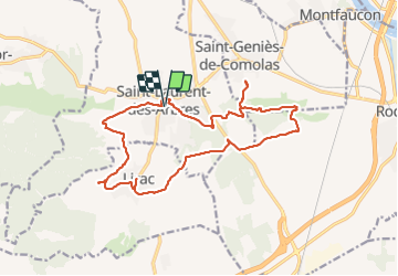
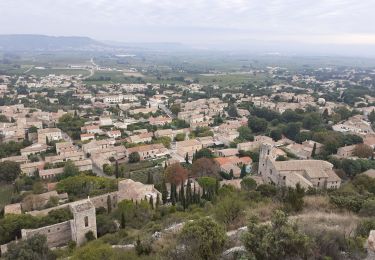
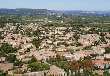
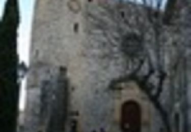
Tour Wandern von 18,8 km verfügbar auf Okzitanien, Gard, Saint-Laurent-des-Arbres. Diese Tour wird von Manoune vorgeschlagen.
Beschreibung
Départ parking de L'Aire de Jeux Alexis Martin.
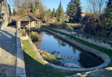
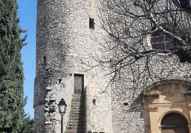
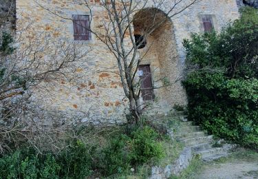
Rues Marcel Pagnol et la Montagnette, Lirac et son lavoir,traversée de la D 580 ( attention), le Devès, Lescarce, quitter le GR 42 à gauche ,chemin entre le vignes, rejoindre une petite route, la pendre à gauche et ensuite à droite pour monter sur la Montagne de St Geniés, PYl, à droite vers la Vierge De Comolas et retour, à droite ,suivre la piste pour arrivée à D 580 passer dessous celle-ci, continuer , passer une aire de pique- nique sur le GR 42, le Moulin Neuf, petite visite de St Laurent et retour au parking. ( bonne randonnée, il est possible de faire moins long).
Ort
Kommentare
Touren in der Umgebung
![Tour Wandern Saint-Laurent-des-Arbres - Les Vignobles de Lirac - Saint Laurent des Arbres - Photo](https://media.geolcdn.com/t/375/260/ext.jpg?maxdim=2&url=https%3A%2F%2Fservices.sitytrail.com%2FGeolivesWS%2FDownloadMedia.ashx%3FTrailID%3D317237%26Media%3D16416_6.jpg)
![Wandern Wandern](https://static1.geolcdn.com/sitytour/trail-icons/101.png)
Wandern
![](/images/other/stat-length.png)
![](https://static1.geolcdn.com/siteimages/upload/files/16400158638029165_repeat_loop_refresh_sync_direction_icon.png)
![Tour Wandern Lirac - rando des 4 lavoirs - Photo](https://media.geolcdn.com/t/375/260/b910313b-f40e-420b-9ddd-36236b127dfb.jpg&format=jpg&maxdim=2)
![Wandern Wandern](https://static1.geolcdn.com/sitytour/trail-icons/101.png)
![Tour Wandern Saint-Victor-la-Coste - Saint victor la coste 300323 - Photo](https://media.geolcdn.com/t/375/260/b12b695c-7275-4742-bf11-008804646dd6.jpg&format=jpg&maxdim=2)
![Wandern Wandern](https://static1.geolcdn.com/sitytour/trail-icons/101.png)
Wandern
![](/images/other/stat-length.png)
![](https://static1.geolcdn.com/siteimages/upload/files/16400158638029165_repeat_loop_refresh_sync_direction_icon.png)
![Tour Wandern Lirac - Le Tanargue - Photo](https://media.geolcdn.com/t/375/260/c76d9f19-ee2b-4749-87df-9221a92da648.jpg&format=jpg&maxdim=2)
![Wandern Wandern](https://static1.geolcdn.com/sitytour/trail-icons/101.png)
![Tour Wandern Saint-Victor-la-Coste - St Victor la Coste Goule de Navet - Photo](https://media.geolcdn.com/t/375/260/4895cb47-8177-4f48-bef5-74ca2af99397.jpg&format=jpg&maxdim=2)
![Wandern Wandern](https://static1.geolcdn.com/sitytour/trail-icons/101.png)
Wandern
![](/images/other/stat-length.png)
![](https://static1.geolcdn.com/siteimages/upload/files/16400158638029165_repeat_loop_refresh_sync_direction_icon.png)
![Tour Wandern Saint-Victor-la-Coste - Le Castellas de Saint Victor - Photo](https://media.geolcdn.com/t/375/260/ext.jpg?maxdim=2&url=https%3A%2F%2Fservices.sitytrail.com%2FGeolivesWS%2FDownloadMedia.ashx%3FTrailID%3D1040678%26Media%3Dfix__20180915142954.jpg)
![Wandern Wandern](https://static1.geolcdn.com/sitytour/trail-icons/101.png)
Wandern
![](/images/other/stat-length.png)
![](https://static1.geolcdn.com/siteimages/upload/files/16400158638029165_repeat_loop_refresh_sync_direction_icon.png)
![Tour Wandern Saint-Victor-la-Coste - Le Goule de Navet - St Victor la Coste - Photo](https://media.geolcdn.com/t/375/260/ext.jpg?maxdim=2&url=https%3A%2F%2Fservices.sitytrail.com%2FGeolivesWS%2FDownloadMedia.ashx%3FTrailID%3D317466%26Media%3D16701_6.jpg)
![Wandern Wandern](https://static1.geolcdn.com/sitytour/trail-icons/101.png)
Wandern
![](/images/other/stat-length.png)
![](https://static1.geolcdn.com/siteimages/upload/files/16400158638029165_repeat_loop_refresh_sync_direction_icon.png)
![Tour Wandern Saint-Victor-la-Coste - 30 - SAINT-VICTOR-LA-COSTE – NAVET - 13.6Km - 05h15 - D 340 m - Photo](https://media.geolcdn.com/t/375/260/ext.jpg?maxdim=2&url=https%3A%2F%2Fstatic1.geolcdn.com%2Fsiteimages%2Fupload%2Ffiles%2F1553511878bg_sport_marche.png)
![Wandern Wandern](https://static1.geolcdn.com/sitytour/trail-icons/101.png)
Wandern
![](/images/other/stat-length.png)
![](https://static1.geolcdn.com/siteimages/upload/files/16400158638029165_repeat_loop_refresh_sync_direction_icon.png)
![Tour Wandern Lirac - Lirac les 4 lavoirs - Photo](https://media.geolcdn.com/t/375/260/ab649616-d1f9-4afb-8474-39fcd12a40eb.jpg&format=jpg&maxdim=2)
![Wandern Wandern](https://static1.geolcdn.com/sitytour/trail-icons/101.png)
Wandern
![](/images/other/stat-length.png)
![](https://static1.geolcdn.com/siteimages/upload/files/16400158638029165_repeat_loop_refresh_sync_direction_icon.png)