![](/images/other/stat-length.png)
![Tour Reiten Viroinval - rando pour intermédiaire - Photo](https://media.geolcdn.com/t/1900/400/c0f570cc-20f0-491f-bb7b-342e4d59a088.jpg&format=pjpeg&maxdim=2)
rando pour intermédiaire
Ophélie Lhoir
Benutzer
![Länge](/images/other/stat-length.png)
Länge
12,9 km
![Maximale Höhe](https://static1.geolcdn.com/siteimages/upload/files/1508320355ic_sort_altitude_max_24dp.png)
Maximale Höhe
390 m
![Positive Höhendifferenz](https://static1.geolcdn.com/siteimages/upload/files/1508320355ic_sort_den_pos_24dp.png)
Positive Höhendifferenz
243 m
![Km-Effort](/images/other/stat-length.png)
Km-Effort
16,1 km
![Min. Höhe](https://static1.geolcdn.com/siteimages/upload/files/1508320355ic_sort_altitude_min_24dp.png)
Min. Höhe
273 m
![Negative Höhendifferenz](https://static1.geolcdn.com/siteimages/upload/files/1508320355ic_sort_den_neg_24dp.png)
Negative Höhendifferenz
239 m
![Boucle](https://static1.geolcdn.com/siteimages/upload/files/16400158638029165_repeat_loop_refresh_sync_direction_icon.png)
Boucle
Ja
Erstellungsdatum :
2021-09-11 13:52:09.522
Letzte Änderung :
2021-09-11 15:54:48.356
![Reiten](https://static1.geolcdn.com/sitytour/trail-icons/301.png)
1h32
Schwierigkeit : Medium
![Scannen Sie diesen QR-Code, um die Tour in der SityTrail-Anwendung zu öffnen](https://capi.geolives.com/qq0zvz2zws4bq2lad0pu/sitytour/trails/2932886/qr.png?size=200)
Kostenlosegpshiking-Anwendung
Über SityTrail
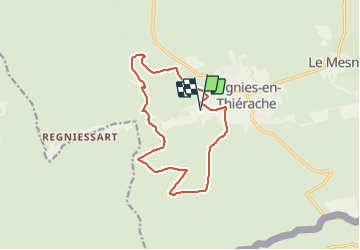
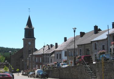
Tour Reiten von 12,9 km verfügbar auf Wallonien, Namur, Viroinval. Diese Tour wird von Ophélie Lhoir vorgeschlagen.
Beschreibung
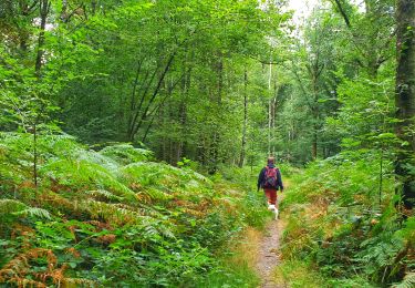
Beaux chemins de balade et quelques beaux galops. Beaucoup de forêts, un peu sur la domaniale et un peu sur le ravel, très peu de route (200 m à peine). Passage dans 2 ruisseau.
Ort
Land:
Belgium
Region :
Wallonien
Abteilung/Provinz :
Namur
Kommune :
Viroinval
Standort:
Unknown
Gehen Sie:(Dec)
Gehen Sie:(UTM)
616339 ; 5542209 (31U) N.
Kommentare
Touren in der Umgebung
![Wandern Wandern](https://static1.geolcdn.com/sitytour/trail-icons/101.png)
Le Trou du Diable à Oignies en Thiérache
Wandern
Sehr leicht
(4)
Viroinval,
Wallonien,
Namur,
Belgium
![](/images/other/stat-length.png)
6,4 km | 9,1 km-effort
2h 32min
![](https://static1.geolcdn.com/siteimages/upload/files/16400158638029165_repeat_loop_refresh_sync_direction_icon.png)
Ja
![Tour Wandern Viroinval - RF-Na-12 Oignies - Grande-boucle - Photo](https://media.geolcdn.com/t/375/260/ext.jpg?maxdim=2&url=https%3A%2F%2Fstatic1.geolcdn.com%2Fsiteimages%2Fupload%2Ffiles%2F1553511878bg_sport_marche.png)
![Wandern Wandern](https://static1.geolcdn.com/sitytour/trail-icons/101.png)
RF-Na-12 Oignies - Grande-boucle
Wandern
Medium
(1)
Viroinval,
Wallonien,
Namur,
Belgium
![](/images/other/stat-length.png)
11 km | 14,2 km-effort
3h 2min
![](https://static1.geolcdn.com/siteimages/upload/files/16400158638029165_repeat_loop_refresh_sync_direction_icon.png)
Ja
![Tour Wandern Viroinval - Balade à Le Mesnil - Viroinval - Photo](https://media.geolcdn.com/t/375/260/040808b9-fcd8-4fc3-8c4a-eb6f326e6772.jpeg&format=jpg&maxdim=2)
![Wandern Wandern](https://static1.geolcdn.com/sitytour/trail-icons/101.png)
Balade à Le Mesnil - Viroinval
Wandern
Einfach
Viroinval,
Wallonien,
Namur,
Belgium
![](/images/other/stat-length.png)
3,6 km | 4,8 km-effort
2h 16min
![](https://static1.geolcdn.com/siteimages/upload/files/16400158638029165_repeat_loop_refresh_sync_direction_icon.png)
Ja
![Tour Wandern Viroinval - 2024-03-19_14h55m08_OTH-A0-008T-2Z7M - Photo](https://media.geolcdn.com/t/375/260/3b9face2-c744-4af6-a62d-817b6f505d56.jpg&format=jpg&maxdim=2)
![Wandern Wandern](https://static1.geolcdn.com/sitytour/trail-icons/101.png)
2024-03-19_14h55m08_OTH-A0-008T-2Z7M
Wandern
Medium
Viroinval,
Wallonien,
Namur,
Belgium
![](/images/other/stat-length.png)
8,4 km | 11 km-effort
2h 29min
![](https://static1.geolcdn.com/siteimages/upload/files/16400158638029165_repeat_loop_refresh_sync_direction_icon.png)
Ja
![Tour Wandern Viroinval - Balade à Regniessart - Viroinval - Photo](https://media.geolcdn.com/t/375/260/a5d602e3-469f-47f0-b83f-6a311b5da224.jpeg&format=jpg&maxdim=2)
![Wandern Wandern](https://static1.geolcdn.com/sitytour/trail-icons/101.png)
Balade à Regniessart - Viroinval
Wandern
Medium
Viroinval,
Wallonien,
Namur,
Belgium
![](/images/other/stat-length.png)
8,4 km | 10,6 km-effort
2h 24min
![](https://static1.geolcdn.com/siteimages/upload/files/16400158638029165_repeat_loop_refresh_sync_direction_icon.png)
Ja
![Tour Wandern Viroinval - Balade à Oignies-en-Thiérache - Le Ry d'Alise - Photo](https://media.geolcdn.com/t/375/260/87d4fc47-9859-4088-b6f4-a15d14542517.jpeg&format=jpg&maxdim=2)
![Wandern Wandern](https://static1.geolcdn.com/sitytour/trail-icons/101.png)
Balade à Oignies-en-Thiérache - Le Ry d'Alise
Wandern
Medium
Viroinval,
Wallonien,
Namur,
Belgium
![](/images/other/stat-length.png)
8,6 km | 11,8 km-effort
2h 40min
![](https://static1.geolcdn.com/siteimages/upload/files/16400158638029165_repeat_loop_refresh_sync_direction_icon.png)
Ja
![Tour Zu Fuß Viroinval - Les Crêtes - Robertsart - Photo](https://media.geolcdn.com/t/375/260/95bd997e-996f-450d-98b8-1f50f91ce91a.jpeg&format=jpg&maxdim=2)
![Zu Fuß Zu Fuß](https://static1.geolcdn.com/sitytour/trail-icons/100.png)
Les Crêtes - Robertsart
Zu Fuß
Einfach
Viroinval,
Wallonien,
Namur,
Belgium
![](/images/other/stat-length.png)
9,9 km | 13,6 km-effort
3h 5min
![](https://static1.geolcdn.com/siteimages/upload/files/16400158638029165_repeat_loop_refresh_sync_direction_icon.png)
Ja
![Tour Zu Fuß Viroinval - Les Bornes - Photo](https://media.geolcdn.com/t/375/260/017373ad-a55f-4063-a87f-c762cd7880fd.jpeg&format=jpg&maxdim=2)
![Zu Fuß Zu Fuß](https://static1.geolcdn.com/sitytour/trail-icons/100.png)
![Tour Zu Fuß Viroinval - Le Centre de l'Europe des 15 - Photo](https://media.geolcdn.com/t/375/260/1a7c1b9a-14f4-4ae7-af17-534dfbd74e08.jpeg&format=jpg&maxdim=2)
![Zu Fuß Zu Fuß](https://static1.geolcdn.com/sitytour/trail-icons/100.png)
Le Centre de l'Europe des 15
Zu Fuß
Einfach
Viroinval,
Wallonien,
Namur,
Belgium
![](/images/other/stat-length.png)
14,1 km | 19,4 km-effort
4h 25min
![](https://static1.geolcdn.com/siteimages/upload/files/16400158638029165_repeat_loop_refresh_sync_direction_icon.png)
Nein