


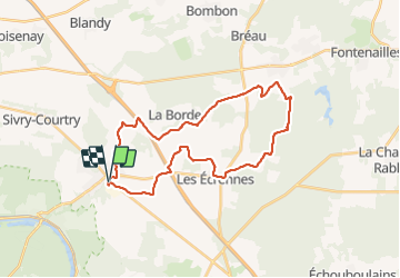

28 km | 32 km-effort

Benutzer GUIDE


Kostenlosegpshiking-Anwendung
 SityTrail
IGN / Geografische Institute
SityTrail World
Die Welt öffnet sich für Sie
Tour Wandern von 29 km verfügbar auf Île-de-France, Seine-et-Marne, Le Châtelet-en-Brie. Diese Tour wird von chessyca vorgeschlagen.
Boucle sans difficulté côté terrain mais rendue difficile par le climat du jour . 32-33 degré
Beaucoup de passages en plein cagnard sans possibilité de s'abriter .


Wandern
Wandern

Wandern

Wandern
Wandern

Laufen

Zu Fuß

Wandern

Fahrrad