![](/images/other/stat-length.png)
![Tour Mountainbike Wirten - Lahage II - Balade_VTT_33Kms - Photo](https://media.geolcdn.com/t/1900/400/5c233df8-5164-4eb9-bf3f-b82398dbc5b8.jpg&format=pjpeg&maxdim=2)
Lahage II - Balade_VTT_33Kms
Pascal L
Benutzer
![Länge](/images/other/stat-length.png)
![Maximale Höhe](https://static1.geolcdn.com/siteimages/upload/files/1508320355ic_sort_altitude_max_24dp.png)
![Positive Höhendifferenz](https://static1.geolcdn.com/siteimages/upload/files/1508320355ic_sort_den_pos_24dp.png)
![Km-Effort](/images/other/stat-length.png)
![Min. Höhe](https://static1.geolcdn.com/siteimages/upload/files/1508320355ic_sort_altitude_min_24dp.png)
![Negative Höhendifferenz](https://static1.geolcdn.com/siteimages/upload/files/1508320355ic_sort_den_neg_24dp.png)
![Boucle](https://static1.geolcdn.com/siteimages/upload/files/16400158638029165_repeat_loop_refresh_sync_direction_icon.png)
![Mountainbike](https://static1.geolcdn.com/sitytour/trail-icons/202.png)
3h00
Schwierigkeit : Schwierig
![Scannen Sie diesen QR-Code, um die Tour in der SityTrail-Anwendung zu öffnen](https://capi.geolives.com/qq0zvz2zws4bq2lad0pu/sitytour/trails/2923201/qr.png?size=200)
Kostenlosegpshiking-Anwendung
Über SityTrail
Tour Mountainbike von 33 km verfügbar auf Wallonien, Luxemburg, Wirten. Diese Tour wird von Pascal L vorgeschlagen.
Beschreibung
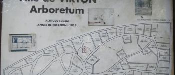
Départ/Retour: Virton (Val d'Away - Breda)
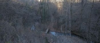
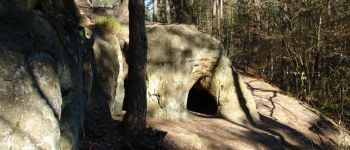
Endroits de passage : Houdrigny, Chaufour, Lampré, le Bochet de la Michette, Ferme du Hayon, Croix Jean de Paris, Gérouville (vue), Ferme de la Barrière, Bois de Nichansart (Meix-devant-Virton), la Cranière (Gros Cron), les Aisances de Bellefontaine, la Chevratte, Lahage, ruisseau et moulin de Lahage, Bois le Trite, ruisseau de la Saint Jean, le Posson, Bois de Virton, Repaire des Zigomars, Fontaine de la Mère-Dieu, Sentier des Songes, Ruisseau et vallée de Rabais, Fagne Pierrard
La Bergerie du Gros Cron : https://www.facebook.com/labergeriedugroscron/
Vidéo (point de vue sur Gérouville): https://vimeo.com/763538339
(2021.09.03)
Ort
Kommentare
Touren in der Umgebung
![Tour Wandern Wirten - RB-Lu-17_Ethe_via-var-1-et-2-et-3 - Photo](https://media.geolcdn.com/t/375/260/ext.jpg?maxdim=2&url=https%3A%2F%2Fservices.sitytrail.com%2FGeolivesWS%2FDownloadMedia.ashx%3FTrailID%3D541328%26Media%3Df1aeb673-5eb3-40d2-9e3e-9751bd16961f.jpg)
![Wandern Wandern](https://static1.geolcdn.com/sitytour/trail-icons/101.png)
Wandern
![](/images/other/stat-length.png)
![](https://static1.geolcdn.com/siteimages/upload/files/16400158638029165_repeat_loop_refresh_sync_direction_icon.png)
![Tour Mountainbike Wirten - T2019-06-16-16-47 - Photo](https://media.geolcdn.com/t/375/260/7f02a860-4654-49bb-aa49-fc1e5df64440.jpg&format=jpg&maxdim=2)
![Mountainbike Mountainbike](https://static1.geolcdn.com/sitytour/trail-icons/202.png)
Mountainbike
![](/images/other/stat-length.png)
![](https://static1.geolcdn.com/siteimages/upload/files/16400158638029165_repeat_loop_refresh_sync_direction_icon.png)
![Tour Wandern Wirten - GAUME Balade naturelle et historique - Photo](https://media.geolcdn.com/t/375/260/ext.jpg?maxdim=2&url=https%3A%2F%2Fservices.sitytrail.com%2FGeolivesWS%2FDownloadMedia.ashx%3FTrailID%3D164521%26Media%3D20121125163840.jpeg)
![Wandern Wandern](https://static1.geolcdn.com/sitytour/trail-icons/101.png)
Wandern
![](/images/other/stat-length.png)
![](https://static1.geolcdn.com/siteimages/upload/files/16400158638029165_repeat_loop_refresh_sync_direction_icon.png)
![Tour Zu Fuß Wirten - La Bajocienne - Photo](https://media.geolcdn.com/t/375/260/ext.jpg?maxdim=2&url=https%3A%2F%2Fpivotmedia.tourismewallonie.be%2FOTH-A0-006F-3DH1%2FOTH-A0-006F-3DH1.jpg)
![Zu Fuß Zu Fuß](https://static1.geolcdn.com/sitytour/trail-icons/100.png)
Zu Fuß
![](/images/other/stat-length.png)
![](https://static1.geolcdn.com/siteimages/upload/files/16400158638029165_repeat_loop_refresh_sync_direction_icon.png)
![Tour Wandern Wirten - RB-Lu-17_Ethe_via-racc - Photo](https://media.geolcdn.com/t/375/260/ext.jpg?maxdim=2&url=https%3A%2F%2Fservices.sitytrail.com%2FGeolivesWS%2FDownloadMedia.ashx%3FTrailID%3D541324%26Media%3Df9f14959-9764-4ab9-b216-8ff20ce6d698.jpg)
![Wandern Wandern](https://static1.geolcdn.com/sitytour/trail-icons/101.png)
Wandern
![](/images/other/stat-length.png)
![](https://static1.geolcdn.com/siteimages/upload/files/16400158638029165_repeat_loop_refresh_sync_direction_icon.png)
![Tour Wandern Wirten - RB-Lu-17_Ethe - Photo](https://media.geolcdn.com/t/375/260/ext.jpg?maxdim=2&url=https%3A%2F%2Fservices.sitytrail.com%2FGeolivesWS%2FDownloadMedia.ashx%3FTrailID%3D541324%26Media%3D8965deff-6975-4e3c-a1d0-87e46c5ff193.jpg)
![Wandern Wandern](https://static1.geolcdn.com/sitytour/trail-icons/101.png)
Wandern
![](/images/other/stat-length.png)
![](https://static1.geolcdn.com/siteimages/upload/files/16400158638029165_repeat_loop_refresh_sync_direction_icon.png)
![Tour Mountainbike Wirten - Autour de Tintigny - Balade_VTT_54Kms - Photo](https://media.geolcdn.com/t/375/260/f2991960-98bf-4ded-84b3-f3460299ceba.jpg&format=jpg&maxdim=2)
![Mountainbike Mountainbike](https://static1.geolcdn.com/sitytour/trail-icons/202.png)
Mountainbike
![](/images/other/stat-length.png)
![](https://static1.geolcdn.com/siteimages/upload/files/16400158638029165_repeat_loop_refresh_sync_direction_icon.png)
![Tour Mountainbike Wirten - Monquintin - Balade_VTT_22Kms - Photo](https://media.geolcdn.com/t/375/260/136209b8-b776-4094-a6b1-d92770fe7c94.jpg&format=jpg&maxdim=2)
![Mountainbike Mountainbike](https://static1.geolcdn.com/sitytour/trail-icons/202.png)
Mountainbike
![](/images/other/stat-length.png)
![](https://static1.geolcdn.com/siteimages/upload/files/16400158638029165_repeat_loop_refresh_sync_direction_icon.png)
![Tour Mountainbike Wirten - Orval - Balade_VTT_50Kms - Photo](https://media.geolcdn.com/t/375/260/1aeac739-ad2c-44a6-9d1f-617a984d021d.jpg&format=jpg&maxdim=2)
![Mountainbike Mountainbike](https://static1.geolcdn.com/sitytour/trail-icons/202.png)
Mountainbike
![](/images/other/stat-length.png)
![](https://static1.geolcdn.com/siteimages/upload/files/16400158638029165_repeat_loop_refresh_sync_direction_icon.png)