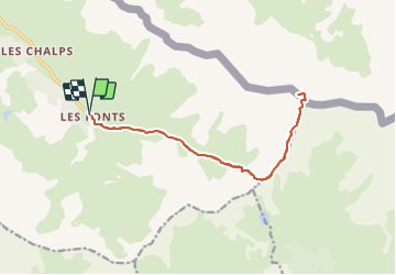
![](/images/other/stat-length.png)
![Tour Wandern Cervières - Le Grand Gleiza - Photo](https://media.geolcdn.com/t/1900/400/ext.pjpeg?maxdim=2&url=https%3A%2F%2Fstatic1.geolcdn.com%2Fsiteimages%2Fupload%2Ffiles%2F1553511878bg_sport_marche.png)
Le Grand Gleiza
Dervalmarc
Benutzer
![Länge](/images/other/stat-length.png)
![Maximale Höhe](https://static1.geolcdn.com/siteimages/upload/files/1508320355ic_sort_altitude_max_24dp.png)
![Positive Höhendifferenz](https://static1.geolcdn.com/siteimages/upload/files/1508320355ic_sort_den_pos_24dp.png)
![Km-Effort](/images/other/stat-length.png)
![Min. Höhe](https://static1.geolcdn.com/siteimages/upload/files/1508320355ic_sort_altitude_min_24dp.png)
![Negative Höhendifferenz](https://static1.geolcdn.com/siteimages/upload/files/1508320355ic_sort_den_neg_24dp.png)
![Boucle](https://static1.geolcdn.com/siteimages/upload/files/16400158638029165_repeat_loop_refresh_sync_direction_icon.png)
![Wandern](https://static1.geolcdn.com/sitytour/trail-icons/101.png)
22h34
Schwierigkeit : Sehr schwierig
![Scannen Sie diesen QR-Code, um die Tour in der SityTrail-Anwendung zu öffnen](https://capi.geolives.com/qq0zvz2zws4bq2lad0pu/sitytour/trails/2914264/qr.png?size=200)
Kostenlosegpshiking-Anwendung
Über SityTrail
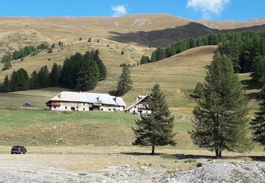
Tour Wandern von 15,8 km verfügbar auf Provence-Alpes-Côte d'Azur, Hochalpen, Cervières. Diese Tour wird von Dervalmarc vorgeschlagen.
Beschreibung
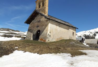
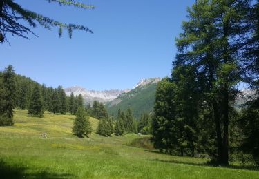
Très longue randonnée.
20 kilomètres.
Très variée.2 cimes, deux col.
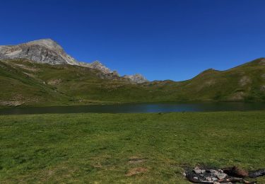
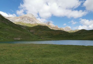
Vue sur le grand lac du Laus.
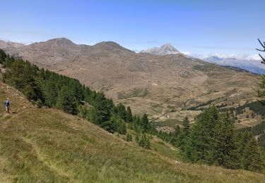
Compter entre huit et 10 heures de marche arrêts non compris.
Panorama exceptionnel bien mérité après une ascension exigeante.
Compter 10h de marche et non 22h37
Ort
Kommentare
Touren in der Umgebung
![Tour Wandern Cervières - Le Petit rochebrune par col de péas - Photo](https://media.geolcdn.com/t/375/260/e12553c6-5b67-4a21-b5b9-83e83e9c9741.jpg&format=jpg&maxdim=2)
![Wandern Wandern](https://static1.geolcdn.com/sitytour/trail-icons/101.png)
Wandern
![](/images/other/stat-length.png)
![](https://static1.geolcdn.com/siteimages/upload/files/16400158638029165_repeat_loop_refresh_sync_direction_icon.png)
![Tour Wandern Cervières - le lac des Cordes et le pic du vallon Crouzet - Photo](https://media.geolcdn.com/t/375/260/ext.jpg?maxdim=2&url=https%3A%2F%2Fservices.sitytrail.com%2FGeolivesWS%2FDownloadMedia.ashx%3FTrailID%3D787861%26Media%3Dfix__20170710153913.jpg)
![Wandern Wandern](https://static1.geolcdn.com/sitytour/trail-icons/101.png)
Wandern
![](/images/other/stat-length.png)
![](https://static1.geolcdn.com/siteimages/upload/files/16400158638029165_repeat_loop_refresh_sync_direction_icon.png)
![Tour Wandern Cervières - Circuit du Lac des Cordes - Photo](https://media.geolcdn.com/t/375/260/773a9233-b719-442d-b7b1-75196ce74f87.jpg&format=jpg&maxdim=2)
![Wandern Wandern](https://static1.geolcdn.com/sitytour/trail-icons/101.png)
Wandern
![](/images/other/stat-length.png)
![](https://static1.geolcdn.com/siteimages/upload/files/16400158638029165_repeat_loop_refresh_sync_direction_icon.png)
![Tour Skiwanderen Cervières - PT 2944 crête de Dormillouse - Photo](https://media.geolcdn.com/t/375/260/9199c634-7f71-48f6-bcd5-441d1eaab9cb.jpg&format=jpg&maxdim=2)
![Skiwanderen Skiwanderen](https://static1.geolcdn.com/sitytour/trail-icons/503.png)
Skiwanderen
![](/images/other/stat-length.png)
![](https://static1.geolcdn.com/siteimages/upload/files/16400158638029165_repeat_loop_refresh_sync_direction_icon.png)
![Tour Wandern Cervières - le lasseron col de chaude maison - Photo](https://media.geolcdn.com/t/375/260/a0498023-fd7f-45a6-ba40-c354c806ca60.jpg&format=jpg&maxdim=2)
![Wandern Wandern](https://static1.geolcdn.com/sitytour/trail-icons/101.png)
Wandern
![](/images/other/stat-length.png)
![](https://static1.geolcdn.com/siteimages/upload/files/16400158638029165_repeat_loop_refresh_sync_direction_icon.png)
![Tour Wandern Cervières - Le Lac des cordes - Photo](https://media.geolcdn.com/t/375/260/4677ed4c-abf4-4114-9dfd-57192ba7a290.jpg&format=jpg&maxdim=2)
![Wandern Wandern](https://static1.geolcdn.com/sitytour/trail-icons/101.png)
Wandern
![](/images/other/stat-length.png)
![](https://static1.geolcdn.com/siteimages/upload/files/16400158638029165_repeat_loop_refresh_sync_direction_icon.png)
![Tour Wandern Cervières - Arsem Les fonts de Cervieres - Photo](https://media.geolcdn.com/t/375/260/1c663feb-cf6d-4c05-adc4-11e78d8381cd.jpg&format=jpg&maxdim=2)
![Wandern Wandern](https://static1.geolcdn.com/sitytour/trail-icons/101.png)
Wandern
![](/images/other/stat-length.png)
![](https://static1.geolcdn.com/siteimages/upload/files/16400158638029165_repeat_loop_refresh_sync_direction_icon.png)
![Tour Schlittenfahren Cervières - refuge Les Fonts à Chalp - Photo](https://media.geolcdn.com/t/375/260/1095cc6d-0fa6-427a-8540-75f35ae6c8dc.jpg&format=jpg&maxdim=2)
![Schlittenfahren Schlittenfahren](https://static1.geolcdn.com/sitytour/trail-icons/506.png)
Schlittenfahren
![](/images/other/stat-length.png)
![](https://static1.geolcdn.com/siteimages/upload/files/16400158638029165_repeat_loop_refresh_sync_direction_icon.png)
![Tour Wandern Cervières - Lac des Cordes - Photo](https://media.geolcdn.com/t/375/260/89c8f3fc-bf2f-4ed0-a763-182170a8be7f.jpg&format=jpg&maxdim=2)
![Wandern Wandern](https://static1.geolcdn.com/sitytour/trail-icons/101.png)
Wandern
![](/images/other/stat-length.png)
![](https://static1.geolcdn.com/siteimages/upload/files/16400158638029165_repeat_loop_refresh_sync_direction_icon.png)