![](/images/other/stat-length.png)
![Tour Wandern Bourg-Saint-Maurice - Col de Seigne - Photo](https://media.geolcdn.com/t/1900/400/63610327-66f4-46b0-9c2e-7a86da45bce8.jpg&format=pjpeg&maxdim=2)
Col de Seigne
Hugues Michel
Benutzer
![Länge](/images/other/stat-length.png)
![Maximale Höhe](https://static1.geolcdn.com/siteimages/upload/files/1508320355ic_sort_altitude_max_24dp.png)
![Positive Höhendifferenz](https://static1.geolcdn.com/siteimages/upload/files/1508320355ic_sort_den_pos_24dp.png)
![Km-Effort](/images/other/stat-length.png)
![Min. Höhe](https://static1.geolcdn.com/siteimages/upload/files/1508320355ic_sort_altitude_min_24dp.png)
![Negative Höhendifferenz](https://static1.geolcdn.com/siteimages/upload/files/1508320355ic_sort_den_neg_24dp.png)
![Boucle](https://static1.geolcdn.com/siteimages/upload/files/16400158638029165_repeat_loop_refresh_sync_direction_icon.png)
![Wandern](https://static1.geolcdn.com/sitytour/trail-icons/101.png)
3h01
Schwierigkeit : Schwierig
![Scannen Sie diesen QR-Code, um die Tour in der SityTrail-Anwendung zu öffnen](https://capi.geolives.com/qq0zvz2zws4bq2lad0pu/sitytour/trails/2906604/qr.png?size=200)
Kostenlosegpshiking-Anwendung
Über SityTrail
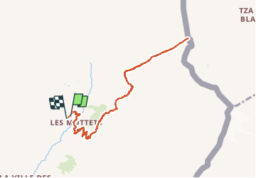
Tour Wandern von 10,1 km verfügbar auf Auvergne-Rhone-Alpen, Savoyen, Bourg-Saint-Maurice. Diese Tour wird von Hugues Michel vorgeschlagen.
Beschreibung
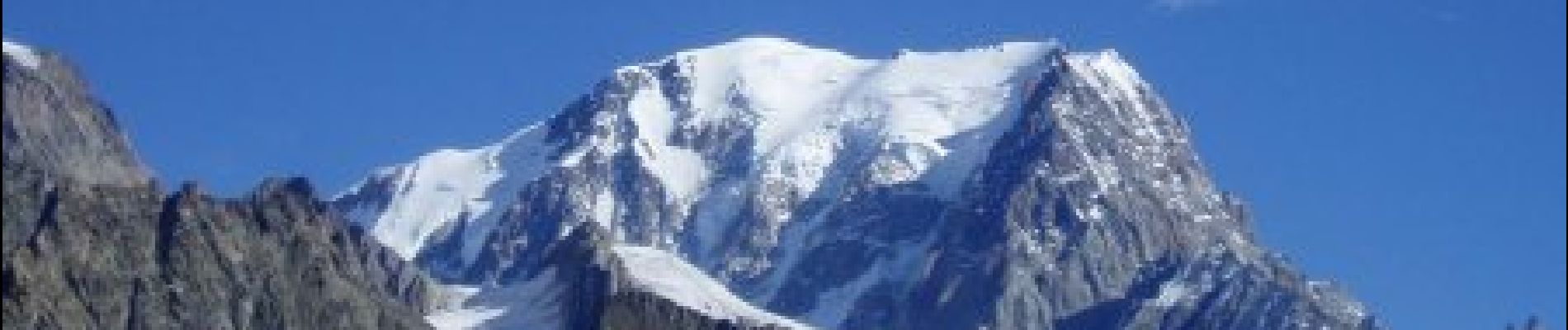
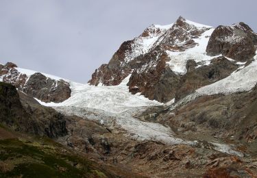
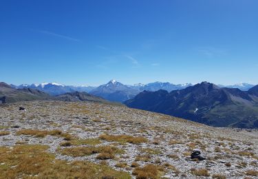
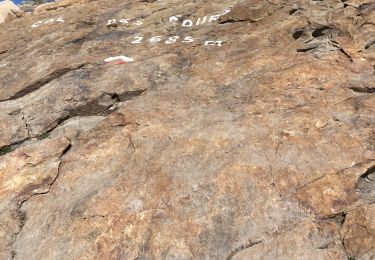
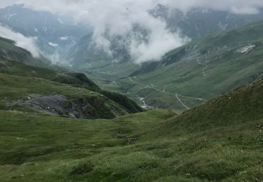
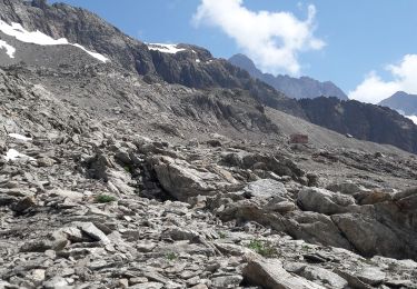
Au départ de la vallée des Chapieux, prendre la navette jusqu'aux parking des Mottets. On se dirige ensuite jusqu'à la frontière franco-italienne, au Col de la Seigne à 2516m. Lors de la montée vue sur l'aiguille des Glaciers. A l'arrivée, vue imprenable sur le Mont-Blanc côté italien.
Ort
Kommentare
Touren in der Umgebung
![Tour Wandern Bourg-Saint-Maurice - suuntoapp-Hiking-2024-09-10T06-18-18Z - Photo](https://media.geolcdn.com/t/375/260/2ffa221c-2b68-468e-ba02-fb43d145165a.jpg&format=jpg&maxdim=2)
![Wandern Wandern](https://static1.geolcdn.com/sitytour/trail-icons/101.png)
Wandern
![](/images/other/stat-length.png)
![](https://static1.geolcdn.com/siteimages/upload/files/16400158638029165_repeat_loop_refresh_sync_direction_icon.png)
![Tour Skiwanderen Bourg-Saint-Maurice - autour du lac de Mya - Photo](https://media.geolcdn.com/t/375/260/4ac04904-2253-423b-b6ac-3f3b6564cfe2.jpg&format=jpg&maxdim=2)
![Skiwanderen Skiwanderen](https://static1.geolcdn.com/sitytour/trail-icons/503.png)
Skiwanderen
![](/images/other/stat-length.png)
![](https://static1.geolcdn.com/siteimages/upload/files/16400158638029165_repeat_loop_refresh_sync_direction_icon.png)
![Tour Zu Fuß Courmayeur - Alta Via n. 2 della Valle d'Aosta - Tappa 2 - Photo](https://media.geolcdn.com/t/375/260/1a96e093-87d3-42ba-8bbf-a0f169e367d1.jpeg&format=jpg&maxdim=2)
![Zu Fuß Zu Fuß](https://static1.geolcdn.com/sitytour/trail-icons/100.png)
Zu Fuß
![](/images/other/stat-length.png)
![](https://static1.geolcdn.com/siteimages/upload/files/16400158638029165_repeat_loop_refresh_sync_direction_icon.png)
![Tour Zu Fuß Courmayeur - (SI F07) Rifugio Elisabetta - Courmayeur - Photo](https://media.geolcdn.com/t/375/260/08d2089a-21fe-43f9-b227-bb1850f9ac87.jpeg&format=jpg&maxdim=2)
![Zu Fuß Zu Fuß](https://static1.geolcdn.com/sitytour/trail-icons/100.png)
Zu Fuß
![](/images/other/stat-length.png)
![](https://static1.geolcdn.com/siteimages/upload/files/16400158638029165_repeat_loop_refresh_sync_direction_icon.png)
![Tour Wandern Bourg-Saint-Maurice - le lac de Mya, le col des Fours et la tête sud des Fours - Photo](https://media.geolcdn.com/t/375/260/24e734a8-cdba-440c-a390-09e59e7aa7ec.jpg&format=jpg&maxdim=2)
![Wandern Wandern](https://static1.geolcdn.com/sitytour/trail-icons/101.png)
Wandern
![](/images/other/stat-length.png)
![](https://static1.geolcdn.com/siteimages/upload/files/16400158638029165_repeat_loop_refresh_sync_direction_icon.png)
![Tour Wandern Bourg-Saint-Maurice - Les chapieux-col des four - Photo](https://media.geolcdn.com/t/375/260/95a94c92-2d9f-4b93-87c7-1335119f6081.jpeg&format=jpg&maxdim=2)
![Wandern Wandern](https://static1.geolcdn.com/sitytour/trail-icons/101.png)
Wandern
![](/images/other/stat-length.png)
![](https://static1.geolcdn.com/siteimages/upload/files/16400158638029165_repeat_loop_refresh_sync_direction_icon.png)
![Tour Wandern Bourg-Saint-Maurice - Le refuge de La Croix du bonhomme Elisabetta soldoni - Photo](https://media.geolcdn.com/t/375/260/178659b1-34e1-4857-a5f1-0282bf0768cc.jpg&format=jpg&maxdim=2)
![Wandern Wandern](https://static1.geolcdn.com/sitytour/trail-icons/101.png)
Wandern
![](/images/other/stat-length.png)
![](https://static1.geolcdn.com/siteimages/upload/files/16400158638029165_repeat_loop_refresh_sync_direction_icon.png)
![Tour Wandern Les Contamines-Montjoie - Beaufortain: Autour de La Pierra Menta: J4 - Ref du Col du Bonhomme - Gite de Plan Mya - Photo](https://media.geolcdn.com/t/375/260/8679ea84-1934-4c7b-a278-c54407d8c5c5.jpg&format=jpg&maxdim=2)
![Wandern Wandern](https://static1.geolcdn.com/sitytour/trail-icons/101.png)
Wandern
![](/images/other/stat-length.png)
![](https://static1.geolcdn.com/siteimages/upload/files/16400158638029165_repeat_loop_refresh_sync_direction_icon.png)
![Tour Wandern Bourg-Saint-Maurice - les Lanchettes refuge Robert Blanc - Photo](https://media.geolcdn.com/t/375/260/dffd4f94-01cd-45a7-9114-d414b27208e5.jpg&format=jpg&maxdim=2)
![Wandern Wandern](https://static1.geolcdn.com/sitytour/trail-icons/101.png)
Wandern
![](/images/other/stat-length.png)
![](https://static1.geolcdn.com/siteimages/upload/files/16400158638029165_repeat_loop_refresh_sync_direction_icon.png)