![](/images/other/stat-length.png)
![Tour Rennrad Saint-Gildas-de-Rhuys - kfg2021 08 18 - Photo](https://media.geolcdn.com/t/1900/400/ext.pjpeg?maxdim=2&url=https%3A%2F%2Fstatic1.geolcdn.com%2Fsiteimages%2Fupload%2Ffiles%2F1524743154velo.jpg)
kfg2021 08 18
berhin
Benutzer
![Länge](/images/other/stat-length.png)
Länge
28 km
![Maximale Höhe](https://static1.geolcdn.com/siteimages/upload/files/1508320355ic_sort_altitude_max_24dp.png)
Maximale Höhe
46 m
![Positive Höhendifferenz](https://static1.geolcdn.com/siteimages/upload/files/1508320355ic_sort_den_pos_24dp.png)
Positive Höhendifferenz
224 m
![Km-Effort](/images/other/stat-length.png)
Km-Effort
31 km
![Min. Höhe](https://static1.geolcdn.com/siteimages/upload/files/1508320355ic_sort_altitude_min_24dp.png)
Min. Höhe
-1 m
![Negative Höhendifferenz](https://static1.geolcdn.com/siteimages/upload/files/1508320355ic_sort_den_neg_24dp.png)
Negative Höhendifferenz
224 m
![Boucle](https://static1.geolcdn.com/siteimages/upload/files/16400158638029165_repeat_loop_refresh_sync_direction_icon.png)
Boucle
Ja
Erstellungsdatum :
2021-08-18 15:17:42.666
Letzte Änderung :
2021-08-18 18:46:05.185
![Rennrad](https://static1.geolcdn.com/sitytour/trail-icons/201.png)
3h08
Schwierigkeit : Medium
![Scannen Sie diesen QR-Code, um die Tour in der SityTrail-Anwendung zu öffnen](https://capi.geolives.com/qq0zvz2zws4bq2lad0pu/sitytour/trails/2903805/qr.png?size=200)
Kostenlosegpshiking-Anwendung
Über SityTrail
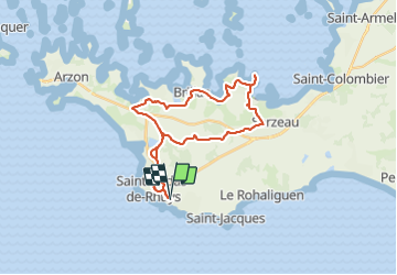
Tour Rennrad von 28 km verfügbar auf Bretagne, Morbihan, Saint-Gildas-de-Rhuys. Diese Tour wird von berhin vorgeschlagen.
Beschreibung
Sophie et Pierre
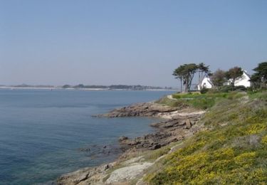
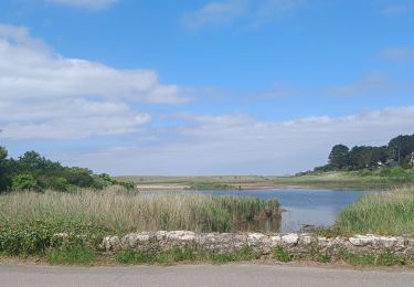
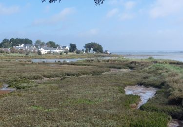
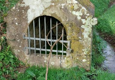
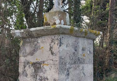
Ce mercredi 18/08/2021, nous sommes allé à Sarzeau par le circuit vélo. Nous sommes passé à la pointe de Benance puis retour par Fournevay, Brillac, Le Net.... Kerfago 25 Km
17H - 20H30
Ort
Land:
France
Region :
Bretagne
Abteilung/Provinz :
Morbihan
Kommune :
Saint-Gildas-de-Rhuys
Standort:
Unknown
Gehen Sie:(Dec)
Gehen Sie:(UTM)
512831 ; 5260328 (30T) N.
Kommentare
Touren in der Umgebung
![Tour Wandern Arzon - Tour du Golfe - Arzon - Photo](https://media.geolcdn.com/t/375/260/ext.jpg?maxdim=2&url=https%3A%2F%2Fservices.sitytrail.com%2FGeolivesWS%2FDownloadMedia.ashx%3FTrailID%3D107071%26Media%3D11890_2.jpg)
![Wandern Wandern](https://static1.geolcdn.com/sitytour/trail-icons/101.png)
Tour du Golfe - Arzon
Wandern
Medium
(1)
Arzon,
Bretagne,
Morbihan,
France
![](/images/other/stat-length.png)
18,2 km | 20 km-effort
4h 30min
![](https://static1.geolcdn.com/siteimages/upload/files/16400158638029165_repeat_loop_refresh_sync_direction_icon.png)
Ja
![Tour Wandern Sarzeau - Sarzeau Saint Jacques - Saint Gildas de Rhuys - Photo](https://media.geolcdn.com/t/375/260/ext.jpg?maxdim=2&url=https%3A%2F%2Fstatic1.geolcdn.com%2Fsiteimages%2Fupload%2Ffiles%2F1553511878bg_sport_marche.png)
![Wandern Wandern](https://static1.geolcdn.com/sitytour/trail-icons/101.png)
Sarzeau Saint Jacques - Saint Gildas de Rhuys
Wandern
Einfach
(1)
Sarzeau,
Bretagne,
Morbihan,
France
![](/images/other/stat-length.png)
14,9 km | 16,4 km-effort
3h 38min
![](https://static1.geolcdn.com/siteimages/upload/files/16400158638029165_repeat_loop_refresh_sync_direction_icon.png)
Ja
![Tour Wandern Sarzeau - Pointes de Bernon et de l'Ours - Photo](https://media.geolcdn.com/t/375/260/ext.jpg?maxdim=2&url=https%3A%2F%2Fstatic1.geolcdn.com%2Fsiteimages%2Fupload%2Ffiles%2F1553511878bg_sport_marche.png)
![Wandern Wandern](https://static1.geolcdn.com/sitytour/trail-icons/101.png)
Pointes de Bernon et de l'Ours
Wandern
Medium
(2)
Sarzeau,
Bretagne,
Morbihan,
France
![](/images/other/stat-length.png)
9,6 km | 10,8 km-effort
2h 22min
![](https://static1.geolcdn.com/siteimages/upload/files/16400158638029165_repeat_loop_refresh_sync_direction_icon.png)
Ja
![Tour Wandern Sarzeau - Circuit du Château de Truscat - Photo](https://media.geolcdn.com/t/375/260/ext.jpg?maxdim=2&url=https%3A%2F%2Fstatic1.geolcdn.com%2Fsiteimages%2Fupload%2Ffiles%2F1553511878bg_sport_marche.png)
![Wandern Wandern](https://static1.geolcdn.com/sitytour/trail-icons/101.png)
Circuit du Château de Truscat
Wandern
Einfach
(1)
Sarzeau,
Bretagne,
Morbihan,
France
![](/images/other/stat-length.png)
7,4 km | 8,2 km-effort
1h 50min
![](https://static1.geolcdn.com/siteimages/upload/files/16400158638029165_repeat_loop_refresh_sync_direction_icon.png)
Ja
![Tour Andere Aktivitäten Saint-Gildas-de-Rhuys - Houat 1 - Photo](https://media.geolcdn.com/t/375/260/ext.jpg?maxdim=2&url=https%3A%2F%2Fstatic1.geolcdn.com%2Fsiteimages%2Fupload%2Ffiles%2F1545311037marcheuse_200dpi.jpg)
![Andere Aktivitäten Andere Aktivitäten](https://static1.geolcdn.com/sitytour/trail-icons/900.png)
Houat 1
Andere Aktivitäten
Sehr leicht
(1)
Saint-Gildas-de-Rhuys,
Bretagne,
Morbihan,
France
![](/images/other/stat-length.png)
18,2 km | 18,7 km-effort
4h 15min
![](https://static1.geolcdn.com/siteimages/upload/files/16400158638029165_repeat_loop_refresh_sync_direction_icon.png)
Nein
![Tour Wandern Saint-Gildas-de-Rhuys - PR_56_St-Gildas-Rhuys_BA_02_Circuit1b_Les-Etangs_20240602 - Photo](https://media.geolcdn.com/t/375/260/c32a814c-43f5-42d3-9319-bc45835ee10e.jpg&format=jpg&maxdim=2)
![Wandern Wandern](https://static1.geolcdn.com/sitytour/trail-icons/101.png)
PR_56_St-Gildas-Rhuys_BA_02_Circuit1b_Les-Etangs_20240602
Wandern
Sehr leicht
Saint-Gildas-de-Rhuys,
Bretagne,
Morbihan,
France
![](/images/other/stat-length.png)
12,9 km | 14,3 km-effort
3h 14min
![](https://static1.geolcdn.com/siteimages/upload/files/16400158638029165_repeat_loop_refresh_sync_direction_icon.png)
Ja
![Tour Wandern Sarzeau - PR_56_Sarzeau_HA_08_Circuit1b_Les-Parcs-Ostreicoles_20240407 - Photo](https://media.geolcdn.com/t/375/260/aeca3880-48e4-4511-b52f-e7eaa46b5ea1.jpg&format=jpg&maxdim=2)
![Wandern Wandern](https://static1.geolcdn.com/sitytour/trail-icons/101.png)
PR_56_Sarzeau_HA_08_Circuit1b_Les-Parcs-Ostreicoles_20240407
Wandern
Sehr leicht
Sarzeau,
Bretagne,
Morbihan,
France
![](/images/other/stat-length.png)
8,2 km | 9,2 km-effort
2h 5min
![](https://static1.geolcdn.com/siteimages/upload/files/16400158638029165_repeat_loop_refresh_sync_direction_icon.png)
Ja
![Tour Wandern Arzon - PR_56_Arzon_BA_02_Circuit1b_La-Butte-De-Cesar_20240217 - Photo](https://media.geolcdn.com/t/375/260/527a5208-339c-4312-a6b8-52ed6b62652b.jpg&format=jpg&maxdim=2)
![Wandern Wandern](https://static1.geolcdn.com/sitytour/trail-icons/101.png)
PR_56_Arzon_BA_02_Circuit1b_La-Butte-De-Cesar_20240217
Wandern
Sehr leicht
Arzon,
Bretagne,
Morbihan,
France
![](/images/other/stat-length.png)
5,9 km | 6,5 km-effort
1h 27min
![](https://static1.geolcdn.com/siteimages/upload/files/16400158638029165_repeat_loop_refresh_sync_direction_icon.png)
Ja
![Tour Wandern Sarzeau - PR_56_Sarzeau_DA_04_Circuit1b_Detour-Par-Le-Port_20240114 - Photo](https://media.geolcdn.com/t/375/260/63f6ff9e-6a5d-46b3-b318-9f1c5c253448.jpg&format=jpg&maxdim=2)
![Wandern Wandern](https://static1.geolcdn.com/sitytour/trail-icons/101.png)
PR_56_Sarzeau_DA_04_Circuit1b_Detour-Par-Le-Port_20240114
Wandern
Sehr leicht
Sarzeau,
Bretagne,
Morbihan,
France
![](/images/other/stat-length.png)
7,5 km | 8,3 km-effort
1h 53min
![](https://static1.geolcdn.com/siteimages/upload/files/16400158638029165_repeat_loop_refresh_sync_direction_icon.png)
Ja