![](/images/other/stat-length.png)
![Tour Annecy - 2021-08-13_21h17m29_Cirkwi-Marais_de_Lesse_et_Mathonex_à_Vieugy - Photo](https://media.geolcdn.com/t/1900/400/ext.pjpeg?maxdim=2&url=https%3A%2F%2Fsecurestorage.geolives.com%2Fsitytour%2Ftrail-bg%2Fdefault.jpg)
2021-08-13_21h17m29_Cirkwi-Marais_de_Lesse_et_Mathonex_à_Vieugy
Ladyclairdelune74
Benutzer
![Länge](/images/other/stat-length.png)
![Maximale Höhe](https://static1.geolcdn.com/siteimages/upload/files/1508320355ic_sort_altitude_max_24dp.png)
![Positive Höhendifferenz](https://static1.geolcdn.com/siteimages/upload/files/1508320355ic_sort_den_pos_24dp.png)
![Km-Effort](/images/other/stat-length.png)
![Min. Höhe](https://static1.geolcdn.com/siteimages/upload/files/1508320355ic_sort_altitude_min_24dp.png)
![Negative Höhendifferenz](https://static1.geolcdn.com/siteimages/upload/files/1508320355ic_sort_den_neg_24dp.png)
![Boucle](https://static1.geolcdn.com/siteimages/upload/files/16400158638029165_repeat_loop_refresh_sync_direction_icon.png)
![Scannen Sie diesen QR-Code, um die Tour in der SityTrail-Anwendung zu öffnen](https://capi.geolives.com/qq0zvz2zws4bq2lad0pu/sitytour/trails/2897034/qr.png?size=200)
Kostenlosegpshiking-Anwendung
Über SityTrail
Tour von 6,3 km verfügbar auf Auvergne-Rhone-Alpen, Hochsavoyen, Annecy. Diese Tour wird von Ladyclairdelune74 vorgeschlagen.
Beschreibung
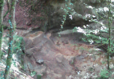
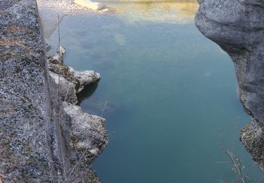
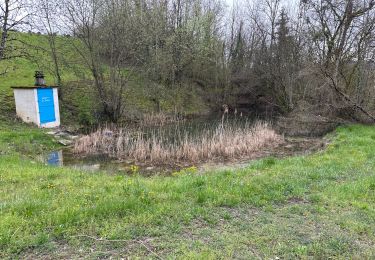
Cette balade familiale et champêtre, au départ de la place de l'église de Vieugy, permet de découvrir la biodiversité des marais de Lesse et Mathonex.Ces espaces naturels protégés abritent de nombreuses espèces d'animaux et surtout de remarquables insectes : papillons et libellules. Au fil des saisons vous pourrez contempler une grande variété de plantes : des orchidées, la jolie parnassie des marais, le populage des marais ou encore des trèfles d'eau. Actuellement c'est l'association Asters (Conservatoire des espaces naturels Haute Savoie) qui s'occupe de la préservation de ces zones humides. Idéal au printemps, en été ou en automne, ce chemin paisible est praticable aux randonneurs, aux VTTistes et aux cavaliers. Le point de départ de cette randonnée est accessible en transport en commun depuis le centre d'Annecy. Idéale pour des familles, le sentier alterne entre forêt, prairie et villages pittoresques !
Ort
Kommentare
Touren in der Umgebung
![Tour Wandern Chavanod - CHAVANOD - Photo](https://media.geolcdn.com/t/375/260/ext.jpg?maxdim=2&url=https%3A%2F%2Fservices.sitytrail.com%2FGeolivesWS%2FDownloadMedia.ashx%3FTrailID%3D642834%26Media%3Dcf99f68d-cd6d-4093-a6f9-aa7a1c09564a.png)
![Wandern Wandern](https://static1.geolcdn.com/sitytour/trail-icons/101.png)
Wandern
![](/images/other/stat-length.png)
![](https://static1.geolcdn.com/siteimages/upload/files/16400158638029165_repeat_loop_refresh_sync_direction_icon.png)
![Tour Wandern Lovagny - 28/02/2022 - Gorges du Fier - Nonglard - Lovagny - Chavanod - Photo](https://media.geolcdn.com/t/375/260/03500606-e21f-4d38-a3f6-549dc5117f26.jpg&format=jpg&maxdim=2)
![Wandern Wandern](https://static1.geolcdn.com/sitytour/trail-icons/101.png)
Wandern
![](/images/other/stat-length.png)
![](https://static1.geolcdn.com/siteimages/upload/files/16400158638029165_repeat_loop_refresh_sync_direction_icon.png)
![Tour Mountainbike Annecy - semnoz 31 8 10 - Photo](https://media.geolcdn.com/t/375/260/ext.jpg?maxdim=2&url=https%3A%2F%2Fstatic1.geolcdn.com%2Fsiteimages%2Fupload%2Ffiles%2F1524743154velo.jpg)
![Mountainbike Mountainbike](https://static1.geolcdn.com/sitytour/trail-icons/202.png)
Mountainbike
![](/images/other/stat-length.png)
![](https://static1.geolcdn.com/siteimages/upload/files/16400158638029165_repeat_loop_refresh_sync_direction_icon.png)
![Tour Wandern Chavanod - CHAVANOD ... vers Montagny-les-Lanches. - Photo](https://media.geolcdn.com/t/375/260/9cf02be8-0d43-4c97-a143-e34f6de46c37.jpg&format=jpg&maxdim=2)
![Wandern Wandern](https://static1.geolcdn.com/sitytour/trail-icons/101.png)
Wandern
![](/images/other/stat-length.png)
![](https://static1.geolcdn.com/siteimages/upload/files/16400158638029165_repeat_loop_refresh_sync_direction_icon.png)
![Tour Hybrid-Bike Annecy - ANNECY ... le Tour du lac à vélo. - Photo](https://media.geolcdn.com/t/375/260/64c38e9e-432d-4f1e-a098-d3a526529324.jpg&format=jpg&maxdim=2)
![Hybrid-Bike Hybrid-Bike](https://static1.geolcdn.com/sitytour/trail-icons/203.png)
Hybrid-Bike
![](/images/other/stat-length.png)
![](https://static1.geolcdn.com/siteimages/upload/files/16400158638029165_repeat_loop_refresh_sync_direction_icon.png)
![Tour Wandern Annecy - ANNECY ... le sentier des crêtes. - Photo](https://media.geolcdn.com/t/375/260/954e85ce-e790-4ec1-8a5b-52762288e410.jpg&format=jpg&maxdim=2)
![Wandern Wandern](https://static1.geolcdn.com/sitytour/trail-icons/101.png)
Wandern
![](/images/other/stat-length.png)
![](https://static1.geolcdn.com/siteimages/upload/files/16400158638029165_repeat_loop_refresh_sync_direction_icon.png)
![Tour Wandern Chavanod - CHAVANOD ... les Gorges du Fier. - Photo](https://media.geolcdn.com/t/375/260/b76880dc-3a6b-4b5d-9dee-7a400ed01ca2.jpg&format=jpg&maxdim=2)
![Wandern Wandern](https://static1.geolcdn.com/sitytour/trail-icons/101.png)
Wandern
![](/images/other/stat-length.png)
![](https://static1.geolcdn.com/siteimages/upload/files/16400158638029165_repeat_loop_refresh_sync_direction_icon.png)
![Tour sport Lovagny - 20230411 RANDONNÉE LOVAGNY - Photo](https://media.geolcdn.com/t/375/260/db936043-ccfb-4d87-a656-a3bf3f515ba1.jpg&format=jpg&maxdim=2)
sport
![](/images/other/stat-length.png)
![](https://static1.geolcdn.com/siteimages/upload/files/16400158638029165_repeat_loop_refresh_sync_direction_icon.png)
![Tour Wandern Annecy - A la découverte des Chalets de Barbenoire - Photo](https://media.geolcdn.com/t/375/260/d0978fe0-ad4b-4c05-8492-a52fbc7885e5.jpg&format=jpg&maxdim=2)
![Wandern Wandern](https://static1.geolcdn.com/sitytour/trail-icons/101.png)
Wandern
![](/images/other/stat-length.png)
![](https://static1.geolcdn.com/siteimages/upload/files/16400158638029165_repeat_loop_refresh_sync_direction_icon.png)