![](/images/other/stat-length.png)
![Tour Mountainbike Crévoux - Boucle du Réal - Photo](https://media.geolcdn.com/t/1900/400/ext.pjpeg?maxdim=2&url=https%3A%2F%2Fstatic1.geolcdn.com%2Fsiteimages%2Fupload%2Ffiles%2F1524743154velo.jpg)
Boucle du Réal
xaviergilles
Benutzer
![Länge](/images/other/stat-length.png)
Länge
13,5 km
![Maximale Höhe](https://static1.geolcdn.com/siteimages/upload/files/1508320355ic_sort_altitude_max_24dp.png)
Maximale Höhe
1915 m
![Positive Höhendifferenz](https://static1.geolcdn.com/siteimages/upload/files/1508320355ic_sort_den_pos_24dp.png)
Positive Höhendifferenz
419 m
![Km-Effort](/images/other/stat-length.png)
Km-Effort
19,2 km
![Min. Höhe](https://static1.geolcdn.com/siteimages/upload/files/1508320355ic_sort_altitude_min_24dp.png)
Min. Höhe
1593 m
![Negative Höhendifferenz](https://static1.geolcdn.com/siteimages/upload/files/1508320355ic_sort_den_neg_24dp.png)
Negative Höhendifferenz
457 m
![Boucle](https://static1.geolcdn.com/siteimages/upload/files/16400158638029165_repeat_loop_refresh_sync_direction_icon.png)
Boucle
Nein
Erstellungsdatum :
2021-08-13 13:07:12.0
Letzte Änderung :
2021-08-13 15:30:38.838
![Mountainbike](https://static1.geolcdn.com/sitytour/trail-icons/202.png)
2h00
Schwierigkeit : Einfach
![Scannen Sie diesen QR-Code, um die Tour in der SityTrail-Anwendung zu öffnen](https://capi.geolives.com/qq0zvz2zws4bq2lad0pu/sitytour/trails/2896773/qr.png?size=200)
Kostenlosegpshiking-Anwendung
Über SityTrail
Tour Mountainbike von 13,5 km verfügbar auf Provence-Alpes-Côte d'Azur, Hochalpen, Crévoux. Diese Tour wird von xaviergilles vorgeschlagen.
Beschreibung
Petite boucle dans mes bois de Crevoux. Très agréable, sans difficulté particulière. Quelques montées un petit peu pénibles de pour les plus petits mais courtes.
Ort
Land:
France
Region :
Provence-Alpes-Côte d'Azur
Abteilung/Provinz :
Hochalpen
Kommune :
Crévoux
Standort:
Unknown
Gehen Sie:(Dec)
Gehen Sie:(UTM)
311515 ; 4935148 (32T) N.
Kommentare
Touren in der Umgebung
![Tour Wandern Crévoux - La Cascade de Razis - Photo](https://media.geolcdn.com/t/375/260/ext.jpg?maxdim=2&url=https%3A%2F%2Fservices.sitytrail.com%2FGeolivesWS%2FDownloadMedia.ashx%3FTrailID%3D109634%26Media%3D4275_1.jpg)
![Wandern Wandern](https://static1.geolcdn.com/sitytour/trail-icons/101.png)
La Cascade de Razis
Wandern
Medium
(5)
Crévoux,
Provence-Alpes-Côte d'Azur,
Hochalpen,
France
![](/images/other/stat-length.png)
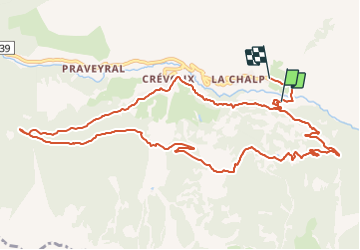
7,2 km | 11 km-effort
3h 30min
![](https://static1.geolcdn.com/siteimages/upload/files/16400158638029165_repeat_loop_refresh_sync_direction_icon.png)
Ja
![Tour Andere Aktivitäten Crévoux - Ski. Sommet de Meale par Praveyral - Photo](https://media.geolcdn.com/t/375/260/ext.jpg?maxdim=2&url=https%3A%2F%2Fstatic1.geolcdn.com%2Fsiteimages%2Fupload%2Ffiles%2F1545311037marcheuse_200dpi.jpg)
![Andere Aktivitäten Andere Aktivitäten](https://static1.geolcdn.com/sitytour/trail-icons/900.png)
Ski. Sommet de Meale par Praveyral
Andere Aktivitäten
Sehr leicht
(6)
Crévoux,
Provence-Alpes-Côte d'Azur,
Hochalpen,
France
![](/images/other/stat-length.png)
7,4 km | 16,7 km-effort
3h 20min
![](https://static1.geolcdn.com/siteimages/upload/files/16400158638029165_repeat_loop_refresh_sync_direction_icon.png)
Nein
![Tour Wandern Crévoux - boucle lac du crachet - Photo](https://media.geolcdn.com/t/375/260/ext.jpg?maxdim=2&url=https%3A%2F%2Fservices.sitytrail.com%2FGeolivesWS%2FDownloadMedia.ashx%3FTrailID%3D619371%26Media%3Dfix__20160821105233.jpg)
![Wandern Wandern](https://static1.geolcdn.com/sitytour/trail-icons/101.png)
boucle lac du crachet
Wandern
Schwierig
(1)
Crévoux,
Provence-Alpes-Côte d'Azur,
Hochalpen,
France
![](/images/other/stat-length.png)
10,3 km | 21 km-effort
4h 50min
![](https://static1.geolcdn.com/siteimages/upload/files/16400158638029165_repeat_loop_refresh_sync_direction_icon.png)
Ja
![Tour Wandern Crévoux - PARCOURS DES FEES #7 - Photo](https://media.geolcdn.com/t/375/260/ext.jpg?maxdim=2&url=https%3A%2F%2Fservices.sitytrail.com%2FGeolivesWS%2FDownloadMedia.ashx%3FTrailID%3D606320%26Media%3D812d22bb-a879-4b52-81d0-d1a210f7c536.JPG)
![Wandern Wandern](https://static1.geolcdn.com/sitytour/trail-icons/101.png)
PARCOURS DES FEES #7
Wandern
Medium
(1)
Crévoux,
Provence-Alpes-Côte d'Azur,
Hochalpen,
France
![](/images/other/stat-length.png)
8,3 km | 11,6 km-effort
2h 35min
![](https://static1.geolcdn.com/siteimages/upload/files/16400158638029165_repeat_loop_refresh_sync_direction_icon.png)
Ja
![Tour Wandern Les Orres - 2012-08-10_Sentier du garde - Photo](https://media.geolcdn.com/t/375/260/ext.jpg?maxdim=2&url=https%3A%2F%2Fservices.sitytrail.com%2FGeolivesWS%2FDownloadMedia.ashx%3FTrailID%3D145344%26Media%3D3eb37f19-c6a6-4c29-8161-da219dedd017.jpeg)
![Wandern Wandern](https://static1.geolcdn.com/sitytour/trail-icons/101.png)
2012-08-10_Sentier du garde
Wandern
Medium
(1)
Les Orres,
Provence-Alpes-Côte d'Azur,
Hochalpen,
France
![](/images/other/stat-length.png)
11,3 km | 17,6 km-effort
4h 6min
![](https://static1.geolcdn.com/siteimages/upload/files/16400158638029165_repeat_loop_refresh_sync_direction_icon.png)
Ja
![Tour Wandern Saint-André-d'Embrun - chalet de la biche . mont orel . chapelle de pra leydon . chalet de la coche - Photo](https://media.geolcdn.com/t/375/260/fc8a76ce-7e92-44f8-a3b6-e3a752334a37.jpg&format=jpg&maxdim=2)
![Wandern Wandern](https://static1.geolcdn.com/sitytour/trail-icons/101.png)
chalet de la biche . mont orel . chapelle de pra leydon . chalet de la coche
Wandern
Schwierig
Saint-André-d'Embrun,
Provence-Alpes-Côte d'Azur,
Hochalpen,
France
![](/images/other/stat-length.png)
9,4 km | 21 km-effort
4h 59min
![](https://static1.geolcdn.com/siteimages/upload/files/16400158638029165_repeat_loop_refresh_sync_direction_icon.png)
Nein
![Tour Wandern Crévoux - Sentier des Fées Crevoux 16/08/18 - Photo](https://media.geolcdn.com/t/375/260/62d5f5b8-1ebc-4b09-a28c-b9abebde2749.jpg&format=jpg&maxdim=2)
![Wandern Wandern](https://static1.geolcdn.com/sitytour/trail-icons/101.png)
Sentier des Fées Crevoux 16/08/18
Wandern
Einfach
Crévoux,
Provence-Alpes-Côte d'Azur,
Hochalpen,
France
![](/images/other/stat-length.png)
6,1 km | 9 km-effort
1h 52min
![](https://static1.geolcdn.com/siteimages/upload/files/16400158638029165_repeat_loop_refresh_sync_direction_icon.png)
Ja
![Tour Wandern Crévoux - Le lac du Crachet - Photo](https://media.geolcdn.com/t/375/260/ext.jpg?maxdim=2&url=https%3A%2F%2Fstatic1.geolcdn.com%2Fsiteimages%2Fupload%2Ffiles%2F1553511878bg_sport_marche.png)
![Wandern Wandern](https://static1.geolcdn.com/sitytour/trail-icons/101.png)
Le lac du Crachet
Wandern
Sehr leicht
(2)
Crévoux,
Provence-Alpes-Côte d'Azur,
Hochalpen,
France
![](/images/other/stat-length.png)
3,6 km | 9,7 km-effort
2h 15min
![](https://static1.geolcdn.com/siteimages/upload/files/16400158638029165_repeat_loop_refresh_sync_direction_icon.png)
Nein
![Tour Schneeschuhwandern Crévoux - EMBRUN JOUR 4 : Torrent du Crachet - Photo](https://media.geolcdn.com/t/375/260/3e9f82e9-86b1-4473-874d-37d7060460f8.jpg&format=jpg&maxdim=2)
![Schneeschuhwandern Schneeschuhwandern](https://static1.geolcdn.com/sitytour/trail-icons/504.png)
EMBRUN JOUR 4 : Torrent du Crachet
Schneeschuhwandern
Schwierig
Crévoux,
Provence-Alpes-Côte d'Azur,
Hochalpen,
France
![](/images/other/stat-length.png)
6,6 km | 12,8 km-effort
4h 13min
![](https://static1.geolcdn.com/siteimages/upload/files/16400158638029165_repeat_loop_refresh_sync_direction_icon.png)
Ja