![](/images/other/stat-length.png)
![Tour Mountainbike La Faurie - aureille - col montbrand - col st andré - Photo](https://media.geolcdn.com/t/1900/400/ext.pjpeg?maxdim=2&url=https%3A%2F%2Fstatic1.geolcdn.com%2Fsiteimages%2Fupload%2Ffiles%2F1524743154velo.jpg)
aureille - col montbrand - col st andré
jcpistono
Benutzer
![Länge](/images/other/stat-length.png)
Länge
23 km
![Maximale Höhe](https://static1.geolcdn.com/siteimages/upload/files/1508320355ic_sort_altitude_max_24dp.png)
Maximale Höhe
1459 m
![Positive Höhendifferenz](https://static1.geolcdn.com/siteimages/upload/files/1508320355ic_sort_den_pos_24dp.png)
Positive Höhendifferenz
920 m
![Km-Effort](/images/other/stat-length.png)
Km-Effort
35 km
![Min. Höhe](https://static1.geolcdn.com/siteimages/upload/files/1508320355ic_sort_altitude_min_24dp.png)
Min. Höhe
848 m
![Negative Höhendifferenz](https://static1.geolcdn.com/siteimages/upload/files/1508320355ic_sort_den_neg_24dp.png)
Negative Höhendifferenz
922 m
![Boucle](https://static1.geolcdn.com/siteimages/upload/files/16400158638029165_repeat_loop_refresh_sync_direction_icon.png)
Boucle
Ja
Erstellungsdatum :
2021-08-09 14:13:41.312
Letzte Änderung :
2021-08-09 17:05:07.58
![Mountainbike](https://static1.geolcdn.com/sitytour/trail-icons/202.png)
2h14
Schwierigkeit : Einfach
![Scannen Sie diesen QR-Code, um die Tour in der SityTrail-Anwendung zu öffnen](https://capi.geolives.com/qq0zvz2zws4bq2lad0pu/sitytour/trails/2891853/qr.png?size=200)
Kostenlosegpshiking-Anwendung
Über SityTrail
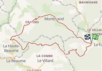
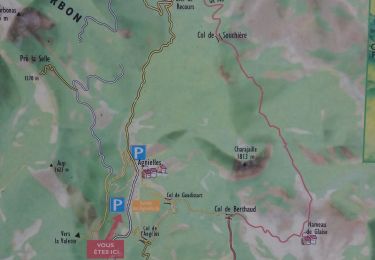
Tour Mountainbike von 23 km verfügbar auf Provence-Alpes-Côte d'Azur, Hochalpen, La Faurie. Diese Tour wird von jcpistono vorgeschlagen.
Beschreibung
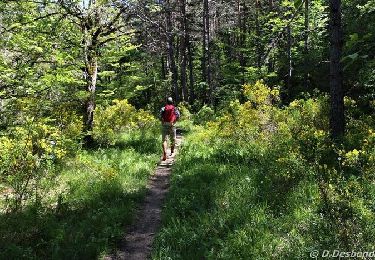
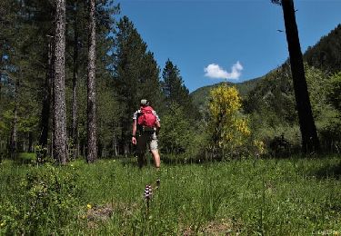
montee jusqu au col de la haite beaume sur route revetue - le reste sur chemin
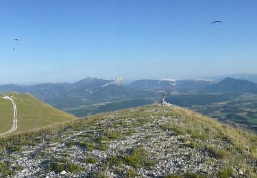
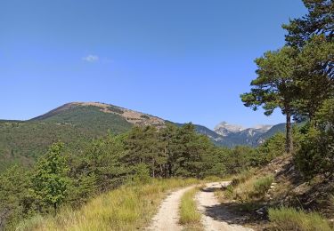
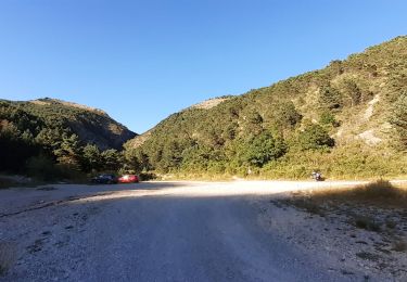
23km 920mdev - facile vttae - tres jolis panoramas - quelques descentes raides - montee courte mais tres pentue avant clos chouvin
Ort
Land:
France
Region :
Provence-Alpes-Côte d'Azur
Abteilung/Provinz :
Hochalpen
Kommune :
La Faurie
Standort:
Unknown
Gehen Sie:(Dec)
Gehen Sie:(UTM)
716597 ; 4938623 (31T) N.
Kommentare
Touren in der Umgebung
![Tour Wandern La Faurie - R40 Les Marmites du Diable - Photo](https://media.geolcdn.com/t/375/260/ext.jpg?maxdim=2&url=https%3A%2F%2Fservices.sitytrail.com%2FGeolivesWS%2FDownloadMedia.ashx%3FTrailID%3D890898%26Media%3D4cd300c4-1399-4070-a62f-7c6bb96deff3.jpg)
![Wandern Wandern](https://static1.geolcdn.com/sitytour/trail-icons/101.png)
R40 Les Marmites du Diable
Wandern
Medium
(6)
La Faurie,
Provence-Alpes-Côte d'Azur,
Hochalpen,
France
![](/images/other/stat-length.png)
5,9 km | 10,4 km-effort
2h 7min
![](https://static1.geolcdn.com/siteimages/upload/files/16400158638029165_repeat_loop_refresh_sync_direction_icon.png)
Ja
![Tour Wandern Aspres-sur-Buëch - R42 La Longeagne - Photo](https://media.geolcdn.com/t/375/260/b99af856-c65b-4514-8d24-55b47460362d.jpg&format=jpg&maxdim=2)
![Wandern Wandern](https://static1.geolcdn.com/sitytour/trail-icons/101.png)
R42 La Longeagne
Wandern
Sehr leicht
(1)
Aspres-sur-Buëch,
Provence-Alpes-Côte d'Azur,
Hochalpen,
France
![](/images/other/stat-length.png)
7,1 km | 11,2 km-effort
2h 23min
![](https://static1.geolcdn.com/siteimages/upload/files/16400158638029165_repeat_loop_refresh_sync_direction_icon.png)
Ja
![Tour Zu Fuß Montbrand - 9587037(1) - Photo](https://media.geolcdn.com/t/375/260/bd68d9f4-38b8-40ec-8fd6-e142fbd2e911.jpg&format=jpg&maxdim=2)
![Zu Fuß Zu Fuß](https://static1.geolcdn.com/sitytour/trail-icons/100.png)
9587037(1)
Zu Fuß
Einfach
Montbrand,
Provence-Alpes-Côte d'Azur,
Hochalpen,
France
![](/images/other/stat-length.png)
3,5 km | 4,6 km-effort
1h 2min
![](https://static1.geolcdn.com/siteimages/upload/files/16400158638029165_repeat_loop_refresh_sync_direction_icon.png)
Ja
![Tour Zu Fuß Aspres-sur-Buëch - 9587028 - Photo](https://media.geolcdn.com/t/375/260/b1cb76fb-8776-4159-b0ac-0bfcd9b6dede.jpg&format=jpg&maxdim=2)
![Zu Fuß Zu Fuß](https://static1.geolcdn.com/sitytour/trail-icons/100.png)
9587028
Zu Fuß
Einfach
Aspres-sur-Buëch,
Provence-Alpes-Côte d'Azur,
Hochalpen,
France
![](/images/other/stat-length.png)
3,4 km | 5,3 km-effort
1h 12min
![](https://static1.geolcdn.com/siteimages/upload/files/16400158638029165_repeat_loop_refresh_sync_direction_icon.png)
Ja
![Tour Mountainbike Aspres-sur-Buëch - Gorges de l'Agnielle - Photo](https://media.geolcdn.com/t/375/260/1229c874-0698-4459-bf02-ba8b4eeb2cd3.jpg&format=jpg&maxdim=2)
![Mountainbike Mountainbike](https://static1.geolcdn.com/sitytour/trail-icons/202.png)
Gorges de l'Agnielle
Mountainbike
Medium
Aspres-sur-Buëch,
Provence-Alpes-Côte d'Azur,
Hochalpen,
France
![](/images/other/stat-length.png)
12 km | 16,7 km-effort
2h 25min
![](https://static1.geolcdn.com/siteimages/upload/files/16400158638029165_repeat_loop_refresh_sync_direction_icon.png)
Ja
![Tour Mountainbike Saint-Pierre-d'Argençon - HA J3 long - Photo](https://media.geolcdn.com/t/375/260/ext.jpg?maxdim=2&url=https%3A%2F%2Fstatic1.geolcdn.com%2Fsiteimages%2Fupload%2Ffiles%2F1524743154velo.jpg)
![Mountainbike Mountainbike](https://static1.geolcdn.com/sitytour/trail-icons/202.png)
HA J3 long
Mountainbike
Sehr leicht
(4)
Saint-Pierre-d'Argençon,
Provence-Alpes-Côte d'Azur,
Hochalpen,
France
![](/images/other/stat-length.png)
34 km | 42 km-effort
2h 45min
![](https://static1.geolcdn.com/siteimages/upload/files/16400158638029165_repeat_loop_refresh_sync_direction_icon.png)
Nein
![Tour Wandern La Faurie - les marmites du Diable - Photo](https://media.geolcdn.com/t/375/260/f38e50fc-2b4c-4715-ab2e-7dfb77ad5a44.jpg&format=jpg&maxdim=2)
![Wandern Wandern](https://static1.geolcdn.com/sitytour/trail-icons/101.png)
les marmites du Diable
Wandern
Schwierig
La Faurie,
Provence-Alpes-Côte d'Azur,
Hochalpen,
France
![](/images/other/stat-length.png)
6,1 km | 10,4 km-effort
2h 59min
![](https://static1.geolcdn.com/siteimages/upload/files/16400158638029165_repeat_loop_refresh_sync_direction_icon.png)
Ja
![Tour Wandern Montbrand - montbrand - Photo](https://media.geolcdn.com/t/375/260/3e70d8ad-eab1-47bc-8ebe-533087057d8e.jpg&format=jpg&maxdim=2)
![Wandern Wandern](https://static1.geolcdn.com/sitytour/trail-icons/101.png)
montbrand
Wandern
Einfach
Montbrand,
Provence-Alpes-Côte d'Azur,
Hochalpen,
France
![](/images/other/stat-length.png)
3,8 km | 5,1 km-effort
1h 3min
![](https://static1.geolcdn.com/siteimages/upload/files/16400158638029165_repeat_loop_refresh_sync_direction_icon.png)
Ja
![Tour Wandern La Faurie - SityTrail - SityTrail - La Vallette - Agnielles - Marmites du Diable - Photo](https://media.geolcdn.com/t/375/260/dae49d57-d0a2-4d2e-8096-1ca7f21776f8.jpg&format=jpg&maxdim=2)
![Wandern Wandern](https://static1.geolcdn.com/sitytour/trail-icons/101.png)
SityTrail - SityTrail - La Vallette - Agnielles - Marmites du Diable
Wandern
Sehr schwierig
La Faurie,
Provence-Alpes-Côte d'Azur,
Hochalpen,
France
![](/images/other/stat-length.png)
15,6 km | 28 km-effort
6h 15min
![](https://static1.geolcdn.com/siteimages/upload/files/16400158638029165_repeat_loop_refresh_sync_direction_icon.png)
Ja