![](/images/other/stat-length.png)
![Tour Wandern La Salle-les-Alpes - 2021-08-07_08h55m47_la-cime-de-puy-la-salle - Photo](https://media.geolcdn.com/t/1900/400/ext.pjpeg?maxdim=2&url=https%3A%2F%2Fstatic1.geolcdn.com%2Fsiteimages%2Fupload%2Ffiles%2F1553511878bg_sport_marche.png)
2021-08-07_08h55m47_la-cime-de-puy-la-salle
jpb83
Benutzer
![Länge](/images/other/stat-length.png)
![Maximale Höhe](https://static1.geolcdn.com/siteimages/upload/files/1508320355ic_sort_altitude_max_24dp.png)
![Positive Höhendifferenz](https://static1.geolcdn.com/siteimages/upload/files/1508320355ic_sort_den_pos_24dp.png)
![Km-Effort](/images/other/stat-length.png)
![Min. Höhe](https://static1.geolcdn.com/siteimages/upload/files/1508320355ic_sort_altitude_min_24dp.png)
![Negative Höhendifferenz](https://static1.geolcdn.com/siteimages/upload/files/1508320355ic_sort_den_neg_24dp.png)
![Boucle](https://static1.geolcdn.com/siteimages/upload/files/16400158638029165_repeat_loop_refresh_sync_direction_icon.png)
![Wandern](https://static1.geolcdn.com/sitytour/trail-icons/101.png)
3h12
Schwierigkeit : Schwierig
![Scannen Sie diesen QR-Code, um die Tour in der SityTrail-Anwendung zu öffnen](https://capi.geolives.com/qq0zvz2zws4bq2lad0pu/sitytour/trails/2888265/qr.png?size=200)
Kostenlosegpshiking-Anwendung
Über SityTrail
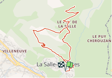
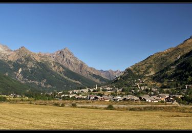
Tour Wandern von 7 km verfügbar auf Provence-Alpes-Côte d'Azur, Hochalpen, La Salle-les-Alpes. Diese Tour wird von jpb83 vorgeschlagen.
Beschreibung
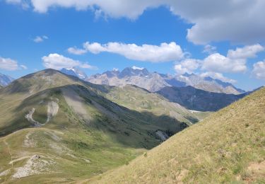
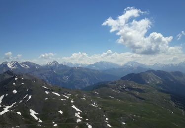
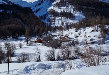
Promenade courte à proximité de Villeneuve, beau point de vue sur le massif et le domaine d'altitude.
Sur le versant sud, cette promenade chemine progressivement le long du Torrent de la Salle.
Départ / Arrivée : Entrée du village de la Salle - Coté Sud
Emprunter le chemin carrossable qui s'élève juste avant le pont, à l'entrée sud du village de La Salle.
Monter en direction des maisons de "Rivo".
1- Après avoir traverser le torrent continuer avant de bifurquer à droite en direction des Tures.
Aux chalets des Thures tenir le sentier à droite et continuer la progression jusqu'aux chalets d'alpage de Puy la Salle (1880 m).
Gagner ensuite la Cime de Puy la Salle, 100 mètres plus haut (1980 m).
2 - Pour le retour, emprunter le sentier qui redescend vers "le Piré" puis revenir par une autre route de terre qui revient au village de la Salle.
Ort
Kommentare
Touren in der Umgebung
![Tour Wandern Saint-Chaffrey - le Prorel au départ de la Serre Chevalier - Photo](https://media.geolcdn.com/t/375/260/8fe43045-679c-4525-8bd4-b81d7f3d7490.jpg&format=jpg&maxdim=2)
![Wandern Wandern](https://static1.geolcdn.com/sitytour/trail-icons/101.png)
Wandern
![](/images/other/stat-length.png)
![](https://static1.geolcdn.com/siteimages/upload/files/16400158638029165_repeat_loop_refresh_sync_direction_icon.png)
![Tour Wandern La Salle-les-Alpes - le grand Aréa (boucle) - Photo](https://media.geolcdn.com/t/375/260/2c5e44d9-ecb7-452d-bd8a-94765088c19f.jpg&format=jpg&maxdim=2)
![Wandern Wandern](https://static1.geolcdn.com/sitytour/trail-icons/101.png)
Wandern
![](/images/other/stat-length.png)
![](https://static1.geolcdn.com/siteimages/upload/files/16400158638029165_repeat_loop_refresh_sync_direction_icon.png)
![Tour Wandern La Salle-les-Alpes - Grand AREA 21/06/18 - Photo](https://media.geolcdn.com/t/375/260/86fd0548-34c0-4cb0-a2ba-6eed03b231af.jpg&format=jpg&maxdim=2)
![Wandern Wandern](https://static1.geolcdn.com/sitytour/trail-icons/101.png)
Wandern
![](/images/other/stat-length.png)
![](https://static1.geolcdn.com/siteimages/upload/files/16400158638029165_repeat_loop_refresh_sync_direction_icon.png)
![Tour Wandern Saint-Chaffrey - Chantemerle-la Salle les Aples 13-08-2018 - Photo](https://media.geolcdn.com/t/375/260/ext.jpg?maxdim=2&url=https%3A%2F%2Fstatic1.geolcdn.com%2Fsiteimages%2Fupload%2Ffiles%2F1553511878bg_sport_marche.png)
![Wandern Wandern](https://static1.geolcdn.com/sitytour/trail-icons/101.png)
Wandern
![](/images/other/stat-length.png)
![](https://static1.geolcdn.com/siteimages/upload/files/16400158638029165_repeat_loop_refresh_sync_direction_icon.png)
![Tour Mountainbike Saint-Chaffrey - granons tronchet - Photo](https://media.geolcdn.com/t/375/260/ext.jpg?maxdim=2&url=https%3A%2F%2Fstatic1.geolcdn.com%2Fsiteimages%2Fupload%2Ffiles%2F1524743154velo.jpg)
![Mountainbike Mountainbike](https://static1.geolcdn.com/sitytour/trail-icons/202.png)
Mountainbike
![](/images/other/stat-length.png)
![](https://static1.geolcdn.com/siteimages/upload/files/16400158638029165_repeat_loop_refresh_sync_direction_icon.png)
![Tour Wandern Saint-Chaffrey - 05 lacs de l'oule,christol,rond 25/08/24 - Photo](https://media.geolcdn.com/t/375/260/8fa64624-96b2-461e-80f5-25df14bfce59.jpg&format=jpg&maxdim=2)
![Wandern Wandern](https://static1.geolcdn.com/sitytour/trail-icons/101.png)
Wandern
![](/images/other/stat-length.png)
![](https://static1.geolcdn.com/siteimages/upload/files/16400158638029165_repeat_loop_refresh_sync_direction_icon.png)
![Tour Wandern Le Monêtier-les-Bains - Les Boussardes - Photo](https://media.geolcdn.com/t/375/260/404ff157-d268-4b88-bced-a12b6573121a.jpg&format=jpg&maxdim=2)
![Wandern Wandern](https://static1.geolcdn.com/sitytour/trail-icons/101.png)
Wandern
![](/images/other/stat-length.png)
![](https://static1.geolcdn.com/siteimages/upload/files/16400158638029165_repeat_loop_refresh_sync_direction_icon.png)
![Tour Wandern Saint-Chaffrey - col du granon-croix de la cime - Photo](https://media.geolcdn.com/t/375/260/7bf366d1-6261-4976-a3ad-d0b07d26ff8c.jpg&format=jpg&maxdim=2)
![Wandern Wandern](https://static1.geolcdn.com/sitytour/trail-icons/101.png)
Wandern
![](/images/other/stat-length.png)
![](https://static1.geolcdn.com/siteimages/upload/files/16400158638029165_repeat_loop_refresh_sync_direction_icon.png)
![Tour Wandern Le Monêtier-les-Bains - Grand Aréa - Photo](https://media.geolcdn.com/t/375/260/183c96a2-203b-45f5-bf34-18c8407695c1.jpg&format=jpg&maxdim=2)
![Wandern Wandern](https://static1.geolcdn.com/sitytour/trail-icons/101.png)
Wandern
![](/images/other/stat-length.png)
![](https://static1.geolcdn.com/siteimages/upload/files/16400158638029165_repeat_loop_refresh_sync_direction_icon.png)