![](/images/other/stat-length.png)
![Tour Rennrad Quelmes - Quelmes/Boulogne-sur-Mer/Quelmes 102Kms (Dén P 1423m) - Photo](https://media.geolcdn.com/t/1900/400/ext.pjpeg?maxdim=2&url=https%3A%2F%2Fstatic1.geolcdn.com%2Fsiteimages%2Fupload%2Ffiles%2F1524743154velo.jpg)
Quelmes/Boulogne-sur-Mer/Quelmes 102Kms (Dén P 1423m)
alain62rando
Benutzer
![Länge](/images/other/stat-length.png)
Länge
102 km
![Maximale Höhe](https://static1.geolcdn.com/siteimages/upload/files/1508320355ic_sort_altitude_max_24dp.png)
Maximale Höhe
209 m
![Positive Höhendifferenz](https://static1.geolcdn.com/siteimages/upload/files/1508320355ic_sort_den_pos_24dp.png)
Positive Höhendifferenz
1423 m
![Km-Effort](/images/other/stat-length.png)
Km-Effort
121 km
![Min. Höhe](https://static1.geolcdn.com/siteimages/upload/files/1508320355ic_sort_altitude_min_24dp.png)
Min. Höhe
4 m
![Negative Höhendifferenz](https://static1.geolcdn.com/siteimages/upload/files/1508320355ic_sort_den_neg_24dp.png)
Negative Höhendifferenz
1424 m
![Boucle](https://static1.geolcdn.com/siteimages/upload/files/16400158638029165_repeat_loop_refresh_sync_direction_icon.png)
Boucle
Ja
Erstellungsdatum :
2021-08-05 16:55:34.988
Letzte Änderung :
2021-08-08 17:17:58.502
![Rennrad](https://static1.geolcdn.com/sitytour/trail-icons/201.png)
3h50
Schwierigkeit : Medium
![Scannen Sie diesen QR-Code, um die Tour in der SityTrail-Anwendung zu öffnen](https://capi.geolives.com/qq0zvz2zws4bq2lad0pu/sitytour/trails/2886637/qr.png?size=200)
Kostenlosegpshiking-Anwendung
Über SityTrail
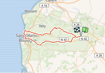
Tour Rennrad von 102 km verfügbar auf Nordfrankreich, Pas-de-Calais, Quelmes. Diese Tour wird von alain62rando vorgeschlagen.
Beschreibung
Belle randonnée avec les superbes paysages du Boulonnais.
La montée du mont Lambert puis la porte Gayolle.
La vallée du Wimereux, la montée dans la forêt de Colembert.
Que du bonheur..
Ort
Land:
France
Region :
Nordfrankreich
Abteilung/Provinz :
Pas-de-Calais
Kommune :
Quelmes
Standort:
Unknown
Gehen Sie:(Dec)
Gehen Sie:(UTM)
439346 ; 5620818 (31U) N.
Kommentare
Touren in der Umgebung
![Tour Wandern Tilques - Des Cressonnières au Marais - Tilques - Photo](https://media.geolcdn.com/t/375/260/ext.jpg?maxdim=2&url=https%3A%2F%2Fservices.sitytrail.com%2FGeolivesWS%2FDownloadMedia.ashx%3FTrailID%3D105199%26Media%3D8836_2.jpg)
![Wandern Wandern](https://static1.geolcdn.com/sitytour/trail-icons/101.png)
Des Cressonnières au Marais - Tilques
Wandern
Medium
(1)
Tilques,
Nordfrankreich,
Pas-de-Calais,
France
![](/images/other/stat-length.png)
10,7 km | 11,4 km-effort
2h 30min
![](https://static1.geolcdn.com/siteimages/upload/files/16400158638029165_repeat_loop_refresh_sync_direction_icon.png)
Ja
![Tour Wandern Moringhem - Moringhem - Photo](https://media.geolcdn.com/t/375/260/ext.jpg?maxdim=2&url=https%3A%2F%2Fmedia.geolcdn.com%2Ff%2F19ec6069-bead-4ae6-ab83-c67ef270996d.jpeg)
![Wandern Wandern](https://static1.geolcdn.com/sitytour/trail-icons/101.png)
Moringhem
Wandern
Schwierig
(1)
Moringhem,
Nordfrankreich,
Pas-de-Calais,
France
![](/images/other/stat-length.png)
11 km | 13,5 km-effort
2h 12min
![](https://static1.geolcdn.com/siteimages/upload/files/16400158638029165_repeat_loop_refresh_sync_direction_icon.png)
Ja
![Tour Mountainbike Lumbres - Les Grands Camps - Lumbres - Photo](https://media.geolcdn.com/t/375/260/ext.jpg?maxdim=2&url=https%3A%2F%2Fservices.sitytrail.com%2FGeolivesWS%2FDownloadMedia.ashx%3FTrailID%3D112093%26Media%3D9873_6.jpg)
![Mountainbike Mountainbike](https://static1.geolcdn.com/sitytour/trail-icons/202.png)
Les Grands Camps - Lumbres
Mountainbike
Schwierig
Lumbres,
Nordfrankreich,
Pas-de-Calais,
France
![](/images/other/stat-length.png)
24 km | 30 km-effort
3h 0min
![](https://static1.geolcdn.com/siteimages/upload/files/16400158638029165_repeat_loop_refresh_sync_direction_icon.png)
Ja
![Tour Wandern Zudausques - Les Cormettes - Zudausques - Photo](https://media.geolcdn.com/t/375/260/ext.jpg?maxdim=2&url=https%3A%2F%2Fservices.sitytrail.com%2FGeolivesWS%2FDownloadMedia.ashx%3FTrailID%3D112080%26Media%3D9729_5.jpg)
![Wandern Wandern](https://static1.geolcdn.com/sitytour/trail-icons/101.png)
Les Cormettes - Zudausques
Wandern
Einfach
(1)
Zudausques,
Nordfrankreich,
Pas-de-Calais,
France
![](/images/other/stat-length.png)
6,5 km | 7,7 km-effort
1h 40min
![](https://static1.geolcdn.com/siteimages/upload/files/16400158638029165_repeat_loop_refresh_sync_direction_icon.png)
Ja
![Tour Wandern Esquerdes - esquerdes - Photo](https://media.geolcdn.com/t/375/260/ext.jpg?maxdim=2&url=https%3A%2F%2Fmedia.geolcdn.com%2Ff%2Ff5006276-f835-4c04-a8c6-f46372f2fc0d.jpg)
![Wandern Wandern](https://static1.geolcdn.com/sitytour/trail-icons/101.png)
esquerdes
Wandern
Schwierig
Esquerdes,
Nordfrankreich,
Pas-de-Calais,
France
![](/images/other/stat-length.png)
12,1 km | 15,4 km-effort
2h 38min
![](https://static1.geolcdn.com/siteimages/upload/files/16400158638029165_repeat_loop_refresh_sync_direction_icon.png)
Nein
![Tour Mountainbike Acquin-Westbécourt - 2011-10-16 - 11h33m49 - Photo](https://media.geolcdn.com/t/375/260/ext.jpg?maxdim=2&url=https%3A%2F%2Fservices.sitytrail.com%2FGeolivesWS%2FDownloadMedia.ashx%3FTrailID%3D86860%26Media%3D20111016111641.jpg)
![Mountainbike Mountainbike](https://static1.geolcdn.com/sitytour/trail-icons/202.png)
2011-10-16 - 11h33m49
Mountainbike
Sehr leicht
Acquin-Westbécourt,
Nordfrankreich,
Pas-de-Calais,
France
![](/images/other/stat-length.png)
22 km | 26 km-effort
2h 15min
![](https://static1.geolcdn.com/siteimages/upload/files/16400158638029165_repeat_loop_refresh_sync_direction_icon.png)
Ja
![Tour Wandern Hallines - Le ravin de Pihen 9.8km et 120m déniv - Photo](https://media.geolcdn.com/t/375/260/ext.jpg?maxdim=2&url=https%3A%2F%2Fstatic1.geolcdn.com%2Fsiteimages%2Fupload%2Ffiles%2F1553511878bg_sport_marche.png)
![Wandern Wandern](https://static1.geolcdn.com/sitytour/trail-icons/101.png)
Le ravin de Pihen 9.8km et 120m déniv
Wandern
Medium
Hallines,
Nordfrankreich,
Pas-de-Calais,
France
![](/images/other/stat-length.png)
9,8 km | 11,4 km-effort
2h 35min
![](https://static1.geolcdn.com/siteimages/upload/files/16400158638029165_repeat_loop_refresh_sync_direction_icon.png)
Ja
![Tour Wandern Tilques - Au Coeur du marais - Photo](https://media.geolcdn.com/t/375/260/ext.jpg?maxdim=2&url=https%3A%2F%2Fstatic1.geolcdn.com%2Fsiteimages%2Fupload%2Ffiles%2F1553511878bg_sport_marche.png)
![Wandern Wandern](https://static1.geolcdn.com/sitytour/trail-icons/101.png)
Au Coeur du marais
Wandern
Einfach
Tilques,
Nordfrankreich,
Pas-de-Calais,
France
![](/images/other/stat-length.png)
8,3 km | 8,8 km-effort
2h 5min
![](https://static1.geolcdn.com/siteimages/upload/files/16400158638029165_repeat_loop_refresh_sync_direction_icon.png)
Ja
![Tour Wandern Esquerdes - Dans les méandres d'un fleuve côtier - Photo](https://media.geolcdn.com/t/375/260/ext.jpg?maxdim=2&url=https%3A%2F%2Fstatic1.geolcdn.com%2Fsiteimages%2Fupload%2Ffiles%2F1553511878bg_sport_marche.png)
![Wandern Wandern](https://static1.geolcdn.com/sitytour/trail-icons/101.png)
Dans les méandres d'un fleuve côtier
Wandern
Medium
Esquerdes,
Nordfrankreich,
Pas-de-Calais,
France
![](/images/other/stat-length.png)
13,2 km | 16,7 km-effort
3h 30min
![](https://static1.geolcdn.com/siteimages/upload/files/16400158638029165_repeat_loop_refresh_sync_direction_icon.png)
Ja