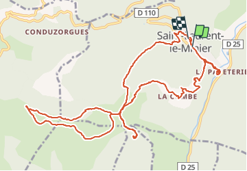
![](/images/other/stat-length.png)
![Tour Wandern Saint-Laurent-le-Minier - St Laurent le Minier - cascade au village et grotte de l'Enjeau - Photo](https://media.geolcdn.com/t/1900/400/19a97a1d-c5d1-47a1-a832-d3d7672cf8b2.jpg&format=pjpeg&maxdim=2)
St Laurent le Minier - cascade au village et grotte de l'Enjeau
Bart2015
Benutzer
![Länge](/images/other/stat-length.png)
![Maximale Höhe](https://static1.geolcdn.com/siteimages/upload/files/1508320355ic_sort_altitude_max_24dp.png)
![Positive Höhendifferenz](https://static1.geolcdn.com/siteimages/upload/files/1508320355ic_sort_den_pos_24dp.png)
![Km-Effort](/images/other/stat-length.png)
![Min. Höhe](https://static1.geolcdn.com/siteimages/upload/files/1508320355ic_sort_altitude_min_24dp.png)
![Negative Höhendifferenz](https://static1.geolcdn.com/siteimages/upload/files/1508320355ic_sort_den_neg_24dp.png)
![Boucle](https://static1.geolcdn.com/siteimages/upload/files/16400158638029165_repeat_loop_refresh_sync_direction_icon.png)
![Wandern](https://static1.geolcdn.com/sitytour/trail-icons/101.png)
5h23
Schwierigkeit : Medium
![Scannen Sie diesen QR-Code, um die Tour in der SityTrail-Anwendung zu öffnen](https://capi.geolives.com/qq0zvz2zws4bq2lad0pu/sitytour/trails/2886294/qr.png?size=200)
Kostenlosegpshiking-Anwendung
Über SityTrail
Tour Wandern von 15,4 km verfügbar auf Okzitanien, Gard, Saint-Laurent-le-Minier. Diese Tour wird von Bart2015 vorgeschlagen.
Beschreibung
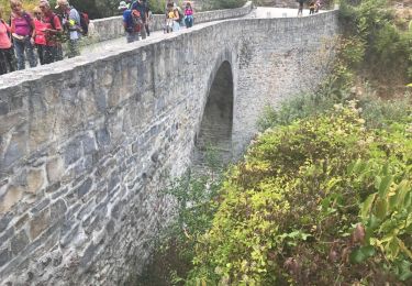
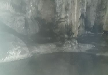
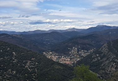
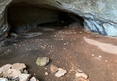
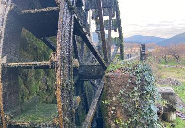
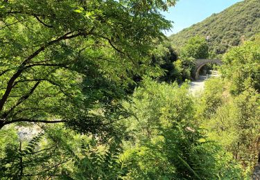
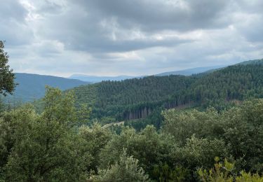
Belle randonnée au départ du joli village de St Laurent. Vous serez peut-être surpris de devoir payer un parking (8 €) mais vous comprendrez au retour, si vous partez de bonne heure le matin. Commencez la balade en allant voir la cascade et le château à l'entrée du village, vous ne le regretterez pas, la cascade est magnifique. La deuxième curiosité de la balade, c'est la grotte d'Enjeau. N'oubliez pas la lampe frontale car vous en aurez besoin. Ce que vous découvrirez est magnifique, un vrai trésor, à respecter comme il se doit ...
Vous pourrez d'ailleurs raccourcir la balade en ne faisant pas la boucle du Pic d'Enjeau qui présente peu d'intérêt. Au retour, le magnifique hameau de La Combe mérite de s'y arrêter.
De retour à St Laurent, peut-être une envie de se baigner, mais pas sûr ...
Bonne randonnée ...
Ort
Kommentare
Touren in der Umgebung
![Tour Wandern Ganges - les Mines de Ganges - Photo](https://media.geolcdn.com/t/375/260/ext.jpg?maxdim=2&url=https%3A%2F%2Fservices.sitytrail.com%2FGeolivesWS%2FDownloadMedia.ashx%3FTrailID%3D835756%26Media%3D20170926145921.jpg)
![Wandern Wandern](https://static1.geolcdn.com/sitytour/trail-icons/101.png)
Wandern
![](/images/other/stat-length.png)
![](https://static1.geolcdn.com/siteimages/upload/files/16400158638029165_repeat_loop_refresh_sync_direction_icon.png)
![Tour Wandern Saint-Laurent-le-Minier - pic et grotte d Anneau au depart de St Laurent le Minier - Photo](https://media.geolcdn.com/t/375/260/f8302bfe-8e81-4700-a65e-4420a9b2464f.jpg&format=jpg&maxdim=2)
![Wandern Wandern](https://static1.geolcdn.com/sitytour/trail-icons/101.png)
Wandern
![](/images/other/stat-length.png)
![](https://static1.geolcdn.com/siteimages/upload/files/16400158638029165_repeat_loop_refresh_sync_direction_icon.png)
![Tour Wandern Saint-Laurent-le-Minier - Saint-Laurent-du-Minier - grotte d'Anjeau - tour du pic d'Anjeau - cascade de la Vis - Photo](https://media.geolcdn.com/t/375/260/ext.jpg?maxdim=2&url=https%3A%2F%2Fstatic1.geolcdn.com%2Fsiteimages%2Fupload%2Ffiles%2F1553511878bg_sport_marche.png)
![Wandern Wandern](https://static1.geolcdn.com/sitytour/trail-icons/101.png)
Wandern
![](/images/other/stat-length.png)
![](https://static1.geolcdn.com/siteimages/upload/files/16400158638029165_repeat_loop_refresh_sync_direction_icon.png)
![Tour Wandern Ganges - Ganges Mont Méjean Patus - Photo](https://media.geolcdn.com/t/375/260/d13dbb51-1efc-45d9-b2a4-80c894df3817.jpg&format=jpg&maxdim=2)
![Wandern Wandern](https://static1.geolcdn.com/sitytour/trail-icons/101.png)
Wandern
![](/images/other/stat-length.png)
![](https://static1.geolcdn.com/siteimages/upload/files/16400158638029165_repeat_loop_refresh_sync_direction_icon.png)
![Tour Wandern Ganges - Ganges - Photo](https://media.geolcdn.com/t/375/260/4575900d-b3d8-4c13-902c-aa02010ad0fe.jpg&format=jpg&maxdim=2)
![Wandern Wandern](https://static1.geolcdn.com/sitytour/trail-icons/101.png)
![Tour Wandern Ganges - Ganges bois de Montmale Laroque - Photo](https://media.geolcdn.com/t/375/260/bd719afb-95dd-4c59-b658-066c5b6f640e.jpg&format=jpg&maxdim=2)
![Wandern Wandern](https://static1.geolcdn.com/sitytour/trail-icons/101.png)
Wandern
![](/images/other/stat-length.png)
![](https://static1.geolcdn.com/siteimages/upload/files/16400158638029165_repeat_loop_refresh_sync_direction_icon.png)
![Tour Wandern Ganges - De Ganges à Laroque par le bois de Montmal - Photo](https://media.geolcdn.com/t/375/260/bc75e769-e703-48b5-8e7d-3d36e985717b.jpg&format=jpg&maxdim=2)
![Wandern Wandern](https://static1.geolcdn.com/sitytour/trail-icons/101.png)
Wandern
![](/images/other/stat-length.png)
![](https://static1.geolcdn.com/siteimages/upload/files/16400158638029165_repeat_loop_refresh_sync_direction_icon.png)
![Tour Wandern Ganges - Ranc de Banes-Ganges-13-06-22 - Photo](https://media.geolcdn.com/t/375/260/f7c9d32f-3b57-45dd-8e16-6949fe33b659.jpg&format=jpg&maxdim=2)
![Wandern Wandern](https://static1.geolcdn.com/sitytour/trail-icons/101.png)
Wandern
![](/images/other/stat-length.png)
![](https://static1.geolcdn.com/siteimages/upload/files/16400158638029165_repeat_loop_refresh_sync_direction_icon.png)
![Tour Wandern Saint-Bresson - Saint Bresson - Photo](https://media.geolcdn.com/t/375/260/15d7e237-e2dc-49a4-a22d-b2a753ce536e.jpg&format=jpg&maxdim=2)
![Wandern Wandern](https://static1.geolcdn.com/sitytour/trail-icons/101.png)
Wandern
![](/images/other/stat-length.png)
![](https://static1.geolcdn.com/siteimages/upload/files/16400158638029165_repeat_loop_refresh_sync_direction_icon.png)