![](/images/other/stat-length.png)
![Tour Wandern Lormes - lormes 7.2 km - Photo](https://media.geolcdn.com/t/1900/400/216a1554-4850-4ff9-bd73-9c768387e73d.jpg&format=pjpeg&maxdim=2)
lormes 7.2 km
famillerudent
Benutzer
![Länge](/images/other/stat-length.png)
Länge
7,2 km
![Maximale Höhe](https://static1.geolcdn.com/siteimages/upload/files/1508320355ic_sort_altitude_max_24dp.png)
Maximale Höhe
453 m
![Positive Höhendifferenz](https://static1.geolcdn.com/siteimages/upload/files/1508320355ic_sort_den_pos_24dp.png)
Positive Höhendifferenz
173 m
![Km-Effort](/images/other/stat-length.png)
Km-Effort
9,5 km
![Min. Höhe](https://static1.geolcdn.com/siteimages/upload/files/1508320355ic_sort_altitude_min_24dp.png)
Min. Höhe
310 m
![Negative Höhendifferenz](https://static1.geolcdn.com/siteimages/upload/files/1508320355ic_sort_den_neg_24dp.png)
Negative Höhendifferenz
172 m
![Boucle](https://static1.geolcdn.com/siteimages/upload/files/16400158638029165_repeat_loop_refresh_sync_direction_icon.png)
Boucle
Ja
Erstellungsdatum :
2021-08-02 10:46:37.795
Letzte Änderung :
2021-08-05 11:16:14.68
![Wandern](https://static1.geolcdn.com/sitytour/trail-icons/101.png)
2h08
Schwierigkeit : Einfach
![Scannen Sie diesen QR-Code, um die Tour in der SityTrail-Anwendung zu öffnen](https://capi.geolives.com/qq0zvz2zws4bq2lad0pu/sitytour/trails/2882951/qr.png?size=200)
Kostenlosegpshiking-Anwendung
Über SityTrail
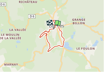
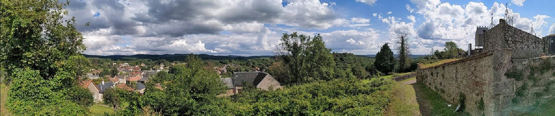
Tour Wandern von 7,2 km verfügbar auf Burgund und Freigrafschaft, Nièvre, Lormes. Diese Tour wird von famillerudent vorgeschlagen.
Beschreibung
petite boucle trés sympathique au depart de lormes puis traversée des gorges de narvau (coin trés agréable avec 2 ou 3 tables de picnique)
arret possible au bord de l'étang de goulot ou une petite buvette vous attend.
bonne randonnée
Ort
Land:
France
Region :
Burgund und Freigrafschaft
Abteilung/Provinz :
Nièvre
Kommune :
Lormes
Standort:
Unknown
Gehen Sie:(Dec)
Gehen Sie:(UTM)
561755 ; 5237438 (31T) N.
Kommentare
Touren in der Umgebung
![Tour Wandern Magny-Lormes - De Magny les Lormes à Usy - Photo](https://media.geolcdn.com/t/375/260/ext.jpg?maxdim=2&url=https%3A%2F%2Fstatic1.geolcdn.com%2Fsiteimages%2Fupload%2Ffiles%2F1553511878bg_sport_marche.png)
![Wandern Wandern](https://static1.geolcdn.com/sitytour/trail-icons/101.png)
De Magny les Lormes à Usy
Wandern
Sehr schwierig
Magny-Lormes,
Burgund und Freigrafschaft,
Nièvre,
France
![](/images/other/stat-length.png)
20 km | 27 km-effort
6h 5min
![](https://static1.geolcdn.com/siteimages/upload/files/16400158638029165_repeat_loop_refresh_sync_direction_icon.png)
Nein
![Tour Wandern Pouques-Lormes - Pouques-Lormes - Photo](https://media.geolcdn.com/t/375/260/ext.jpg?maxdim=2&url=https%3A%2F%2Fstatic1.geolcdn.com%2Fsiteimages%2Fupload%2Ffiles%2F1553511878bg_sport_marche.png)
![Wandern Wandern](https://static1.geolcdn.com/sitytour/trail-icons/101.png)
Pouques-Lormes
Wandern
Sehr leicht
Pouques-Lormes,
Burgund und Freigrafschaft,
Nièvre,
France
![](/images/other/stat-length.png)
7,1 km | 9,1 km-effort
2h 17min
![](https://static1.geolcdn.com/siteimages/upload/files/16400158638029165_repeat_loop_refresh_sync_direction_icon.png)
Ja
![Tour Wandern Lormes - Frankrijk - De omgeving van Lormes - Photo](https://media.geolcdn.com/t/375/260/ext.jpg?maxdim=2&url=https%3A%2F%2Fstatic1.geolcdn.com%2Fsiteimages%2Fupload%2Ffiles%2F1553511878bg_sport_marche.png)
![Wandern Wandern](https://static1.geolcdn.com/sitytour/trail-icons/101.png)
Frankrijk - De omgeving van Lormes
Wandern
Sehr leicht
Lormes,
Burgund und Freigrafschaft,
Nièvre,
France
![](/images/other/stat-length.png)
16,8 km | 22 km-effort
Unbekannt
![](https://static1.geolcdn.com/siteimages/upload/files/16400158638029165_repeat_loop_refresh_sync_direction_icon.png)
Ja
![Tour Pferd Lormes - RandoCVA2012_20120505 - Photo](https://media.geolcdn.com/t/375/260/ext.jpg?maxdim=2&url=https%3A%2F%2Fstatic1.geolcdn.com%2Fsiteimages%2Fupload%2Ffiles%2F1524743154cheval.jpg)
![Pferd Pferd](https://static1.geolcdn.com/sitytour/trail-icons/300.png)
RandoCVA2012_20120505
Pferd
Sehr leicht
Lormes,
Burgund und Freigrafschaft,
Nièvre,
France
![](/images/other/stat-length.png)
33 km | 43 km-effort
Unbekannt
![](https://static1.geolcdn.com/siteimages/upload/files/16400158638029165_repeat_loop_refresh_sync_direction_icon.png)
Nein
![Tour Wandern Brassy - Sommée - Lormes- Station sismique - Photo](https://media.geolcdn.com/t/375/260/ext.jpg?maxdim=2&url=https%3A%2F%2Fstatic1.geolcdn.com%2Fsiteimages%2Fupload%2Ffiles%2F1553511878bg_sport_marche.png)
![Wandern Wandern](https://static1.geolcdn.com/sitytour/trail-icons/101.png)
Sommée - Lormes- Station sismique
Wandern
Schwierig
Brassy,
Burgund und Freigrafschaft,
Nièvre,
France
![](/images/other/stat-length.png)
15 km | 21 km-effort
4h 40min
![](https://static1.geolcdn.com/siteimages/upload/files/16400158638029165_repeat_loop_refresh_sync_direction_icon.png)
Ja
![Tour Wandern Lormes - Sonne - Lormes - Photo](https://media.geolcdn.com/t/375/260/ext.jpg?maxdim=2&url=https%3A%2F%2Fstatic1.geolcdn.com%2Fsiteimages%2Fupload%2Ffiles%2F1553511878bg_sport_marche.png)
![Wandern Wandern](https://static1.geolcdn.com/sitytour/trail-icons/101.png)
Sonne - Lormes
Wandern
Schwierig
Lormes,
Burgund und Freigrafschaft,
Nièvre,
France
![](/images/other/stat-length.png)
13,4 km | 18,8 km-effort
4h 10min
![](https://static1.geolcdn.com/siteimages/upload/files/16400158638029165_repeat_loop_refresh_sync_direction_icon.png)
Ja
![Tour Wandern Lormes - un_coin_du_morvan_autour_de_lormes-20024457-1734948159-131 - Photo](https://media.geolcdn.com/t/375/260/ext.jpg?maxdim=2&url=https%3A%2F%2Fstatic1.geolcdn.com%2Fsiteimages%2Fupload%2Ffiles%2F1553511878bg_sport_marche.png)
![Wandern Wandern](https://static1.geolcdn.com/sitytour/trail-icons/101.png)
un_coin_du_morvan_autour_de_lormes-20024457-1734948159-131
Wandern
Medium
Lormes,
Burgund und Freigrafschaft,
Nièvre,
France
![](/images/other/stat-length.png)
16,1 km | 22 km-effort
5h 1min
![](https://static1.geolcdn.com/siteimages/upload/files/16400158638029165_repeat_loop_refresh_sync_direction_icon.png)
Ja
![Tour Wandern Lormes - Brassy - Photo](https://media.geolcdn.com/t/375/260/ext.jpg?maxdim=2&url=https%3A%2F%2Fstatic1.geolcdn.com%2Fsiteimages%2Fupload%2Ffiles%2F1553511878bg_sport_marche.png)
![Wandern Wandern](https://static1.geolcdn.com/sitytour/trail-icons/101.png)
Brassy
Wandern
Sehr schwierig
Lormes,
Burgund und Freigrafschaft,
Nièvre,
France
![](/images/other/stat-length.png)
49 km | 64 km-effort
24h 40min
![](https://static1.geolcdn.com/siteimages/upload/files/16400158638029165_repeat_loop_refresh_sync_direction_icon.png)
Nein
![Tour Wandern Lormes - Lormes - Photo](https://media.geolcdn.com/t/375/260/ext.jpg?maxdim=2&url=https%3A%2F%2Fstatic1.geolcdn.com%2Fsiteimages%2Fupload%2Ffiles%2F1553511878bg_sport_marche.png)
![Wandern Wandern](https://static1.geolcdn.com/sitytour/trail-icons/101.png)
Lormes
Wandern
Sehr schwierig
Lormes,
Burgund und Freigrafschaft,
Nièvre,
France
![](/images/other/stat-length.png)
14,1 km | 19,7 km-effort
4h 27min
![](https://static1.geolcdn.com/siteimages/upload/files/16400158638029165_repeat_loop_refresh_sync_direction_icon.png)
Ja