![](/images/other/stat-length.png)
![Tour Wandern Le Vaudoué - Le Vaudoué entre champs et forêt - Photo](https://media.geolcdn.com/t/1900/400/f7cdd36a-3f08-4103-9d88-9a8f34c38f70.jpg&format=pjpeg&maxdim=2)
Le Vaudoué entre champs et forêt
jll7513
Benutzer
![Länge](/images/other/stat-length.png)
Länge
13,4 km
![Maximale Höhe](https://static1.geolcdn.com/siteimages/upload/files/1508320355ic_sort_altitude_max_24dp.png)
Maximale Höhe
126 m
![Positive Höhendifferenz](https://static1.geolcdn.com/siteimages/upload/files/1508320355ic_sort_den_pos_24dp.png)
Positive Höhendifferenz
148 m
![Km-Effort](/images/other/stat-length.png)
Km-Effort
15,4 km
![Min. Höhe](https://static1.geolcdn.com/siteimages/upload/files/1508320355ic_sort_altitude_min_24dp.png)
Min. Höhe
68 m
![Negative Höhendifferenz](https://static1.geolcdn.com/siteimages/upload/files/1508320355ic_sort_den_neg_24dp.png)
Negative Höhendifferenz
148 m
![Boucle](https://static1.geolcdn.com/siteimages/upload/files/16400158638029165_repeat_loop_refresh_sync_direction_icon.png)
Boucle
Ja
Erstellungsdatum :
2021-08-01 04:35:12.0
Letzte Änderung :
2021-08-01 08:59:37.567
![Wandern](https://static1.geolcdn.com/sitytour/trail-icons/101.png)
3h29
Schwierigkeit : Einfach
![Nordic Walking](https://static1.geolcdn.com/sitytour/trail-icons/102.png)
2h21
Schwierigkeit : Einfach
![Scannen Sie diesen QR-Code, um die Tour in der SityTrail-Anwendung zu öffnen](https://capi.geolives.com/qq0zvz2zws4bq2lad0pu/sitytour/trails/2881006/qr.png?size=200)
Kostenlosegpshiking-Anwendung
Über SityTrail
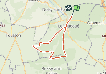
Tour Wandern von 13,4 km verfügbar auf Île-de-France, Seine-et-Marne, Le Vaudoué. Diese Tour wird von jll7513 vorgeschlagen.
Beschreibung
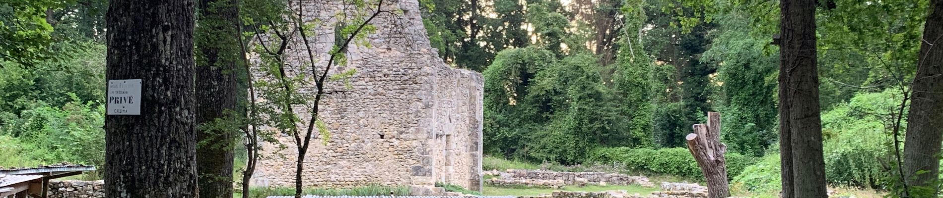
On se gare et on démarre du parking "Le Mée" en bordure de la forêt de Fontainebleau. Ensuite circuit sympa en forêt sur la première moitié puis entre bordure de champs et lisières de bois pour la suite. On a l'occasion de voir une ferme de templiers.
Ort
Land:
France
Region :
Île-de-France
Abteilung/Provinz :
Seine-et-Marne
Kommune :
Le Vaudoué
Standort:
Unknown
Gehen Sie:(Dec)
Gehen Sie:(UTM)
464942 ; 5356825 (31U) N.
Kommentare
Touren in der Umgebung
![Tour Wandern Le Vaudoué - Ultra 25 bosses - Photo](https://media.geolcdn.com/t/375/260/ext.jpg?maxdim=2&url=https%3A%2F%2Fservices.sitytrail.com%2FGeolivesWS%2FDownloadMedia.ashx%3FTrailID%3D243413%26Media%3Dfix__20140112104549.jpg)
![Wandern Wandern](https://static1.geolcdn.com/sitytour/trail-icons/101.png)
Ultra 25 bosses
Wandern
Schwierig
(1)
Le Vaudoué,
Île-de-France,
Seine-et-Marne,
France
![](/images/other/stat-length.png)
25 km | 32 km-effort
9h 2min
![](https://static1.geolcdn.com/siteimages/upload/files/16400158638029165_repeat_loop_refresh_sync_direction_icon.png)
Ja
![Tour Wandern Noisy-sur-École - M&R-121118 - 250Marches - Photo](https://media.geolcdn.com/t/375/260/ext.jpg?maxdim=2&url=https%3A%2F%2Fservices.sitytrail.com%2FGeolivesWS%2FDownloadMedia.ashx%3FTrailID%3D163348%26Media%3D20121118101634.jpeg)
![Wandern Wandern](https://static1.geolcdn.com/sitytour/trail-icons/101.png)
M&R-121118 - 250Marches
Wandern
Einfach
(1)
Noisy-sur-École,
Île-de-France,
Seine-et-Marne,
France
![](/images/other/stat-length.png)
14,3 km | 18,1 km-effort
3h 50min
![](https://static1.geolcdn.com/siteimages/upload/files/16400158638029165_repeat_loop_refresh_sync_direction_icon.png)
Ja
![Tour Wandern Milly-la-Forêt - Du parking de la Boulignère aux 100 marches via la ferme des Coquibus - Photo](https://media.geolcdn.com/t/375/260/2d4021ff-70a8-48ff-ad65-d6df60ccba59.jpg&format=jpg&maxdim=2)
![Wandern Wandern](https://static1.geolcdn.com/sitytour/trail-icons/101.png)
Du parking de la Boulignère aux 100 marches via la ferme des Coquibus
Wandern
Schwierig
(1)
Milly-la-Forêt,
Île-de-France,
Essonne,
France
![](/images/other/stat-length.png)
18,3 km | 22 km-effort
5h 0min
![](https://static1.geolcdn.com/siteimages/upload/files/16400158638029165_repeat_loop_refresh_sync_direction_icon.png)
Ja
![Tour Wandern Noisy-sur-École - Bois Rond#4 - Photo](https://media.geolcdn.com/t/375/260/7321184d-880d-445f-98b4-47f0ff0d82dd.jpg&format=jpg&maxdim=2)
![Wandern Wandern](https://static1.geolcdn.com/sitytour/trail-icons/101.png)
Bois Rond#4
Wandern
Sehr leicht
(1)
Noisy-sur-École,
Île-de-France,
Seine-et-Marne,
France
![](/images/other/stat-length.png)
8,8 km | 10,5 km-effort
2h 18min
![](https://static1.geolcdn.com/siteimages/upload/files/16400158638029165_repeat_loop_refresh_sync_direction_icon.png)
Ja
![Tour Wandern Noisy-sur-École - Les 25 Bosses - Gps en Forêt de Fontainebleau - Photo](https://media.geolcdn.com/t/375/260/ext.jpg?maxdim=2&url=https%3A%2F%2Fservices.sitytrail.com%2FGeolivesWS%2FDownloadMedia.ashx%3FTrailID%3D101528%26Media%3D1630_1.jpg)
![Wandern Wandern](https://static1.geolcdn.com/sitytour/trail-icons/101.png)
Les 25 Bosses - Gps en Forêt de Fontainebleau
Wandern
Sehr schwierig
(2)
Noisy-sur-École,
Île-de-France,
Seine-et-Marne,
France
![](/images/other/stat-length.png)
17,6 km | 23 km-effort
4h 45min
![](https://static1.geolcdn.com/siteimages/upload/files/16400158638029165_repeat_loop_refresh_sync_direction_icon.png)
Ja
![Tour Zu Fuß Le Vaudoué - Boucle Le Vaudoué - Photo](https://media.geolcdn.com/t/375/260/d05a3ec5-b137-48e5-a689-019375766e60.jpg&format=jpg&maxdim=2)
![Zu Fuß Zu Fuß](https://static1.geolcdn.com/sitytour/trail-icons/100.png)
Boucle Le Vaudoué
Zu Fuß
Medium
Le Vaudoué,
Île-de-France,
Seine-et-Marne,
France
![](/images/other/stat-length.png)
17,4 km | 21 km-effort
4h 47min
![](https://static1.geolcdn.com/siteimages/upload/files/16400158638029165_repeat_loop_refresh_sync_direction_icon.png)
Ja
![Tour Wandern Noisy-sur-École - Boucle 24 km Fontainebleau Arbonne - Photo](https://media.geolcdn.com/t/375/260/5aaa62f0-dc57-4770-a77a-231413885a94.jpg&format=jpg&maxdim=2)
![Wandern Wandern](https://static1.geolcdn.com/sitytour/trail-icons/101.png)
Boucle 24 km Fontainebleau Arbonne
Wandern
Einfach
Noisy-sur-École,
Île-de-France,
Seine-et-Marne,
France
![](/images/other/stat-length.png)
25 km | 31 km-effort
5h 52min
![](https://static1.geolcdn.com/siteimages/upload/files/16400158638029165_repeat_loop_refresh_sync_direction_icon.png)
Ja
![Tour Wandern Milly-la-Forêt - Boucle 29 km Milly La Forêt - Le Vaudoué - Tousson - Photo](https://media.geolcdn.com/t/375/260/3058c3db-123e-4ec5-b295-1e7b4c8ce449.jpg&format=jpg&maxdim=2)
![Wandern Wandern](https://static1.geolcdn.com/sitytour/trail-icons/101.png)
Boucle 29 km Milly La Forêt - Le Vaudoué - Tousson
Wandern
Schwierig
Milly-la-Forêt,
Île-de-France,
Essonne,
France
![](/images/other/stat-length.png)
29 km | 33 km-effort
5h 56min
![](https://static1.geolcdn.com/siteimages/upload/files/16400158638029165_repeat_loop_refresh_sync_direction_icon.png)
Ja
![Tour Wandern Noisy-sur-École - Noisy sur Ecole / Coquibus - Photo](https://media.geolcdn.com/t/375/260/9f6ffc55-2cbc-4988-8e49-be93fd15ba38.jpg&format=jpg&maxdim=2)
![Wandern Wandern](https://static1.geolcdn.com/sitytour/trail-icons/101.png)
Noisy sur Ecole / Coquibus
Wandern
Medium
Noisy-sur-École,
Île-de-France,
Seine-et-Marne,
France
![](/images/other/stat-length.png)
21 km | 26 km-effort
5h 20min
![](https://static1.geolcdn.com/siteimages/upload/files/16400158638029165_repeat_loop_refresh_sync_direction_icon.png)
Ja