![](/images/other/stat-length.png)
![Tour Wandern Bex - Tour du miroir d'Argentine - Photo](https://media.geolcdn.com/t/1900/400/a11a4556-d584-4f15-acfa-cb865f305df7.jpg&format=pjpeg&maxdim=2)
Tour du miroir d'Argentine
perenhout
Benutzer
![Länge](/images/other/stat-length.png)
Länge
16,8 km
![Maximale Höhe](https://static1.geolcdn.com/siteimages/upload/files/1508320355ic_sort_altitude_max_24dp.png)
Maximale Höhe
2045 m
![Positive Höhendifferenz](https://static1.geolcdn.com/siteimages/upload/files/1508320355ic_sort_den_pos_24dp.png)
Positive Höhendifferenz
1009 m
![Km-Effort](/images/other/stat-length.png)
Km-Effort
30 km
![Min. Höhe](https://static1.geolcdn.com/siteimages/upload/files/1508320355ic_sort_altitude_min_24dp.png)
Min. Höhe
1350 m
![Negative Höhendifferenz](https://static1.geolcdn.com/siteimages/upload/files/1508320355ic_sort_den_neg_24dp.png)
Negative Höhendifferenz
1008 m
![Boucle](https://static1.geolcdn.com/siteimages/upload/files/16400158638029165_repeat_loop_refresh_sync_direction_icon.png)
Boucle
Ja
Erstellungsdatum :
2021-07-26 06:29:49.569
Letzte Änderung :
2021-07-26 14:40:38.29
![Wandern](https://static1.geolcdn.com/sitytour/trail-icons/101.png)
7h05
Schwierigkeit : Sehr schwierig
![Scannen Sie diesen QR-Code, um die Tour in der SityTrail-Anwendung zu öffnen](https://capi.geolives.com/qq0zvz2zws4bq2lad0pu/sitytour/trails/2874740/qr.png?size=200)
Kostenlosegpshiking-Anwendung
Über SityTrail
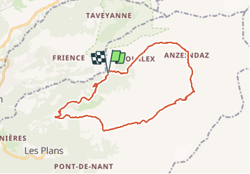
Tour Wandern von 16,8 km verfügbar auf Waadt, District d'Aigle, Bex. Diese Tour wird von perenhout vorgeschlagen.
Beschreibung
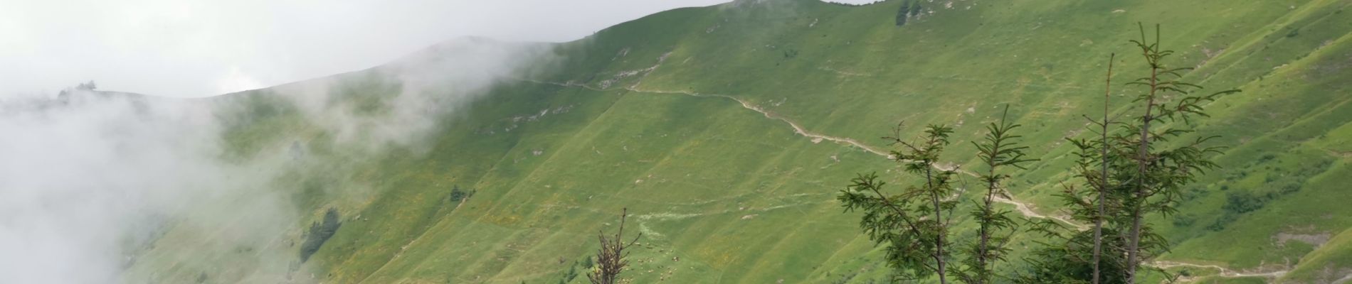
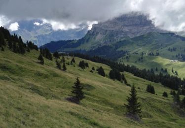
Très belle rando. Le retour par le creux des Mas est difficile, glissant et boueux mais permet d'éviter la descente classique qui est très raide au début.
Vues magnifiques sur les Muveran.
Pour randonneurs aux pieds sûrs.
Ort
Land:
Switzerland
Region :
Waadt
Abteilung/Provinz :
District d'Aigle
Kommune :
Bex
Standort:
Unknown
Gehen Sie:(Dec)
Gehen Sie:(UTM)
355377 ; 5127274 (32T) N.
Kommentare
Touren in der Umgebung
![Tour Wandern Olun - st_bg_villars1 - Photo](https://media.geolcdn.com/t/375/260/ext.jpg?maxdim=2&url=https%3A%2F%2Fstatic1.geolcdn.com%2Fsiteimages%2Fupload%2Ffiles%2F1553511878bg_sport_marche.png)
![Wandern Wandern](https://static1.geolcdn.com/sitytour/trail-icons/101.png)
st_bg_villars1
Wandern
Sehr leicht
Olun,
Waadt,
District d'Aigle,
Switzerland
![](/images/other/stat-length.png)
5,6 km | 8,3 km-effort
Unbekannt
![](https://static1.geolcdn.com/siteimages/upload/files/16400158638029165_repeat_loop_refresh_sync_direction_icon.png)
Nein
![Tour Wandern Bex - Bex (Genferseegebiet) - Photo](https://media.geolcdn.com/t/375/260/ext.jpg?maxdim=2&url=https%3A%2F%2Fstatic1.geolcdn.com%2Fsiteimages%2Fupload%2Ffiles%2F1553511878bg_sport_marche.png)
![Wandern Wandern](https://static1.geolcdn.com/sitytour/trail-icons/101.png)
Bex (Genferseegebiet)
Wandern
Sehr leicht
Bex,
Waadt,
District d'Aigle,
Switzerland
![](/images/other/stat-length.png)
10,5 km | 18,6 km-effort
5h 55min
![](https://static1.geolcdn.com/siteimages/upload/files/16400158638029165_repeat_loop_refresh_sync_direction_icon.png)
Ja
![Tour Laufen Gryon - Mxalps - Photo](https://media.geolcdn.com/t/375/260/ext.jpg?maxdim=2&url=https%3A%2F%2Fstatic1.geolcdn.com%2Fsiteimages%2Fupload%2Ffiles%2F1524743154running.jpg)
![Laufen Laufen](https://static1.geolcdn.com/sitytour/trail-icons/103.png)
Mxalps
Laufen
Schwierig
Gryon,
Waadt,
District d'Aigle,
Switzerland
![](/images/other/stat-length.png)
61 km | 116 km-effort
10h 0min
![](https://static1.geolcdn.com/siteimages/upload/files/16400158638029165_repeat_loop_refresh_sync_direction_icon.png)
Nein
![Tour Laufen Gryon - Mxalps - Photo](https://media.geolcdn.com/t/375/260/ext.jpg?maxdim=2&url=https%3A%2F%2Fstatic1.geolcdn.com%2Fsiteimages%2Fupload%2Ffiles%2F1524743154running.jpg)
![Laufen Laufen](https://static1.geolcdn.com/sitytour/trail-icons/103.png)
Mxalps
Laufen
Schwierig
Gryon,
Waadt,
District d'Aigle,
Switzerland
![](/images/other/stat-length.png)
61 km | 116 km-effort
Unbekannt
![](https://static1.geolcdn.com/siteimages/upload/files/16400158638029165_repeat_loop_refresh_sync_direction_icon.png)
Nein
![Tour Wandern Olun - Circuit Col de la Croix - les lacs - Bretaye 13.07.17 - Photo](https://media.geolcdn.com/t/375/260/ext.jpg?maxdim=2&url=https%3A%2F%2Fservices.sitytrail.com%2FGeolivesWS%2FDownloadMedia.ashx%3FTrailID%3D788883%26Media%3D3f106388-23e5-435d-b903-dafefc596efe.jpg)
![Wandern Wandern](https://static1.geolcdn.com/sitytour/trail-icons/101.png)
Circuit Col de la Croix - les lacs - Bretaye 13.07.17
Wandern
Medium
Olun,
Waadt,
District d'Aigle,
Switzerland
![](/images/other/stat-length.png)
13,8 km | 21 km-effort
4h 27min
![](https://static1.geolcdn.com/siteimages/upload/files/16400158638029165_repeat_loop_refresh_sync_direction_icon.png)
Ja
![Tour Wandern Olun - Col de la Croix - Photo](https://media.geolcdn.com/t/375/260/ext.jpg?maxdim=2&url=https%3A%2F%2Fstatic1.geolcdn.com%2Fsiteimages%2Fupload%2Ffiles%2F1553511878bg_sport_marche.png)
![Wandern Wandern](https://static1.geolcdn.com/sitytour/trail-icons/101.png)
Col de la Croix
Wandern
Medium
Olun,
Waadt,
District d'Aigle,
Switzerland
![](/images/other/stat-length.png)
11,9 km | 18,1 km-effort
3h 51min
![](https://static1.geolcdn.com/siteimages/upload/files/16400158638029165_repeat_loop_refresh_sync_direction_icon.png)
Ja
![Tour Andere Aktivitäten Olun - HL va du col de Bretaye à Vers-l''Eglise - Photo](https://media.geolcdn.com/t/375/260/ext.jpg?maxdim=2&url=https%3A%2F%2Fstatic1.geolcdn.com%2Fsiteimages%2Fupload%2Ffiles%2F1545311037marcheuse_200dpi.jpg)
![Andere Aktivitäten Andere Aktivitäten](https://static1.geolcdn.com/sitytour/trail-icons/900.png)
HL va du col de Bretaye à Vers-l''Eglise
Andere Aktivitäten
Sehr leicht
Olun,
Waadt,
District d'Aigle,
Switzerland
![](/images/other/stat-length.png)
10,6 km | 14,7 km-effort
3h 0min
![](https://static1.geolcdn.com/siteimages/upload/files/16400158638029165_repeat_loop_refresh_sync_direction_icon.png)
Nein
![Tour Wandern Bex - Bex, Vallon de Nant - Photo](https://media.geolcdn.com/t/375/260/ext.jpg?maxdim=2&url=https%3A%2F%2Fstatic1.geolcdn.com%2Fsiteimages%2Fupload%2Ffiles%2F1553511878bg_sport_marche.png)
![Wandern Wandern](https://static1.geolcdn.com/sitytour/trail-icons/101.png)
Bex, Vallon de Nant
Wandern
Sehr leicht
Bex,
Waadt,
District d'Aigle,
Switzerland
![](/images/other/stat-length.png)
10 km | 17,1 km-effort
4h 30min
![](https://static1.geolcdn.com/siteimages/upload/files/16400158638029165_repeat_loop_refresh_sync_direction_icon.png)
Ja
![Tour Mountainbike Bex - Wallis North 3 : La Vare - Ardon - Photo](https://media.geolcdn.com/t/375/260/ext.jpg?maxdim=2&url=https%3A%2F%2Fstatic1.geolcdn.com%2Fsiteimages%2Fupload%2Ffiles%2F1524743154velo.jpg)
![Mountainbike Mountainbike](https://static1.geolcdn.com/sitytour/trail-icons/202.png)
Wallis North 3 : La Vare - Ardon
Mountainbike
Sehr leicht
Bex,
Waadt,
District d'Aigle,
Switzerland
![](/images/other/stat-length.png)
22 km | 35 km-effort
2h 31min
![](https://static1.geolcdn.com/siteimages/upload/files/16400158638029165_repeat_loop_refresh_sync_direction_icon.png)
Nein