![](/images/other/stat-length.png)
![Tour Wandern Saint-Sauveur-Camprieu - Abîme de Bramabiau - Camprieu - Abbaye du Bonheur - Photo](https://media.geolcdn.com/t/1900/400/5acfbfd6-ce8c-4407-bafc-8d06ea976db3.jpg&format=pjpeg&maxdim=2)
Abîme de Bramabiau - Camprieu - Abbaye du Bonheur
Bart2015
Benutzer
![Länge](/images/other/stat-length.png)
![Maximale Höhe](https://static1.geolcdn.com/siteimages/upload/files/1508320355ic_sort_altitude_max_24dp.png)
![Positive Höhendifferenz](https://static1.geolcdn.com/siteimages/upload/files/1508320355ic_sort_den_pos_24dp.png)
![Km-Effort](/images/other/stat-length.png)
![Min. Höhe](https://static1.geolcdn.com/siteimages/upload/files/1508320355ic_sort_altitude_min_24dp.png)
![Negative Höhendifferenz](https://static1.geolcdn.com/siteimages/upload/files/1508320355ic_sort_den_neg_24dp.png)
![Boucle](https://static1.geolcdn.com/siteimages/upload/files/16400158638029165_repeat_loop_refresh_sync_direction_icon.png)
![Wandern](https://static1.geolcdn.com/sitytour/trail-icons/101.png)
4h07
Schwierigkeit : Einfach
![Scannen Sie diesen QR-Code, um die Tour in der SityTrail-Anwendung zu öffnen](https://capi.geolives.com/qq0zvz2zws4bq2lad0pu/sitytour/trails/2874620/qr.png?size=200)
Kostenlosegpshiking-Anwendung
Über SityTrail
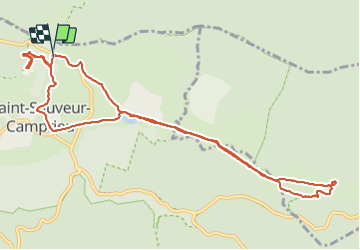
Tour Wandern von 12,8 km verfügbar auf Okzitanien, Gard, Saint-Sauveur-Camprieu. Diese Tour wird von Bart2015 vorgeschlagen.
Beschreibung
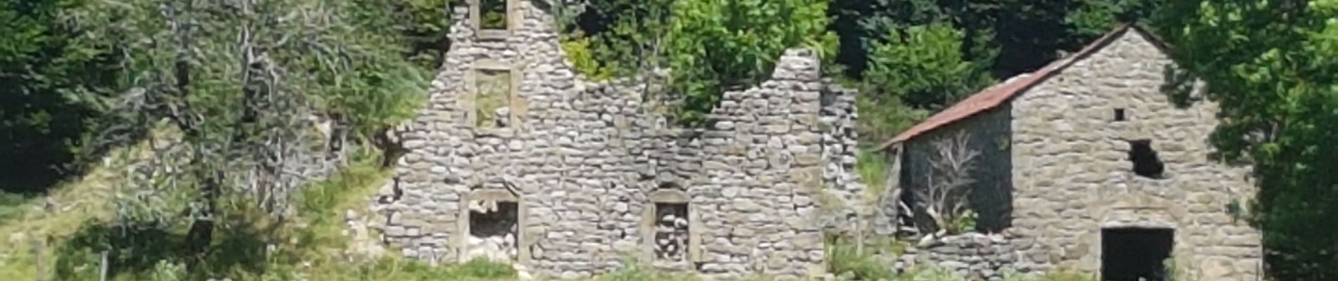
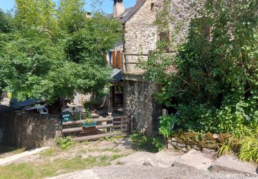
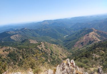
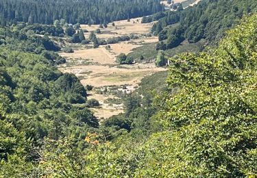
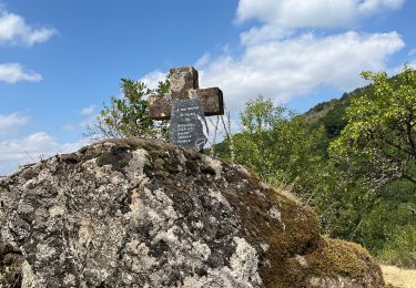
Bienvenue dans la randonnée du Bonheur. Départ à proximité de l'abîme du Bramabiau pour découvrir une magnifique cascade et sa grotte. Si vous avez pris les billets (visite durée 1h30, prévoir une petite laine car 10°). Balade ensuite dans Camprieu, ce circuit remonte la vallée du Bonheur en longeant le cours d'eau du même nom jusqu'aux vestiges romans de l'abbaye médiévale du Bonheur fondée en 1002.
Bonne randonnée ...
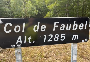
Rectifier début- Voir départ côté Abbaye ? Visite abîmé 1h30 ttes 30 mn, s'habiller car 10°
Ort
Kommentare
Touren in der Umgebung
![Tour Wandern Saint-Sauveur-Camprieu - Dourbies Camprieu boucle - Photo](https://media.geolcdn.com/t/375/260/773150fb-e481-46d1-aed3-630ac5bd1b85.jpg&format=jpg&maxdim=2)
![Wandern Wandern](https://static1.geolcdn.com/sitytour/trail-icons/101.png)
Wandern
![](/images/other/stat-length.png)
![](https://static1.geolcdn.com/siteimages/upload/files/16400158638029165_repeat_loop_refresh_sync_direction_icon.png)
![Tour Wandern Saint-Sauveur-Camprieu - rando du bonheur - Photo](https://media.geolcdn.com/t/375/260/8d654987-9f06-4f64-a843-d27ca16ef4d7.jpg&format=jpg&maxdim=2)
![Wandern Wandern](https://static1.geolcdn.com/sitytour/trail-icons/101.png)
Wandern
![](/images/other/stat-length.png)
![](https://static1.geolcdn.com/siteimages/upload/files/16400158638029165_repeat_loop_refresh_sync_direction_icon.png)
![Tour Wandern Saint-Sauveur-Camprieu - les monts de Saint sauveur de camprieu - Photo](https://media.geolcdn.com/t/375/260/b7332eb8-007f-4971-afe2-01fb314b7900.jpg&format=jpg&maxdim=2)
![Wandern Wandern](https://static1.geolcdn.com/sitytour/trail-icons/101.png)
Wandern
![](/images/other/stat-length.png)
![](https://static1.geolcdn.com/siteimages/upload/files/16400158638029165_repeat_loop_refresh_sync_direction_icon.png)
![Tour Wandern Val-d'Aigoual - les cascades de l'aigoual par seyrerede - Photo](https://media.geolcdn.com/t/375/260/f9837145-dbac-42c7-abcf-7cbb3f01b62c.jpg&format=jpg&maxdim=2)
![Wandern Wandern](https://static1.geolcdn.com/sitytour/trail-icons/101.png)
Wandern
![](/images/other/stat-length.png)
![](https://static1.geolcdn.com/siteimages/upload/files/16400158638029165_repeat_loop_refresh_sync_direction_icon.png)
![Tour Wandern Val-d'Aigoual - serreyrede à l aigoual par arboretum - Photo](https://media.geolcdn.com/t/375/260/2be9adc5-67d2-49de-acda-0293aa7a92e9.jpg&format=jpg&maxdim=2)
![Wandern Wandern](https://static1.geolcdn.com/sitytour/trail-icons/101.png)
Wandern
![](/images/other/stat-length.png)
![](https://static1.geolcdn.com/siteimages/upload/files/16400158638029165_repeat_loop_refresh_sync_direction_icon.png)
![Tour Wandern Val-d'Aigoual - Serreyrede-caumette-Pra peyrot - Photo](https://media.geolcdn.com/t/375/260/4bd7c368-ffdb-4e2f-8b71-be78c10adff8.jpg&format=jpg&maxdim=2)
![Wandern Wandern](https://static1.geolcdn.com/sitytour/trail-icons/101.png)
Wandern
![](/images/other/stat-length.png)
![](https://static1.geolcdn.com/siteimages/upload/files/16400158638029165_repeat_loop_refresh_sync_direction_icon.png)
![Tour Wandern Val-d'Aigoual - PLO de VALBELLE - Photo](https://media.geolcdn.com/t/375/260/5c0bf513-bea3-4d2c-8dc7-aabb01646242.jpg&format=jpg&maxdim=2)
![Wandern Wandern](https://static1.geolcdn.com/sitytour/trail-icons/101.png)
Wandern
![](/images/other/stat-length.png)
![](https://static1.geolcdn.com/siteimages/upload/files/16400158638029165_repeat_loop_refresh_sync_direction_icon.png)
![Tour Wandern Saint-Sauveur-Camprieu - Col du FAUBEL le Puey Barbut - Photo](https://media.geolcdn.com/t/375/260/98f69e29-1642-4fb5-a7e9-9dcbd06f1735.jpg&format=jpg&maxdim=2)
![Wandern Wandern](https://static1.geolcdn.com/sitytour/trail-icons/101.png)
Wandern
![](/images/other/stat-length.png)
![](https://static1.geolcdn.com/siteimages/upload/files/16400158638029165_repeat_loop_refresh_sync_direction_icon.png)
![Tour Wandern Saint-Sauveur-Camprieu - Camprieu col des Ubertes , col du suquet les mon - Photo](https://media.geolcdn.com/t/375/260/25c437fb-934c-4918-a66d-7fc07a42861e.jpg&format=jpg&maxdim=2)
![Wandern Wandern](https://static1.geolcdn.com/sitytour/trail-icons/101.png)
Wandern
![](/images/other/stat-length.png)
![](https://static1.geolcdn.com/siteimages/upload/files/16400158638029165_repeat_loop_refresh_sync_direction_icon.png)