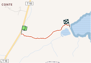
![](/images/other/stat-length.png)
![Tour Wandern Porto-Vecchio - porto nuovo 2021 - Photo](https://media.geolcdn.com/t/1900/400/ext.pjpeg?maxdim=2&url=https%3A%2F%2Fstatic1.geolcdn.com%2Fsiteimages%2Fupload%2Ffiles%2F1553511878bg_sport_marche.png)
porto nuovo 2021
philippenl
Benutzer
![Länge](/images/other/stat-length.png)
![Maximale Höhe](https://static1.geolcdn.com/siteimages/upload/files/1508320355ic_sort_altitude_max_24dp.png)
![Positive Höhendifferenz](https://static1.geolcdn.com/siteimages/upload/files/1508320355ic_sort_den_pos_24dp.png)
![Km-Effort](/images/other/stat-length.png)
![Min. Höhe](https://static1.geolcdn.com/siteimages/upload/files/1508320355ic_sort_altitude_min_24dp.png)
![Negative Höhendifferenz](https://static1.geolcdn.com/siteimages/upload/files/1508320355ic_sort_den_neg_24dp.png)
![Boucle](https://static1.geolcdn.com/siteimages/upload/files/16400158638029165_repeat_loop_refresh_sync_direction_icon.png)
![Wandern](https://static1.geolcdn.com/sitytour/trail-icons/101.png)
31m
Schwierigkeit : Einfach
![Scannen Sie diesen QR-Code, um die Tour in der SityTrail-Anwendung zu öffnen](https://capi.geolives.com/qq0zvz2zws4bq2lad0pu/sitytour/trails/2873814/qr.png?size=200)
Kostenlosegpshiking-Anwendung
Über SityTrail
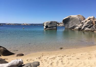
Tour Wandern von 1,8 km verfügbar auf Korsika, Südkorsika, Porto-Vecchio. Diese Tour wird von philippenl vorgeschlagen.
Beschreibung
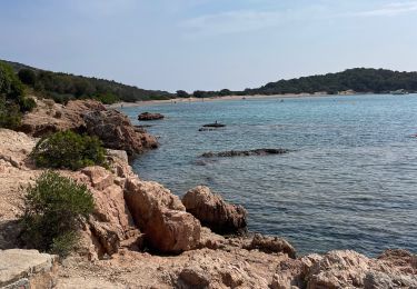
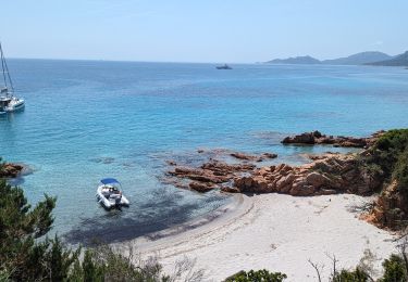
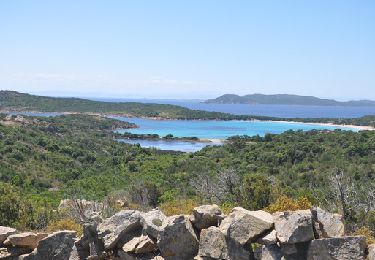
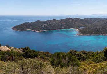
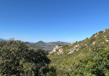
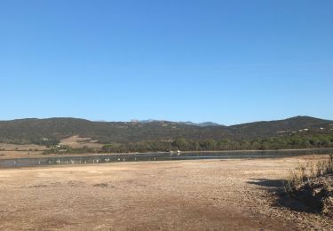
Sentier historique qui rejoint le golfe de Porto Nuovo sur le versant opposé à la (horrible et inondable) piste forestière qui part de la carrière. Laisser la voiture sur le dégagement de la T10 et, à quelques dizaines de mètres, rejoindre le beau sentier (une trace orange sur un piquet) dont le départ se situe dans le virage de la route. Environ 30 mn de marche jusqu'à Porto Nuovo avec de jolis points de vue sur le golfe.
Ort
Kommentare
Touren in der Umgebung
![Tour sport Bonifacio - A - Photo](https://media.geolcdn.com/t/375/260/53babdc6-f700-4da0-97b7-b0fa31aa7fc1.jpg&format=jpg&maxdim=2)
![Tour Wandern Porto-Vecchio - 2023-06-24 Marche Plage Santa Giulia vers Palombaggia - Photo](https://media.geolcdn.com/t/375/260/ec05fb62-b924-40f8-8e78-4507cb0c7507.jpg&format=jpg&maxdim=2)
![Wandern Wandern](https://static1.geolcdn.com/sitytour/trail-icons/101.png)
Wandern
![](/images/other/stat-length.png)
![](https://static1.geolcdn.com/siteimages/upload/files/16400158638029165_repeat_loop_refresh_sync_direction_icon.png)
![Tour Wandern Bonifacio - Rondinara-Sponsaglia - Photo](https://media.geolcdn.com/t/375/260/ext.jpg?maxdim=2&url=https%3A%2F%2Fservices.sitytrail.com%2FGeolivesWS%2FDownloadMedia.ashx%3FTrailID%3D305220%26Media%3Dbd0fa300-9446-45b9-b53e-0af361ffdd1f.JPG)
![Wandern Wandern](https://static1.geolcdn.com/sitytour/trail-icons/101.png)
Wandern
![](/images/other/stat-length.png)
![](https://static1.geolcdn.com/siteimages/upload/files/16400158638029165_repeat_loop_refresh_sync_direction_icon.png)
![Tour Wandern Porto-Vecchio - Traversée Porto Novo/Santa Giulia par les crêtes - Photo](https://media.geolcdn.com/t/375/260/838d8cd3-5fef-4c5c-9496-e2e65f6b0ec3.jpg&format=jpg&maxdim=2)
![Wandern Wandern](https://static1.geolcdn.com/sitytour/trail-icons/101.png)
Wandern
![](/images/other/stat-length.png)
![](https://static1.geolcdn.com/siteimages/upload/files/16400158638029165_repeat_loop_refresh_sync_direction_icon.png)
![Tour Wandern Porto-Vecchio - La boucle de Santa Giulia - Photo](https://media.geolcdn.com/t/375/260/86cc7fc1-b2a8-4c01-bf35-d77a8732d07c.jpg&format=jpg&maxdim=2)
![Wandern Wandern](https://static1.geolcdn.com/sitytour/trail-icons/101.png)
Wandern
![](/images/other/stat-length.png)
![](https://static1.geolcdn.com/siteimages/upload/files/16400158638029165_repeat_loop_refresh_sync_direction_icon.png)
![Tour Wandern Porto-Vecchio - Santa gjulli - Photo](https://media.geolcdn.com/t/375/260/9cfb66d6-50a5-4511-bf02-d270694e7165.jpg&format=jpg&maxdim=2)
![Wandern Wandern](https://static1.geolcdn.com/sitytour/trail-icons/101.png)
![Tour Wandern Porto-Vecchio - Santa giulia - Photo](https://media.geolcdn.com/t/375/260/ded88894-21d4-4416-bbcb-7cef8361e348.jpg&format=jpg&maxdim=2)
![Wandern Wandern](https://static1.geolcdn.com/sitytour/trail-icons/101.png)
Wandern
![](/images/other/stat-length.png)
![](https://static1.geolcdn.com/siteimages/upload/files/16400158638029165_repeat_loop_refresh_sync_direction_icon.png)
![Tour Andere Aktivitäten Sotta - peu di Cani - Photo](https://media.geolcdn.com/t/375/260/ext.jpg?maxdim=2&url=https%3A%2F%2Fservices.sitytrail.com%2FGeolivesWS%2FDownloadMedia.ashx%3FTrailID%3D761647%26Media%3D20170527145932.jpg)
![Andere Aktivitäten Andere Aktivitäten](https://static1.geolcdn.com/sitytour/trail-icons/900.png)
Andere Aktivitäten
![](/images/other/stat-length.png)
![](https://static1.geolcdn.com/siteimages/upload/files/16400158638029165_repeat_loop_refresh_sync_direction_icon.png)
![Tour Wandern Bonifacio - La rondinara - Photo](https://media.geolcdn.com/t/375/260/ext.jpg?maxdim=2&url=https%3A%2F%2Fstatic1.geolcdn.com%2Fsiteimages%2Fupload%2Ffiles%2F1553511878bg_sport_marche.png)
![Wandern Wandern](https://static1.geolcdn.com/sitytour/trail-icons/101.png)
Wandern
![](/images/other/stat-length.png)
![](https://static1.geolcdn.com/siteimages/upload/files/16400158638029165_repeat_loop_refresh_sync_direction_icon.png)