![](/images/other/stat-length.png)
![Tour Wandern Épinal - humbertois les ,2lacs - Photo](https://media.geolcdn.com/t/1900/400/c469247b-9bb0-491c-9204-6b2729eb7b0d.jpg&format=pjpeg&maxdim=2)
humbertois les ,2lacs
BernardHumeau
Benutzer
![Länge](/images/other/stat-length.png)
Länge
7,3 km
![Maximale Höhe](https://static1.geolcdn.com/siteimages/upload/files/1508320355ic_sort_altitude_max_24dp.png)
Maximale Höhe
472 m
![Positive Höhendifferenz](https://static1.geolcdn.com/siteimages/upload/files/1508320355ic_sort_den_pos_24dp.png)
Positive Höhendifferenz
120 m
![Km-Effort](/images/other/stat-length.png)
Km-Effort
8,9 km
![Min. Höhe](https://static1.geolcdn.com/siteimages/upload/files/1508320355ic_sort_altitude_min_24dp.png)
Min. Höhe
418 m
![Negative Höhendifferenz](https://static1.geolcdn.com/siteimages/upload/files/1508320355ic_sort_den_neg_24dp.png)
Negative Höhendifferenz
111 m
![Boucle](https://static1.geolcdn.com/siteimages/upload/files/16400158638029165_repeat_loop_refresh_sync_direction_icon.png)
Boucle
Ja
Erstellungsdatum :
2021-07-25 13:24:32.0
Letzte Änderung :
2021-07-25 17:09:29.569
![Wandern](https://static1.geolcdn.com/sitytour/trail-icons/101.png)
1h55
Schwierigkeit : Medium
![Scannen Sie diesen QR-Code, um die Tour in der SityTrail-Anwendung zu öffnen](https://capi.geolives.com/qq0zvz2zws4bq2lad0pu/sitytour/trails/2873700/qr.png?size=200)
Kostenlosegpshiking-Anwendung
Über SityTrail
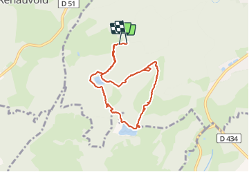
Tour Wandern von 7,3 km verfügbar auf Großer Osten, Vogesen, Épinal. Diese Tour wird von BernardHumeau vorgeschlagen.
Beschreibung
P. ferme de Humbertois.
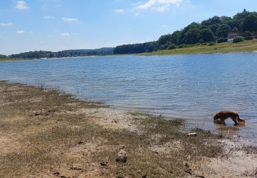
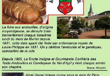
Petite rando en forêt et prairies par deux petits lacs ( Riéfaing, Bult). Balisage du Club Vosgien Epinal.
Ort
Land:
France
Region :
Großer Osten
Abteilung/Provinz :
Vogesen
Kommune :
Épinal
Standort:
Unknown
Gehen Sie:(Dec)
Gehen Sie:(UTM)
307184 ; 5334752 (32U) N.
Kommentare
Touren in der Umgebung
![Tour Wandern Épinal - Epinal - Photo](https://media.geolcdn.com/t/375/260/940302e4-e305-4d1c-a286-7e159c6cde8b.jpg&format=jpg&maxdim=2)
![Wandern Wandern](https://static1.geolcdn.com/sitytour/trail-icons/101.png)
![Tour Wandern Chaumousey - Bouzey, côté abbaye - Photo](https://media.geolcdn.com/t/375/260/7bbec264-6140-414e-b70b-a7b14fa5a444.jpg&format=jpg&maxdim=2)
![Wandern Wandern](https://static1.geolcdn.com/sitytour/trail-icons/101.png)
Bouzey, côté abbaye
Wandern
Medium
Chaumousey,
Großer Osten,
Vogesen,
France
![](/images/other/stat-length.png)
6,1 km | 7,5 km-effort
1h 40min
![](https://static1.geolcdn.com/siteimages/upload/files/16400158638029165_repeat_loop_refresh_sync_direction_icon.png)
Ja
![Tour Wandern Épinal - 2016 03 22 - Photo](https://media.geolcdn.com/t/375/260/ext.jpg?maxdim=2&url=https%3A%2F%2Fservices.sitytrail.com%2FGeolivesWS%2FDownloadMedia.ashx%3FTrailID%3D542217%26Media%3Dfix__20160322163522.jpg)
![Wandern Wandern](https://static1.geolcdn.com/sitytour/trail-icons/101.png)
![Tour Andere Aktivitäten Épinal - Grand Est - Ligne 18 - Epinal St Diè - Photo](https://media.geolcdn.com/t/375/260/ext.jpg?maxdim=2&url=https%3A%2F%2Fservices.sitytrail.com%2FGeolivesWS%2FDownloadMedia.ashx%3FTrailID%3D449149%26Media%3D79b8c567-20fe-4c86-8015-3c376b29db07.jpg)
![Andere Aktivitäten Andere Aktivitäten](https://static1.geolcdn.com/sitytour/trail-icons/900.png)
Grand Est - Ligne 18 - Epinal St Diè
Andere Aktivitäten
Sehr leicht
Épinal,
Großer Osten,
Vogesen,
France
![](/images/other/stat-length.png)
61 km | 68 km-effort
5min
![](https://static1.geolcdn.com/siteimages/upload/files/16400158638029165_repeat_loop_refresh_sync_direction_icon.png)
Nein
![Tour Andere Aktivitäten Épinal - Grand Est - Ligne 18,7 - Epinal Remiremont - Photo](https://media.geolcdn.com/t/375/260/ext.jpg?maxdim=2&url=https%3A%2F%2Fservices.sitytrail.com%2FGeolivesWS%2FDownloadMedia.ashx%3FTrailID%3D448459%26Media%3Da6bb1b53-2dd3-47d4-9651-180d18084675.jpg)
![Andere Aktivitäten Andere Aktivitäten](https://static1.geolcdn.com/sitytour/trail-icons/900.png)
Grand Est - Ligne 18,7 - Epinal Remiremont
Andere Aktivitäten
Sehr leicht
Épinal,
Großer Osten,
Vogesen,
France
![](/images/other/stat-length.png)
27 km | 31 km-effort
5min
![](https://static1.geolcdn.com/siteimages/upload/files/16400158638029165_repeat_loop_refresh_sync_direction_icon.png)
Nein
![Tour Wandern Chantraine - De Chantraine à Bouzey - Photo](https://media.geolcdn.com/t/375/260/ext.jpg?maxdim=2&url=https%3A%2F%2Fservices.sitytrail.com%2FGeolivesWS%2FDownloadMedia.ashx%3FTrailID%3D437288%26Media%3Dfix__20150623165101.jpg)
![Wandern Wandern](https://static1.geolcdn.com/sitytour/trail-icons/101.png)
De Chantraine à Bouzey
Wandern
Einfach
Chantraine,
Großer Osten,
Vogesen,
France
![](/images/other/stat-length.png)
14,6 km | 18,2 km-effort
3h 47min
![](https://static1.geolcdn.com/siteimages/upload/files/16400158638029165_repeat_loop_refresh_sync_direction_icon.png)
Ja
![Tour Wandern Sanchey - A la Découverte de BOUZEY - Photo](https://media.geolcdn.com/t/375/260/ext.jpg?maxdim=2&url=https%3A%2F%2Fservices.sitytrail.com%2FGeolivesWS%2FDownloadMedia.ashx%3FTrailID%3D370217%26Media%3Dfix__20141216154032.jpg)
![Wandern Wandern](https://static1.geolcdn.com/sitytour/trail-icons/101.png)
A la Découverte de BOUZEY
Wandern
Sehr leicht
Sanchey,
Großer Osten,
Vogesen,
France
![](/images/other/stat-length.png)
7,7 km | 9,3 km-effort
2h 4min
![](https://static1.geolcdn.com/siteimages/upload/files/16400158638029165_repeat_loop_refresh_sync_direction_icon.png)
Ja
![Tour Wandern Épinal - Aux Champs de Damas - Photo](https://media.geolcdn.com/t/375/260/ext.jpg?maxdim=2&url=https%3A%2F%2Fservices.sitytrail.com%2FGeolivesWS%2FDownloadMedia.ashx%3FTrailID%3D363702%26Media%3Dfix__20141118154921.jpg)
![Wandern Wandern](https://static1.geolcdn.com/sitytour/trail-icons/101.png)
Aux Champs de Damas
Wandern
Einfach
(2)
Épinal,
Großer Osten,
Vogesen,
France
![](/images/other/stat-length.png)
8,4 km | 10,3 km-effort
2h 17min
![](https://static1.geolcdn.com/siteimages/upload/files/16400158638029165_repeat_loop_refresh_sync_direction_icon.png)
Ja
![Tour Wandern Sanchey - Circuit du tour du Lac de Bouzey - Photo](https://media.geolcdn.com/t/375/260/ext.jpg?maxdim=2&url=https%3A%2F%2Fservices.sitytrail.com%2FGeolivesWS%2FDownloadMedia.ashx%3FTrailID%3D215026%26Media%3D15592_3.jpg)
![Wandern Wandern](https://static1.geolcdn.com/sitytour/trail-icons/101.png)
Circuit du tour du Lac de Bouzey
Wandern
Einfach
Sanchey,
Großer Osten,
Vogesen,
France
![](/images/other/stat-length.png)
7 km | 8,5 km-effort
1h 40min
![](https://static1.geolcdn.com/siteimages/upload/files/16400158638029165_repeat_loop_refresh_sync_direction_icon.png)
Ja