![](/images/other/stat-length.png)
![Tour Wandern Couëron - Nantes Lac de Beaulieu - Photo](https://media.geolcdn.com/t/1900/400/b93ef529-415a-406d-874d-d40c42a63c17.jpg&format=pjpeg&maxdim=2)
Nantes Lac de Beaulieu
jll7513
Benutzer
![Länge](/images/other/stat-length.png)
Länge
9,4 km
![Maximale Höhe](https://static1.geolcdn.com/siteimages/upload/files/1508320355ic_sort_altitude_max_24dp.png)
Maximale Höhe
44 m
![Positive Höhendifferenz](https://static1.geolcdn.com/siteimages/upload/files/1508320355ic_sort_den_pos_24dp.png)
Positive Höhendifferenz
105 m
![Km-Effort](/images/other/stat-length.png)
Km-Effort
10,8 km
![Min. Höhe](https://static1.geolcdn.com/siteimages/upload/files/1508320355ic_sort_altitude_min_24dp.png)
Min. Höhe
1 m
![Negative Höhendifferenz](https://static1.geolcdn.com/siteimages/upload/files/1508320355ic_sort_den_neg_24dp.png)
Negative Höhendifferenz
104 m
![Boucle](https://static1.geolcdn.com/siteimages/upload/files/16400158638029165_repeat_loop_refresh_sync_direction_icon.png)
Boucle
Ja
Erstellungsdatum :
2021-07-23 05:11:28.0
Letzte Änderung :
2021-07-25 06:36:45.354
![Wandern](https://static1.geolcdn.com/sitytour/trail-icons/101.png)
2h27
Schwierigkeit : Einfach
![Nordic Walking](https://static1.geolcdn.com/sitytour/trail-icons/102.png)
1h46
Schwierigkeit : Einfach
![Scannen Sie diesen QR-Code, um die Tour in der SityTrail-Anwendung zu öffnen](https://capi.geolives.com/qq0zvz2zws4bq2lad0pu/sitytour/trails/2870793/qr.png?size=200)
Kostenlosegpshiking-Anwendung
Über SityTrail
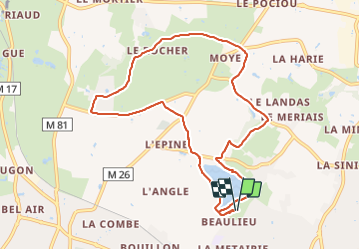
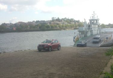
Tour Wandern von 9,4 km verfügbar auf Pays de la Loire, Loire-Atlantique, Couëron. Diese Tour wird von jll7513 vorgeschlagen.
Beschreibung
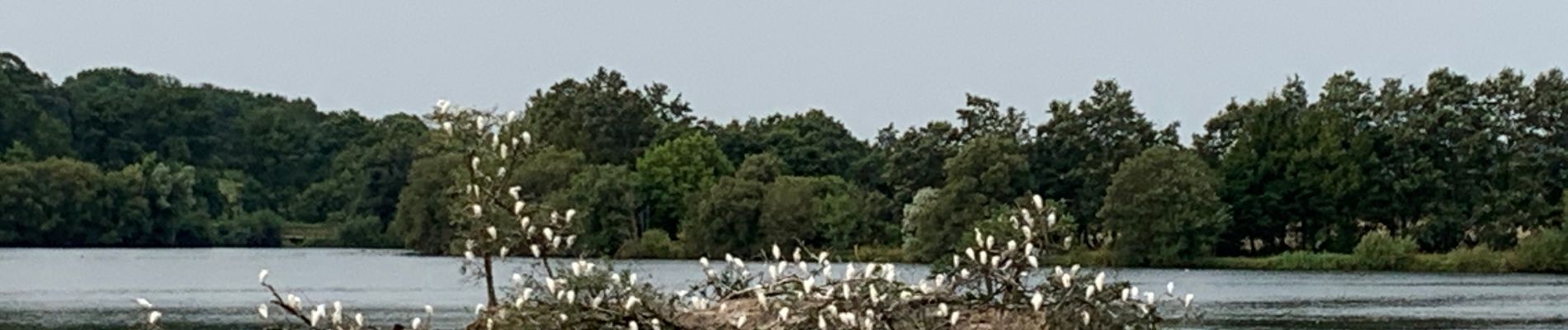
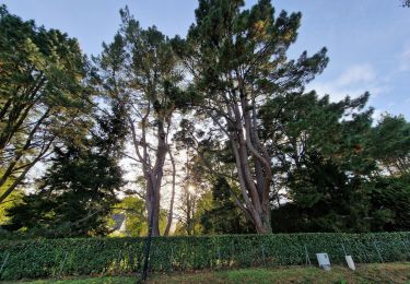
Départ et parking situé au bout d'un petit chemin de terre.Très beau parcours qui permet de faire le tour du lac, mais également de sillonner sur de très beaux sentiers. Très peu de route
Ort
Land:
France
Region :
Pays de la Loire
Abteilung/Provinz :
Loire-Atlantique
Kommune :
Couëron
Standort:
Unknown
Gehen Sie:(Dec)
Gehen Sie:(UTM)
598679 ; 5230518 (30T) N.
Kommentare
Touren in der Umgebung
![Tour Radtourismus Le Pellerin - Activity - Photo](https://media.geolcdn.com/t/375/260/ext.jpg?maxdim=2&url=https%3A%2F%2Fstatic1.geolcdn.com%2Fsiteimages%2Fupload%2Ffiles%2F1524743154velo.jpg)
![Radtourismus Radtourismus](https://static1.geolcdn.com/sitytour/trail-icons/204.png)
Activity
Radtourismus
Sehr leicht
(1)
Le Pellerin,
Pays de la Loire,
Loire-Atlantique,
France
![](/images/other/stat-length.png)
57 km | 62 km-effort
6h 0min
![](https://static1.geolcdn.com/siteimages/upload/files/16400158638029165_repeat_loop_refresh_sync_direction_icon.png)
Nein
![Tour Wandern Sautron - Les vallées du Cens et de la Chézine - Photo](https://media.geolcdn.com/t/375/260/05a85b83-dbfa-4b32-96d1-505606f1e466.jpg&format=jpg&maxdim=2)
![Wandern Wandern](https://static1.geolcdn.com/sitytour/trail-icons/101.png)
Les vallées du Cens et de la Chézine
Wandern
Medium
Sautron,
Pays de la Loire,
Loire-Atlantique,
France
![](/images/other/stat-length.png)
9,9 km | 11,4 km-effort
2h 4min
![](https://static1.geolcdn.com/siteimages/upload/files/16400158638029165_repeat_loop_refresh_sync_direction_icon.png)
Ja
![Tour Zu Fuß Bouguenais - La Roche Ballue - Photo](https://media.geolcdn.com/t/375/260/fe978ca7-737c-4da3-b5a6-561be870154c.jpeg&format=jpg&maxdim=2)
![Zu Fuß Zu Fuß](https://static1.geolcdn.com/sitytour/trail-icons/100.png)
La Roche Ballue
Zu Fuß
Einfach
Bouguenais,
Pays de la Loire,
Loire-Atlantique,
France
![](/images/other/stat-length.png)
10,7 km | 12,2 km-effort
2h 47min
![](https://static1.geolcdn.com/siteimages/upload/files/16400158638029165_repeat_loop_refresh_sync_direction_icon.png)
Ja
![Tour Wandern Couëron - boucle lac de beaulieu - Photo](https://media.geolcdn.com/t/375/260/ext.jpg?maxdim=2&url=https%3A%2F%2Fstatic1.geolcdn.com%2Fsiteimages%2Fupload%2Ffiles%2F1553511878bg_sport_marche.png)
![Wandern Wandern](https://static1.geolcdn.com/sitytour/trail-icons/101.png)
boucle lac de beaulieu
Wandern
Sehr schwierig
(1)
Couëron,
Pays de la Loire,
Loire-Atlantique,
France
![](/images/other/stat-length.png)
17,5 km | 19,6 km-effort
4h 34min
![](https://static1.geolcdn.com/siteimages/upload/files/16400158638029165_repeat_loop_refresh_sync_direction_icon.png)
Ja
![Tour Wandern Indre - Les Îles d'Indre - Photo](https://media.geolcdn.com/t/375/260/ext.jpg?maxdim=2&url=https%3A%2F%2Fservices.sitytrail.com%2FGeolivesWS%2FDownloadMedia.ashx%3FTrailID%3D270167%26Media%3Dfix__20140425113327.jpg)
![Wandern Wandern](https://static1.geolcdn.com/sitytour/trail-icons/101.png)
Les Îles d'Indre
Wandern
Einfach
Indre,
Pays de la Loire,
Loire-Atlantique,
France
![](/images/other/stat-length.png)
13,6 km | 14,7 km-effort
3h 16min
![](https://static1.geolcdn.com/siteimages/upload/files/16400158638029165_repeat_loop_refresh_sync_direction_icon.png)
Ja
![Tour Wandern Saint-Herblain - Saint Herblain, le marais et Tougas - Photo](https://media.geolcdn.com/t/375/260/ext.jpg?maxdim=2&url=https%3A%2F%2Fservices.sitytrail.com%2FGeolivesWS%2FDownloadMedia.ashx%3FTrailID%3D235051%26Media%3Dfix__20131130151512.jpg)
![Wandern Wandern](https://static1.geolcdn.com/sitytour/trail-icons/101.png)
Saint Herblain, le marais et Tougas
Wandern
Sehr leicht
Saint-Herblain,
Pays de la Loire,
Loire-Atlantique,
France
![](/images/other/stat-length.png)
4,9 km | 5,4 km-effort
1h 6min
![](https://static1.geolcdn.com/siteimages/upload/files/16400158638029165_repeat_loop_refresh_sync_direction_icon.png)
Ja
![Tour Wandern Saint-Herblain - Saint Herblain bourg - Photo](https://media.geolcdn.com/t/375/260/ext.jpg?maxdim=2&url=https%3A%2F%2Fservices.sitytrail.com%2FGeolivesWS%2FDownloadMedia.ashx%3FTrailID%3D222196%26Media%3Dfix__20130920145704.jpg)
![Wandern Wandern](https://static1.geolcdn.com/sitytour/trail-icons/101.png)
Saint Herblain bourg
Wandern
Einfach
Saint-Herblain,
Pays de la Loire,
Loire-Atlantique,
France
![](/images/other/stat-length.png)
8,4 km | 9,6 km-effort
2h 3min
![](https://static1.geolcdn.com/siteimages/upload/files/16400158638029165_repeat_loop_refresh_sync_direction_icon.png)
Ja
![Tour Mountainbike Couëron - Balade VTT à Couéron - Photo](https://media.geolcdn.com/t/375/260/ext.jpg?maxdim=2&url=https%3A%2F%2Fservices.sitytrail.com%2FGeolivesWS%2FDownloadMedia.ashx%3FTrailID%3D215110%26Media%3D15694_6.jpg)
![Mountainbike Mountainbike](https://static1.geolcdn.com/sitytour/trail-icons/202.png)
Balade VTT à Couéron
Mountainbike
Medium
Couëron,
Pays de la Loire,
Loire-Atlantique,
France
![](/images/other/stat-length.png)
41 km | 46 km-effort
3h 30min
![](https://static1.geolcdn.com/siteimages/upload/files/16400158638029165_repeat_loop_refresh_sync_direction_icon.png)
Ja
![Tour Nordic Walking Saint-Herblain - Gournerie - Photo](https://media.geolcdn.com/t/375/260/ext.jpg?maxdim=2&url=https%3A%2F%2Fstatic1.geolcdn.com%2Fsiteimages%2Fupload%2Ffiles%2F1545311037marcheuse_200dpi.jpg)
![Nordic Walking Nordic Walking](https://static1.geolcdn.com/sitytour/trail-icons/102.png)
Gournerie
Nordic Walking
Einfach
(1)
Saint-Herblain,
Pays de la Loire,
Loire-Atlantique,
France
![](/images/other/stat-length.png)
6,1 km | 7,1 km-effort
1h 7min
![](https://static1.geolcdn.com/siteimages/upload/files/16400158638029165_repeat_loop_refresh_sync_direction_icon.png)
Ja