![](/images/other/stat-length.png)
![Tour Wandern Puget-sur-Argens - Balade des trois lacs allongée - Photo](https://media.geolcdn.com/t/1900/400/ext.pjpeg?maxdim=2&url=https%3A%2F%2Fstatic1.geolcdn.com%2Fsiteimages%2Fupload%2Ffiles%2F1553511878bg_sport_marche.png)
Balade des trois lacs allongée
fabetfab
Benutzer
![Länge](/images/other/stat-length.png)
Länge
8,7 km
![Maximale Höhe](https://static1.geolcdn.com/siteimages/upload/files/1508320355ic_sort_altitude_max_24dp.png)
Maximale Höhe
150 m
![Positive Höhendifferenz](https://static1.geolcdn.com/siteimages/upload/files/1508320355ic_sort_den_pos_24dp.png)
Positive Höhendifferenz
143 m
![Km-Effort](/images/other/stat-length.png)
Km-Effort
10,6 km
![Min. Höhe](https://static1.geolcdn.com/siteimages/upload/files/1508320355ic_sort_altitude_min_24dp.png)
Min. Höhe
55 m
![Negative Höhendifferenz](https://static1.geolcdn.com/siteimages/upload/files/1508320355ic_sort_den_neg_24dp.png)
Negative Höhendifferenz
144 m
![Boucle](https://static1.geolcdn.com/siteimages/upload/files/16400158638029165_repeat_loop_refresh_sync_direction_icon.png)
Boucle
Ja
Erstellungsdatum :
2021-07-22 09:20:32.769
Letzte Änderung :
2021-07-22 09:32:17.466
![Wandern](https://static1.geolcdn.com/sitytour/trail-icons/101.png)
2h24
Schwierigkeit : Medium
![Scannen Sie diesen QR-Code, um die Tour in der SityTrail-Anwendung zu öffnen](https://capi.geolives.com/qq0zvz2zws4bq2lad0pu/sitytour/trails/2869759/qr.png?size=200)
Kostenlosegpshiking-Anwendung
Über SityTrail
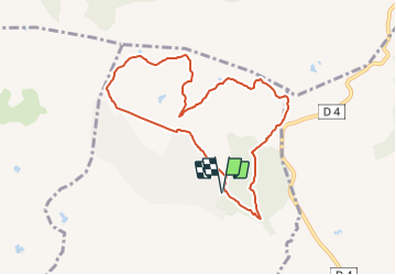
Tour Wandern von 8,7 km verfügbar auf Provence-Alpes-Côte d'Azur, Var, Puget-sur-Argens. Diese Tour wird von fabetfab vorgeschlagen.
Beschreibung
Ballade en boucle, uniquement sur de larges pistes souvent légèrement ombragées qui font découvrir trois petits lacs d'altitude dans le bois du Defens. Parking aisé et coin pique-nique au départ, à l'entrée du Domaine de la Lieutenante.
Ort
Land:
France
Region :
Provence-Alpes-Côte d'Azur
Abteilung/Provinz :
Var
Kommune :
Puget-sur-Argens
Standort:
Unknown
Gehen Sie:(Dec)
Gehen Sie:(UTM)
313709 ; 4818544 (32T) N.
Kommentare
Touren in der Umgebung
![Tour Wandern Puget-sur-Argens - La Lieutenante Anc. Meulière Sce St Martin - Photo](https://media.geolcdn.com/t/375/260/f785d328-8629-4b96-81e2-754ca59456cd.jpg&format=jpg&maxdim=2)
![Wandern Wandern](https://static1.geolcdn.com/sitytour/trail-icons/101.png)
La Lieutenante Anc. Meulière Sce St Martin
Wandern
Sehr leicht
(1)
Puget-sur-Argens,
Provence-Alpes-Côte d'Azur,
Var,
France
![](/images/other/stat-length.png)
11,2 km | 14,2 km-effort
3h 32min
![](https://static1.geolcdn.com/siteimages/upload/files/16400158638029165_repeat_loop_refresh_sync_direction_icon.png)
Ja
![Tour Mountainbike Puget-sur-Argens - Forêt de la Colle du Rouet aux Gorges de Blavet - Fréjus - Photo](https://media.geolcdn.com/t/375/260/ext.jpg?maxdim=2&url=https%3A%2F%2Fservices.sitytrail.com%2FGeolivesWS%2FDownloadMedia.ashx%3FTrailID%3D191635%26Media%3D15278_6.jpg)
![Mountainbike Mountainbike](https://static1.geolcdn.com/sitytour/trail-icons/202.png)
Forêt de la Colle du Rouet aux Gorges de Blavet - Fréjus
Mountainbike
Schwierig
(1)
Puget-sur-Argens,
Provence-Alpes-Côte d'Azur,
Var,
France
![](/images/other/stat-length.png)
23 km | 28 km-effort
3h 0min
![](https://static1.geolcdn.com/siteimages/upload/files/16400158638029165_repeat_loop_refresh_sync_direction_icon.png)
Ja
![Tour Wandern Bagnols-en-Forêt - La Colle du Rouet par le Castel Diaou - Le Muy - Photo](https://media.geolcdn.com/t/375/260/ext.jpg?maxdim=2&url=https%3A%2F%2Fservices.sitytrail.com%2FGeolivesWS%2FDownloadMedia.ashx%3FTrailID%3D191579%26Media%3D15205_3.jpg)
![Wandern Wandern](https://static1.geolcdn.com/sitytour/trail-icons/101.png)
La Colle du Rouet par le Castel Diaou - Le Muy
Wandern
Schwierig
(2)
Bagnols-en-Forêt,
Provence-Alpes-Côte d'Azur,
Var,
France
![](/images/other/stat-length.png)
18,2 km | 27 km-effort
6h 0min
![](https://static1.geolcdn.com/siteimages/upload/files/16400158638029165_repeat_loop_refresh_sync_direction_icon.png)
Ja
![Tour Wandern Fréjus - barage du malpasser - Photo](https://media.geolcdn.com/t/375/260/ext.jpg?maxdim=2&url=https%3A%2F%2Fservices.sitytrail.com%2FGeolivesWS%2FDownloadMedia.ashx%3FTrailID%3D232087%26Media%3Dfix__20131111135300.jpg)
![Wandern Wandern](https://static1.geolcdn.com/sitytour/trail-icons/101.png)
barage du malpasser
Wandern
Sehr leicht
(1)
Fréjus,
Provence-Alpes-Côte d'Azur,
Var,
France
![](/images/other/stat-length.png)
5,1 km | 7,6 km-effort
1h 55min
![](https://static1.geolcdn.com/siteimages/upload/files/16400158638029165_repeat_loop_refresh_sync_direction_icon.png)
Ja
![Tour Zu Fuß Puget-sur-Argens - PUGET SUR ARGENS- gazoduc-Terres Gastes DRI - Photo](https://media.geolcdn.com/t/375/260/ext.jpg?maxdim=2&url=https%3A%2F%2Fstatic1.geolcdn.com%2Fsiteimages%2Fupload%2Ffiles%2F1545311037marcheuse_200dpi.jpg)
![Zu Fuß Zu Fuß](https://static1.geolcdn.com/sitytour/trail-icons/100.png)
PUGET SUR ARGENS- gazoduc-Terres Gastes DRI
Zu Fuß
Einfach
(1)
Puget-sur-Argens,
Provence-Alpes-Côte d'Azur,
Var,
France
![](/images/other/stat-length.png)
7,7 km | 8,9 km-effort
2h 1min
![](https://static1.geolcdn.com/siteimages/upload/files/16400158638029165_repeat_loop_refresh_sync_direction_icon.png)
Ja
![Tour Zu Fuß Bagnols-en-Forêt - BAGNOLS EN FORET- Bois du défens DRI - Photo](https://media.geolcdn.com/t/375/260/ext.jpg?maxdim=2&url=https%3A%2F%2Fstatic1.geolcdn.com%2Fsiteimages%2Fupload%2Ffiles%2F1545311037marcheuse_200dpi.jpg)
![Zu Fuß Zu Fuß](https://static1.geolcdn.com/sitytour/trail-icons/100.png)
BAGNOLS EN FORET- Bois du défens DRI
Zu Fuß
Einfach
(2)
Bagnols-en-Forêt,
Provence-Alpes-Côte d'Azur,
Var,
France
![](/images/other/stat-length.png)
9,3 km | 12,7 km-effort
2h 52min
![](https://static1.geolcdn.com/siteimages/upload/files/16400158638029165_repeat_loop_refresh_sync_direction_icon.png)
Ja
![Tour Wandern Bagnols-en-Forêt - Gorges du Blavet au col de la pierre du coucou - Photo](https://media.geolcdn.com/t/375/260/09e580ef-d921-4dee-80f6-a698afe27096.jpg&format=jpg&maxdim=2)
![Wandern Wandern](https://static1.geolcdn.com/sitytour/trail-icons/101.png)
Gorges du Blavet au col de la pierre du coucou
Wandern
Schwierig
Bagnols-en-Forêt,
Provence-Alpes-Côte d'Azur,
Var,
France
![](/images/other/stat-length.png)
15,8 km | 22 km-effort
4h 44min
![](https://static1.geolcdn.com/siteimages/upload/files/16400158638029165_repeat_loop_refresh_sync_direction_icon.png)
Ja
![Tour sport Bagnols-en-Forêt - Gorges de Blavet pays de Fayence - Photo](https://media.geolcdn.com/t/375/260/752b007a-5919-43b0-bdb0-68a447f575ab.jpg&format=jpg&maxdim=2)
Gorges de Blavet pays de Fayence
sport
Sehr leicht
Bagnols-en-Forêt,
Provence-Alpes-Côte d'Azur,
Var,
France
![](/images/other/stat-length.png)
10,2 km | 16,9 km-effort
Unbekannt
![](https://static1.geolcdn.com/siteimages/upload/files/16400158638029165_repeat_loop_refresh_sync_direction_icon.png)
Ja
![Tour sport Bagnols-en-Forêt - Bagnols en Forêt les meules - Photo](https://media.geolcdn.com/t/375/260/4bb66a92-f34f-4592-9bb4-da4e654f5bf9.jpg&format=jpg&maxdim=2)
Bagnols en Forêt les meules
sport
Sehr leicht
Bagnols-en-Forêt,
Provence-Alpes-Côte d'Azur,
Var,
France
![](/images/other/stat-length.png)
14,3 km | 20 km-effort
Unbekannt
![](https://static1.geolcdn.com/siteimages/upload/files/16400158638029165_repeat_loop_refresh_sync_direction_icon.png)
Ja