![](/images/other/stat-length.png)
![Tour Wandern Vallon-Pont-d'Arc - Ardèche - Photo](https://media.geolcdn.com/t/1900/400/112a2e65-f573-4d7e-91d4-97aa86530fb4.jpg&format=pjpeg&maxdim=2)
Ardèche
francq1976
Benutzer
![Länge](/images/other/stat-length.png)
Länge
7,6 km
![Maximale Höhe](https://static1.geolcdn.com/siteimages/upload/files/1508320355ic_sort_altitude_max_24dp.png)
Maximale Höhe
297 m
![Positive Höhendifferenz](https://static1.geolcdn.com/siteimages/upload/files/1508320355ic_sort_den_pos_24dp.png)
Positive Höhendifferenz
292 m
![Km-Effort](/images/other/stat-length.png)
Km-Effort
11,5 km
![Min. Höhe](https://static1.geolcdn.com/siteimages/upload/files/1508320355ic_sort_altitude_min_24dp.png)
Min. Höhe
83 m
![Negative Höhendifferenz](https://static1.geolcdn.com/siteimages/upload/files/1508320355ic_sort_den_neg_24dp.png)
Negative Höhendifferenz
295 m
![Boucle](https://static1.geolcdn.com/siteimages/upload/files/16400158638029165_repeat_loop_refresh_sync_direction_icon.png)
Boucle
Nein
Erstellungsdatum :
2021-07-20 08:44:33.68
Letzte Änderung :
2021-07-20 12:49:35.85
![Wandern](https://static1.geolcdn.com/sitytour/trail-icons/101.png)
3h06
Schwierigkeit : Schwierig
![Scannen Sie diesen QR-Code, um die Tour in der SityTrail-Anwendung zu öffnen](https://capi.geolives.com/qq0zvz2zws4bq2lad0pu/sitytour/trails/2867746/qr.png?size=200)
Kostenlosegpshiking-Anwendung
Über SityTrail
Tour Wandern von 7,6 km verfügbar auf Auvergne-Rhone-Alpen, Ardèche, Vallon-Pont-d'Arc. Diese Tour wird von francq1976 vorgeschlagen.
Beschreibung
guidance vocale pas au top...dommage de ne pas voir l'arc dans un angle de vue la perçant... néanmoins belle ballade physique en plus!
Ort
Land:
France
Region :
Auvergne-Rhone-Alpen
Abteilung/Provinz :
Ardèche
Kommune :
Vallon-Pont-d'Arc
Standort:
Unknown
Gehen Sie:(Dec)
Gehen Sie:(UTM)
611481 ; 4916755 (31T) N.
Kommentare
Touren in der Umgebung
![Tour Wandern Vallon-Pont-d'Arc - vallon-chastelas - Photo](https://media.geolcdn.com/t/375/260/ext.jpg?maxdim=2&url=https%3A%2F%2Fservices.sitytrail.com%2FGeolivesWS%2FDownloadMedia.ashx%3FTrailID%3D973164%26Media%3D6277a14a-7c60-41f6-8938-7b9c5dd03a0e.jpg)
![Wandern Wandern](https://static1.geolcdn.com/sitytour/trail-icons/101.png)
vallon-chastelas
Wandern
Einfach
(3)
Vallon-Pont-d'Arc,
Auvergne-Rhone-Alpen,
Ardèche,
France
![](/images/other/stat-length.png)
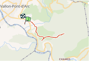
4,5 km | 6,2 km-effort
1h 19min
![](https://static1.geolcdn.com/siteimages/upload/files/16400158638029165_repeat_loop_refresh_sync_direction_icon.png)
Ja
![Tour Wandern Labastide-de-Virac - 07 gorges ardeche - Photo](https://media.geolcdn.com/t/375/260/ext.jpg?maxdim=2&url=https%3A%2F%2Fstatic1.geolcdn.com%2Fsiteimages%2Fupload%2Ffiles%2F1553511878bg_sport_marche.png)
![Wandern Wandern](https://static1.geolcdn.com/sitytour/trail-icons/101.png)
07 gorges ardeche
Wandern
Einfach
(1)
Labastide-de-Virac,
Auvergne-Rhone-Alpen,
Ardèche,
France
![](/images/other/stat-length.png)
13,7 km | 22 km-effort
5h 5min
![](https://static1.geolcdn.com/siteimages/upload/files/16400158638029165_repeat_loop_refresh_sync_direction_icon.png)
Ja
![Tour Wandern Vallon-Pont-d'Arc - 26 grottes deroc Chauvet zel - Photo](https://media.geolcdn.com/t/375/260/7f04590c-50bd-4ffc-b58f-87ccb5055b84.jpg&format=jpg&maxdim=2)
![Wandern Wandern](https://static1.geolcdn.com/sitytour/trail-icons/101.png)
26 grottes deroc Chauvet zel
Wandern
Sehr schwierig
Vallon-Pont-d'Arc,
Auvergne-Rhone-Alpen,
Ardèche,
France
![](/images/other/stat-length.png)
12,3 km | 20 km-effort
4h 39min
![](https://static1.geolcdn.com/siteimages/upload/files/16400158638029165_repeat_loop_refresh_sync_direction_icon.png)
Nein
![Tour Wandern Labastide-de-Virac - les gorges de l'Ardèche - Photo](https://media.geolcdn.com/t/375/260/22a42236-31e2-4521-b8d2-19cd765eb1ce.jpg&format=jpg&maxdim=2)
![Wandern Wandern](https://static1.geolcdn.com/sitytour/trail-icons/101.png)
les gorges de l'Ardèche
Wandern
Medium
Labastide-de-Virac,
Auvergne-Rhone-Alpen,
Ardèche,
France
![](/images/other/stat-length.png)
8,9 km | 14,1 km-effort
5h 14min
![](https://static1.geolcdn.com/siteimages/upload/files/16400158638029165_repeat_loop_refresh_sync_direction_icon.png)
Ja
![Tour Wandern Vallon-Pont-d'Arc - Vallon pont d'arc au bivouac du gournier - Photo](https://media.geolcdn.com/t/375/260/086bf84f-df3e-4a5f-9662-b644951d7f29.jpg&format=jpg&maxdim=2)
![Wandern Wandern](https://static1.geolcdn.com/sitytour/trail-icons/101.png)
Vallon pont d'arc au bivouac du gournier
Wandern
Medium
Vallon-Pont-d'Arc,
Auvergne-Rhone-Alpen,
Ardèche,
France
![](/images/other/stat-length.png)
18,8 km | 31 km-effort
3h 45min
![](https://static1.geolcdn.com/siteimages/upload/files/16400158638029165_repeat_loop_refresh_sync_direction_icon.png)
Nein
![Tour Zu Fuß Lagorce - 07 baravon 05.03.23 - Photo](https://media.geolcdn.com/t/375/260/18100b06-06c3-43e0-8df0-5f11b60408b1.jpg&format=jpg&maxdim=2)
![Zu Fuß Zu Fuß](https://static1.geolcdn.com/sitytour/trail-icons/100.png)
07 baravon 05.03.23
Zu Fuß
Einfach
Lagorce,
Auvergne-Rhone-Alpen,
Ardèche,
France
![](/images/other/stat-length.png)
9,3 km | 14,2 km-effort
3h 13min
![](https://static1.geolcdn.com/siteimages/upload/files/16400158638029165_repeat_loop_refresh_sync_direction_icon.png)
Ja
![Mountainbike Mountainbike](https://static1.geolcdn.com/sitytour/trail-icons/202.png)
Vallon_Pont_d'Arc_20210712_092148
Mountainbike
Sehr leicht
Vallon-Pont-d'Arc,
Auvergne-Rhone-Alpen,
Ardèche,
France
![](/images/other/stat-length.png)
27 km | 34 km-effort
Unbekannt
![](https://static1.geolcdn.com/siteimages/upload/files/16400158638029165_repeat_loop_refresh_sync_direction_icon.png)
Ja
![Tour Wandern Salavas - 07 salavas pont de arc rieussec - Photo](https://media.geolcdn.com/t/375/260/187861b3-f925-444c-bb80-248c619c8cb5.jpg&format=jpg&maxdim=2)
![Wandern Wandern](https://static1.geolcdn.com/sitytour/trail-icons/101.png)
07 salavas pont de arc rieussec
Wandern
Schwierig
Salavas,
Auvergne-Rhone-Alpen,
Ardèche,
France
![](/images/other/stat-length.png)
16,4 km | 23 km-effort
7h 40min
![](https://static1.geolcdn.com/siteimages/upload/files/16400158638029165_repeat_loop_refresh_sync_direction_icon.png)
Ja
![Tour Wandern Vallon-Pont-d'Arc - 07 grotte derocs chauvet - Photo](https://media.geolcdn.com/t/375/260/85789a19-d525-478e-9faa-7a8446c70e43.jpg&format=jpg&maxdim=2)
![Wandern Wandern](https://static1.geolcdn.com/sitytour/trail-icons/101.png)
07 grotte derocs chauvet
Wandern
Schwierig
Vallon-Pont-d'Arc,
Auvergne-Rhone-Alpen,
Ardèche,
France
![](/images/other/stat-length.png)
8,5 km | 14,5 km-effort
6h 18min
![](https://static1.geolcdn.com/siteimages/upload/files/16400158638029165_repeat_loop_refresh_sync_direction_icon.png)
Ja