![](/images/other/stat-length.png)
![Tour Orientierungslauf Glières-Val-de-Borne - exp_16 juil. 2021 à 08-45-33 - Photo](https://media.geolcdn.com/t/1900/400/a0b647e0-bb93-48e0-b524-ce1b6bdde353.jpeg&format=pjpeg&maxdim=2)
exp_16 juil. 2021 à 08-45-33
Myrostates
Benutzer
![Länge](/images/other/stat-length.png)
Länge
14,4 km
![Maximale Höhe](https://static1.geolcdn.com/siteimages/upload/files/1508320355ic_sort_altitude_max_24dp.png)
Maximale Höhe
1726 m
![Positive Höhendifferenz](https://static1.geolcdn.com/siteimages/upload/files/1508320355ic_sort_den_pos_24dp.png)
Positive Höhendifferenz
644 m
![Km-Effort](/images/other/stat-length.png)
Km-Effort
23 km
![Min. Höhe](https://static1.geolcdn.com/siteimages/upload/files/1508320355ic_sort_altitude_min_24dp.png)
Min. Höhe
1361 m
![Negative Höhendifferenz](https://static1.geolcdn.com/siteimages/upload/files/1508320355ic_sort_den_neg_24dp.png)
Negative Höhendifferenz
641 m
![Boucle](https://static1.geolcdn.com/siteimages/upload/files/16400158638029165_repeat_loop_refresh_sync_direction_icon.png)
Boucle
Ja
Erstellungsdatum :
2021-07-18 14:56:00.0
Letzte Änderung :
2021-07-18 15:46:45.508
![Orientierungslauf](https://static1.geolcdn.com/sitytour/trail-icons/906.png)
5h30
Schwierigkeit : Medium
![Scannen Sie diesen QR-Code, um die Tour in der SityTrail-Anwendung zu öffnen](https://capi.geolives.com/qq0zvz2zws4bq2lad0pu/sitytour/trails/2865554/qr.png?size=200)
Kostenlosegpshiking-Anwendung
Über SityTrail
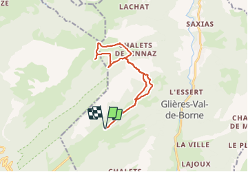
Tour Orientierungslauf von 14,4 km verfügbar auf Auvergne-Rhone-Alpen, Hochsavoyen, Glières-Val-de-Borne. Diese Tour wird von Myrostates vorgeschlagen.
Beschreibung
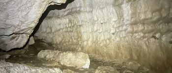
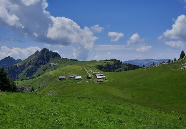
Entrainement Cartographie en partant du Plateau des Glières, en passant par Champs Laitier et le Col du Cable, avec en guise de cerise sur gateau, le passage dans la Grotte du Col du Cable.
Ort
Land:
France
Region :
Auvergne-Rhone-Alpen
Abteilung/Provinz :
Hochsavoyen
Kommune :
Glières-Val-de-Borne
Standort:
Le Petit-Bornand-les-Glières
Gehen Sie:(Dec)
Gehen Sie:(UTM)
294710 ; 5094823 (32T) N.
Kommentare
Touren in der Umgebung
![Tour Wandern Fillière - 12-06-2022 Col de l'Enclave - Photo](https://media.geolcdn.com/t/375/260/d6de4e1d-df10-43ee-a034-704376f533a0.jpg&format=jpg&maxdim=2)
![Wandern Wandern](https://static1.geolcdn.com/sitytour/trail-icons/101.png)
12-06-2022 Col de l'Enclave
Wandern
Medium
Fillière,
Auvergne-Rhone-Alpen,
Hochsavoyen,
France
![](/images/other/stat-length.png)
11,8 km | 24 km-effort
3h 42min
![](https://static1.geolcdn.com/siteimages/upload/files/16400158638029165_repeat_loop_refresh_sync_direction_icon.png)
Ja
![Tour Wandern Fillière - tête de l'Apertaz, tête ronde et tête noire - Photo](https://media.geolcdn.com/t/375/260/9358e43f-1fd9-4d2d-9709-2c010ae10748.jpg&format=jpg&maxdim=2)
![Wandern Wandern](https://static1.geolcdn.com/sitytour/trail-icons/101.png)
tête de l'Apertaz, tête ronde et tête noire
Wandern
Medium
Fillière,
Auvergne-Rhone-Alpen,
Hochsavoyen,
France
![](/images/other/stat-length.png)
12,6 km | 21 km-effort
5h 55min
![](https://static1.geolcdn.com/siteimages/upload/files/16400158638029165_repeat_loop_refresh_sync_direction_icon.png)
Ja
![Tour Wandern Fillière - GLIERES: MONUMENT - CHALETS DES AUGES - GAUTARD - Photo](https://media.geolcdn.com/t/375/260/ext.jpg?maxdim=2&url=https%3A%2F%2Fstatic1.geolcdn.com%2Fsiteimages%2Fupload%2Ffiles%2F1553511878bg_sport_marche.png)
![Wandern Wandern](https://static1.geolcdn.com/sitytour/trail-icons/101.png)
GLIERES: MONUMENT - CHALETS DES AUGES - GAUTARD
Wandern
Einfach
(1)
Fillière,
Auvergne-Rhone-Alpen,
Hochsavoyen,
France
![](/images/other/stat-length.png)
8,8 km | 14,5 km-effort
3h 0min
![](https://static1.geolcdn.com/siteimages/upload/files/16400158638029165_repeat_loop_refresh_sync_direction_icon.png)
Nein
![Tour Wandern Fillière - Les Molliets-Pertuis-Ablon 10 Mai 2018 - Photo](https://media.geolcdn.com/t/375/260/ext.jpg?maxdim=2&url=https%3A%2F%2Fservices.sitytrail.com%2FGeolivesWS%2FDownloadMedia.ashx%3FTrailID%3D963611%26Media%3Dfix__20180511153838.jpg)
![Wandern Wandern](https://static1.geolcdn.com/sitytour/trail-icons/101.png)
Les Molliets-Pertuis-Ablon 10 Mai 2018
Wandern
Schwierig
Fillière,
Auvergne-Rhone-Alpen,
Hochsavoyen,
France
![](/images/other/stat-length.png)
18,2 km | 32 km-effort
7h 6min
![](https://static1.geolcdn.com/siteimages/upload/files/16400158638029165_repeat_loop_refresh_sync_direction_icon.png)
Ja
![Tour Wandern Fillière - 20170806115426 90167 data - Photo](https://media.geolcdn.com/t/375/260/ext.jpg?maxdim=2&url=https%3A%2F%2Fstatic1.geolcdn.com%2Fsiteimages%2Fupload%2Ffiles%2F1553511878bg_sport_marche.png)
![Wandern Wandern](https://static1.geolcdn.com/sitytour/trail-icons/101.png)
20170806115426 90167 data
Wandern
Einfach
(1)
Fillière,
Auvergne-Rhone-Alpen,
Hochsavoyen,
France
![](/images/other/stat-length.png)
3,2 km | 8,6 km-effort
1h 53min
![](https://static1.geolcdn.com/siteimages/upload/files/16400158638029165_repeat_loop_refresh_sync_direction_icon.png)
Nein
![Tour Wandern Glières-Val-de-Borne - Refuge de Spé - Photo](https://media.geolcdn.com/t/375/260/ext.jpg?maxdim=2&url=https%3A%2F%2Fstatic1.geolcdn.com%2Fsiteimages%2Fupload%2Ffiles%2F1553511878bg_sport_marche.png)
![Wandern Wandern](https://static1.geolcdn.com/sitytour/trail-icons/101.png)
Refuge de Spé
Wandern
Sehr leicht
(1)
Glières-Val-de-Borne,
Auvergne-Rhone-Alpen,
Hochsavoyen,
France
![](/images/other/stat-length.png)
3,7 km | 5 km-effort
Unbekannt
![](https://static1.geolcdn.com/siteimages/upload/files/16400158638029165_repeat_loop_refresh_sync_direction_icon.png)
Nein
![Tour Wandern Fillière - Chalets des Auges - Photo](https://media.geolcdn.com/t/375/260/7d7a617b-facc-459b-b993-7b97aa275494.jpg&format=jpg&maxdim=2)
![Wandern Wandern](https://static1.geolcdn.com/sitytour/trail-icons/101.png)
Chalets des Auges
Wandern
Sehr schwierig
Fillière,
Auvergne-Rhone-Alpen,
Hochsavoyen,
France
![](/images/other/stat-length.png)
12,2 km | 19,2 km-effort
4h 21min
![](https://static1.geolcdn.com/siteimages/upload/files/16400158638029165_repeat_loop_refresh_sync_direction_icon.png)
Ja
![Tour Wandern Fillière - SOUS DINE PAR LE PAS DU ROC - Photo](https://media.geolcdn.com/t/375/260/4f7b0ce3-ccee-450a-b2cd-4c3481f6f318.jpg&format=jpg&maxdim=2)
![Wandern Wandern](https://static1.geolcdn.com/sitytour/trail-icons/101.png)
SOUS DINE PAR LE PAS DU ROC
Wandern
Schwierig
Fillière,
Auvergne-Rhone-Alpen,
Hochsavoyen,
France
![](/images/other/stat-length.png)
18,2 km | 34 km-effort
7h 44min
![](https://static1.geolcdn.com/siteimages/upload/files/16400158638029165_repeat_loop_refresh_sync_direction_icon.png)
Ja
![Tour Wandern Glières-Val-de-Borne - GLIERES: TOUR DE LA MONTAGNE DES FRETES mai 2023 - Photo](https://media.geolcdn.com/t/375/260/7effa61e-f263-4a8f-86ae-6b39e4d6eab9.jpg&format=jpg&maxdim=2)
![Wandern Wandern](https://static1.geolcdn.com/sitytour/trail-icons/101.png)
GLIERES: TOUR DE LA MONTAGNE DES FRETES mai 2023
Wandern
Schwierig
Glières-Val-de-Borne,
Auvergne-Rhone-Alpen,
Hochsavoyen,
France
![](/images/other/stat-length.png)
16,6 km | 26 km-effort
6h 30min
![](https://static1.geolcdn.com/siteimages/upload/files/16400158638029165_repeat_loop_refresh_sync_direction_icon.png)
Ja