![](/images/other/stat-length.png)
![Tour Léoncel - 2021-07-15_18h15m10_Cirkwi-Forêt_de_Comblezine - Photo](https://media.geolcdn.com/t/1900/400/ext.pjpeg?maxdim=2&url=https%3A%2F%2Fsecurestorage.geolives.com%2Fsitytour%2Ftrail-bg%2Fdefault.jpg)
2021-07-15_18h15m10_Cirkwi-Forêt_de_Comblezine
michar
Benutzer
![Länge](/images/other/stat-length.png)
Länge
8,7 km
![Maximale Höhe](https://static1.geolcdn.com/siteimages/upload/files/1508320355ic_sort_altitude_max_24dp.png)
Maximale Höhe
1340 m
![Positive Höhendifferenz](https://static1.geolcdn.com/siteimages/upload/files/1508320355ic_sort_den_pos_24dp.png)
Positive Höhendifferenz
236 m
![Km-Effort](/images/other/stat-length.png)
Km-Effort
11,8 km
![Min. Höhe](https://static1.geolcdn.com/siteimages/upload/files/1508320355ic_sort_altitude_min_24dp.png)
Min. Höhe
1153 m
![Negative Höhendifferenz](https://static1.geolcdn.com/siteimages/upload/files/1508320355ic_sort_den_neg_24dp.png)
Negative Höhendifferenz
240 m
![Boucle](https://static1.geolcdn.com/siteimages/upload/files/16400158638029165_repeat_loop_refresh_sync_direction_icon.png)
Boucle
Ja
Erstellungsdatum :
2021-07-15 16:15:10.227
Letzte Änderung :
2021-07-15 16:15:15.614
![Scannen Sie diesen QR-Code, um die Tour in der SityTrail-Anwendung zu öffnen](https://capi.geolives.com/qq0zvz2zws4bq2lad0pu/sitytour/trails/2861907/qr.png?size=200)
Kostenlosegpshiking-Anwendung
Über SityTrail
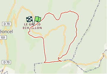
Tour von 8,7 km verfügbar auf Auvergne-Rhone-Alpen, Drôme, Léoncel. Diese Tour wird von michar vorgeschlagen.
Beschreibung
Randonnée forestière sur le domaine du Grand Echaillon. L'itinéraire reste principalement en forêt et permet une belle découverte de ce milieu où de nombreuses essences végétales se côtoient.
Ort
Land:
France
Region :
Auvergne-Rhone-Alpen
Abteilung/Provinz :
Drôme
Kommune :
Léoncel
Standort:
Unknown
Gehen Sie:(Dec)
Gehen Sie:(UTM)
674358 ; 4975733 (31T) N.
Kommentare
Touren in der Umgebung
![Tour Wandern Omblèze - 2021-07-26_17h20m33_1627312809705_Plateau d_Ambel 15km.gpx.xml - Photo](https://media.geolcdn.com/t/375/260/07e91571-7633-48aa-a91e-19fa46a2d0cc.jpg&format=jpg&maxdim=2)
![Wandern Wandern](https://static1.geolcdn.com/sitytour/trail-icons/101.png)
2021-07-26_17h20m33_1627312809705_Plateau d_Ambel 15km.gpx.xml
Wandern
Sehr schwierig
(1)
Omblèze,
Auvergne-Rhone-Alpen,
Drôme,
France
![](/images/other/stat-length.png)
14,9 km | 22 km-effort
4h 56min
![](https://static1.geolcdn.com/siteimages/upload/files/16400158638029165_repeat_loop_refresh_sync_direction_icon.png)
Ja
![Tour Wandern Le Chaffal - 26 vacherie arches comberoufle - Photo](https://media.geolcdn.com/t/375/260/27ca79a9-2463-4a38-9d47-59fa4758352c.jpg&format=jpg&maxdim=2)
![Wandern Wandern](https://static1.geolcdn.com/sitytour/trail-icons/101.png)
26 vacherie arches comberoufle
Wandern
Einfach
Le Chaffal,
Auvergne-Rhone-Alpen,
Drôme,
France
![](/images/other/stat-length.png)
7,3 km | 12,1 km-effort
3h 25min
![](https://static1.geolcdn.com/siteimages/upload/files/16400158638029165_repeat_loop_refresh_sync_direction_icon.png)
Ja
![Tour Wandern Bouvante - 26 bouvante pas ligue st truite - Photo](https://media.geolcdn.com/t/375/260/9494233e-7248-475d-add1-20018e6bbb97.jpg&format=jpg&maxdim=2)
![Wandern Wandern](https://static1.geolcdn.com/sitytour/trail-icons/101.png)
26 bouvante pas ligue st truite
Wandern
Schwierig
Bouvante,
Auvergne-Rhone-Alpen,
Drôme,
France
![](/images/other/stat-length.png)
18,7 km | 31 km-effort
8h 42min
![](https://static1.geolcdn.com/siteimages/upload/files/16400158638029165_repeat_loop_refresh_sync_direction_icon.png)
Nein
![Tour Wandern Omblèze - 26 pas de la sausse - Photo](https://media.geolcdn.com/t/375/260/ext.jpg?maxdim=2&url=https%3A%2F%2Fservices.sitytrail.com%2FGeolivesWS%2FDownloadMedia.ashx%3FTrailID%3D472646%26Media%3Dfix__20140403141012.jpg)
![Wandern Wandern](https://static1.geolcdn.com/sitytour/trail-icons/101.png)
26 pas de la sausse
Wandern
Medium
Omblèze,
Auvergne-Rhone-Alpen,
Drôme,
France
![](/images/other/stat-length.png)
12,2 km | 22 km-effort
4h 56min
![](https://static1.geolcdn.com/siteimages/upload/files/16400158638029165_repeat_loop_refresh_sync_direction_icon.png)
Nein
![Tour Wandern Léoncel - les roches de treillaras - Photo](https://media.geolcdn.com/t/375/260/ext.jpg?maxdim=2&url=https%3A%2F%2Fstatic1.geolcdn.com%2Fsiteimages%2Fupload%2Ffiles%2F1553511878bg_sport_marche.png)
![Wandern Wandern](https://static1.geolcdn.com/sitytour/trail-icons/101.png)
les roches de treillaras
Wandern
Einfach
(3)
Léoncel,
Auvergne-Rhone-Alpen,
Drôme,
France
![](/images/other/stat-length.png)
11 km | 16 km-effort
2h 14min
![](https://static1.geolcdn.com/siteimages/upload/files/16400158638029165_repeat_loop_refresh_sync_direction_icon.png)
Nein
![Tour Wandern Léoncel - Rando Pas du touet -rocher de la drayette - Photo](https://media.geolcdn.com/t/375/260/ext.jpg?maxdim=2&url=https%3A%2F%2Fstatic1.geolcdn.com%2Fsiteimages%2Fupload%2Ffiles%2F1553511878bg_sport_marche.png)
![Wandern Wandern](https://static1.geolcdn.com/sitytour/trail-icons/101.png)
Rando Pas du touet -rocher de la drayette
Wandern
Einfach
(3)
Léoncel,
Auvergne-Rhone-Alpen,
Drôme,
France
![](/images/other/stat-length.png)
6,3 km | 8,8 km-effort
2h 11min
![](https://static1.geolcdn.com/siteimages/upload/files/16400158638029165_repeat_loop_refresh_sync_direction_icon.png)
Ja
![Tour Wandern Léoncel - Pierre Chauve depuis le Col de Tourniol - Photo](https://media.geolcdn.com/t/375/260/ext.jpg?maxdim=2&url=https%3A%2F%2Fstatic1.geolcdn.com%2Fsiteimages%2Fupload%2Ffiles%2F1553511878bg_sport_marche.png)
![Wandern Wandern](https://static1.geolcdn.com/sitytour/trail-icons/101.png)
Pierre Chauve depuis le Col de Tourniol
Wandern
Einfach
(3)
Léoncel,
Auvergne-Rhone-Alpen,
Drôme,
France
![](/images/other/stat-length.png)
7,9 km | 12,3 km-effort
2h 52min
![](https://static1.geolcdn.com/siteimages/upload/files/16400158638029165_repeat_loop_refresh_sync_direction_icon.png)
Ja
![Tour Mountainbike Léoncel - Tête de la Dame - Photo](https://media.geolcdn.com/t/375/260/ext.jpg?maxdim=2&url=https%3A%2F%2Fstatic1.geolcdn.com%2Fsiteimages%2Fupload%2Ffiles%2F1524743154velo.jpg)
![Mountainbike Mountainbike](https://static1.geolcdn.com/sitytour/trail-icons/202.png)
Tête de la Dame
Mountainbike
Medium
(1)
Léoncel,
Auvergne-Rhone-Alpen,
Drôme,
France
![](/images/other/stat-length.png)
27 km | 39 km-effort
2h 35min
![](https://static1.geolcdn.com/siteimages/upload/files/16400158638029165_repeat_loop_refresh_sync_direction_icon.png)
Ja
![Tour Wandern Barbières - 26 pierre chauve barbieres zel - Photo](https://media.geolcdn.com/t/375/260/92caf138-cce3-4645-835e-f3491e5ff577.jpg&format=jpg&maxdim=2)
![Wandern Wandern](https://static1.geolcdn.com/sitytour/trail-icons/101.png)
26 pierre chauve barbieres zel
Wandern
Medium
Barbières,
Auvergne-Rhone-Alpen,
Drôme,
France
![](/images/other/stat-length.png)
13,8 km | 26 km-effort
7h 9min
![](https://static1.geolcdn.com/siteimages/upload/files/16400158638029165_repeat_loop_refresh_sync_direction_icon.png)
Nein