![](/images/other/stat-length.png)
![Tour Radtourismus Pineuilh - 008 Ste Foy to La Réole - Photo](https://media.geolcdn.com/t/1900/400/ext.pjpeg?maxdim=2&url=https%3A%2F%2Fstatic1.geolcdn.com%2Fsiteimages%2Fupload%2Ffiles%2F1524743154velo.jpg)
008 Ste Foy to La Réole
Piper.Classique
Benutzer
![Länge](/images/other/stat-length.png)
Länge
48 km
![Maximale Höhe](https://static1.geolcdn.com/siteimages/upload/files/1508320355ic_sort_altitude_max_24dp.png)
Maximale Höhe
121 m
![Positive Höhendifferenz](https://static1.geolcdn.com/siteimages/upload/files/1508320355ic_sort_den_pos_24dp.png)
Positive Höhendifferenz
666 m
![Km-Effort](/images/other/stat-length.png)
Km-Effort
57 km
![Min. Höhe](https://static1.geolcdn.com/siteimages/upload/files/1508320355ic_sort_altitude_min_24dp.png)
Min. Höhe
10 m
![Negative Höhendifferenz](https://static1.geolcdn.com/siteimages/upload/files/1508320355ic_sort_den_neg_24dp.png)
Negative Höhendifferenz
669 m
![Boucle](https://static1.geolcdn.com/siteimages/upload/files/16400158638029165_repeat_loop_refresh_sync_direction_icon.png)
Boucle
Nein
Erstellungsdatum :
2021-07-13 09:42:03.549
Letzte Änderung :
2021-07-15 15:52:43.202
![Radtourismus](https://static1.geolcdn.com/sitytour/trail-icons/204.png)
--
Schwierigkeit : Unbekannt
![Scannen Sie diesen QR-Code, um die Tour in der SityTrail-Anwendung zu öffnen](https://capi.geolives.com/qq0zvz2zws4bq2lad0pu/sitytour/trails/2859278/qr.png?size=200)
Kostenlosegpshiking-Anwendung
Über SityTrail
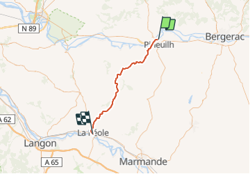
Tour Radtourismus von 48 km verfügbar auf Neu-Aquitanien, Gironde, Pineuilh. Diese Tour wird von Piper.Classique vorgeschlagen.
Beschreibung
There is some gravel shortly after Coutures. You can avoid this by continuing on the D15 to the next major crossroads then turning left onto the D126E3
Ort
Land:
France
Region :
Neu-Aquitanien
Abteilung/Provinz :
Gironde
Kommune :
Pineuilh
Standort:
Unknown
Gehen Sie:(Dec)
Gehen Sie:(UTM)
280668 ; 4969383 (31T) N.
Kommentare
Touren in der Umgebung
![Tour Zu Fuß Le Fleix - Boucle de Gabastou - Photo](https://media.geolcdn.com/t/375/260/18d814c7-f45f-471d-9961-e2b02014db18.jpeg&format=jpg&maxdim=2)
![Zu Fuß Zu Fuß](https://static1.geolcdn.com/sitytour/trail-icons/100.png)
Boucle de Gabastou
Zu Fuß
Einfach
Le Fleix,
Neu-Aquitanien,
Dordogne,
France
![](/images/other/stat-length.png)
8,4 km | 10 km-effort
2h 16min
![](https://static1.geolcdn.com/siteimages/upload/files/16400158638029165_repeat_loop_refresh_sync_direction_icon.png)
Nein
![Tour Zu Fuß Le Fleix - Boucle de Cap de fer - Photo](https://media.geolcdn.com/t/375/260/86475a03-e544-4a11-b09f-95948087b74f.jpeg&format=jpg&maxdim=2)
![Zu Fuß Zu Fuß](https://static1.geolcdn.com/sitytour/trail-icons/100.png)
Boucle de Cap de fer
Zu Fuß
Einfach
Le Fleix,
Neu-Aquitanien,
Dordogne,
France
![](/images/other/stat-length.png)
5,7 km | 7,7 km-effort
1h 45min
![](https://static1.geolcdn.com/siteimages/upload/files/16400158638029165_repeat_loop_refresh_sync_direction_icon.png)
Nein
![Tour Wandern Le Fleix - le sac, les cèdres, st avit - Photo](https://media.geolcdn.com/t/375/260/ext.jpg?maxdim=2&url=https%3A%2F%2Fstatic1.geolcdn.com%2Fsiteimages%2Fupload%2Ffiles%2F1553511878bg_sport_marche.png)
![Wandern Wandern](https://static1.geolcdn.com/sitytour/trail-icons/101.png)
le sac, les cèdres, st avit
Wandern
Einfach
Le Fleix,
Neu-Aquitanien,
Dordogne,
France
![](/images/other/stat-length.png)
10,4 km | 11,3 km-effort
3h 30min
![](https://static1.geolcdn.com/siteimages/upload/files/16400158638029165_repeat_loop_refresh_sync_direction_icon.png)
Ja
![Tour Mountainbike Pineuilh - 9 Sainte Foy la Grande-Bazas-St Jacques de Compostelle - Photo](https://media.geolcdn.com/t/375/260/ext.jpg?maxdim=2&url=https%3A%2F%2Fstatic1.geolcdn.com%2Fsiteimages%2Fupload%2Ffiles%2F1524743154velo.jpg)
![Mountainbike Mountainbike](https://static1.geolcdn.com/sitytour/trail-icons/202.png)
9 Sainte Foy la Grande-Bazas-St Jacques de Compostelle
Mountainbike
Schwierig
Pineuilh,
Neu-Aquitanien,
Gironde,
France
![](/images/other/stat-length.png)
99 km | 119 km-effort
7h 38min
![](https://static1.geolcdn.com/siteimages/upload/files/16400158638029165_repeat_loop_refresh_sync_direction_icon.png)
Nein
![Tour Wandern Le Fleix - moulins et rivière - Photo](https://media.geolcdn.com/t/375/260/ext.jpg?maxdim=2&url=https%3A%2F%2Fstatic1.geolcdn.com%2Fsiteimages%2Fupload%2Ffiles%2F1553511878bg_sport_marche.png)
![Wandern Wandern](https://static1.geolcdn.com/sitytour/trail-icons/101.png)
moulins et rivière
Wandern
Medium
Le Fleix,
Neu-Aquitanien,
Dordogne,
France
![](/images/other/stat-length.png)
13,1 km | 16 km-effort
6h 0min
![](https://static1.geolcdn.com/siteimages/upload/files/16400158638029165_repeat_loop_refresh_sync_direction_icon.png)
Ja
![Tour Wandern Le Fleix - Puy Servain - Photo](https://media.geolcdn.com/t/375/260/ext.jpg?maxdim=2&url=https%3A%2F%2Fstatic1.geolcdn.com%2Fsiteimages%2Fupload%2Ffiles%2F1553511878bg_sport_marche.png)
![Wandern Wandern](https://static1.geolcdn.com/sitytour/trail-icons/101.png)
Puy Servain
Wandern
Medium
Le Fleix,
Neu-Aquitanien,
Dordogne,
France
![](/images/other/stat-length.png)
13,1 km | 16 km-effort
6h 0min
![](https://static1.geolcdn.com/siteimages/upload/files/16400158638029165_repeat_loop_refresh_sync_direction_icon.png)
Ja
![Tour Wandern Le Fleix - la joubine - Photo](https://media.geolcdn.com/t/375/260/ext.jpg?maxdim=2&url=https%3A%2F%2Fstatic1.geolcdn.com%2Fsiteimages%2Fupload%2Ffiles%2F1553511878bg_sport_marche.png)
![Wandern Wandern](https://static1.geolcdn.com/sitytour/trail-icons/101.png)
la joubine
Wandern
Einfach
Le Fleix,
Neu-Aquitanien,
Dordogne,
France
![](/images/other/stat-length.png)
18,5 km | 22 km-effort
5h 24min
![](https://static1.geolcdn.com/siteimages/upload/files/16400158638029165_repeat_loop_refresh_sync_direction_icon.png)
Ja
![Tour Laufen Le Fleix - Le Fleix - Trail 39km - Photo](https://media.geolcdn.com/t/375/260/ext.jpg?maxdim=2&url=https%3A%2F%2Fstatic1.geolcdn.com%2Fsiteimages%2Fupload%2Ffiles%2F1524743154running.jpg)
![Laufen Laufen](https://static1.geolcdn.com/sitytour/trail-icons/103.png)
Le Fleix - Trail 39km
Laufen
Schwierig
Le Fleix,
Neu-Aquitanien,
Dordogne,
France
![](/images/other/stat-length.png)
39 km | 47 km-effort
4h 30min
![](https://static1.geolcdn.com/siteimages/upload/files/16400158638029165_repeat_loop_refresh_sync_direction_icon.png)
Ja
![Tour Mountainbike Le Fleix - Le Fleix - Trail 39km - Photo](https://media.geolcdn.com/t/375/260/ext.jpg?maxdim=2&url=https%3A%2F%2Fstatic1.geolcdn.com%2Fsiteimages%2Fupload%2Ffiles%2F1524743154velo.jpg)
![Mountainbike Mountainbike](https://static1.geolcdn.com/sitytour/trail-icons/202.png)
Le Fleix - Trail 39km
Mountainbike
Medium
Le Fleix,
Neu-Aquitanien,
Dordogne,
France
![](/images/other/stat-length.png)
39 km | 47 km-effort
2h 30min
![](https://static1.geolcdn.com/siteimages/upload/files/16400158638029165_repeat_loop_refresh_sync_direction_icon.png)
Ja