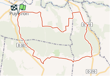
![](/images/other/stat-length.png)
![Tour Mountainbike Puygiron - PIERRE ROUSSE-Puygiron - Photo](https://media.geolcdn.com/t/1900/400/ext.pjpeg?maxdim=2&url=https%3A%2F%2Fstatic1.geolcdn.com%2Fsiteimages%2Fupload%2Ffiles%2F1524743154velo.jpg)
PIERRE ROUSSE-Puygiron
charlytan
Benutzer
![Länge](/images/other/stat-length.png)
Länge
12,4 km
![Maximale Höhe](https://static1.geolcdn.com/siteimages/upload/files/1508320355ic_sort_altitude_max_24dp.png)
Maximale Höhe
265 m
![Positive Höhendifferenz](https://static1.geolcdn.com/siteimages/upload/files/1508320355ic_sort_den_pos_24dp.png)
Positive Höhendifferenz
236 m
![Km-Effort](/images/other/stat-length.png)
Km-Effort
15,5 km
![Min. Höhe](https://static1.geolcdn.com/siteimages/upload/files/1508320355ic_sort_altitude_min_24dp.png)
Min. Höhe
149 m
![Negative Höhendifferenz](https://static1.geolcdn.com/siteimages/upload/files/1508320355ic_sort_den_neg_24dp.png)
Negative Höhendifferenz
238 m
![Boucle](https://static1.geolcdn.com/siteimages/upload/files/16400158638029165_repeat_loop_refresh_sync_direction_icon.png)
Boucle
Ja
Erstellungsdatum :
2021-07-08 14:04:26.317
Letzte Änderung :
2021-08-20 12:01:27.262
![Mountainbike](https://static1.geolcdn.com/sitytour/trail-icons/202.png)
--
Schwierigkeit : Unbekannt
![Scannen Sie diesen QR-Code, um die Tour in der SityTrail-Anwendung zu öffnen](https://capi.geolives.com/qq0zvz2zws4bq2lad0pu/sitytour/trails/2853921/qr.png?size=200)
Kostenlosegpshiking-Anwendung
Über SityTrail
Tour Mountainbike von 12,4 km verfügbar auf Auvergne-Rhone-Alpen, Drôme, Puygiron. Diese Tour wird von charlytan vorgeschlagen.
Beschreibung
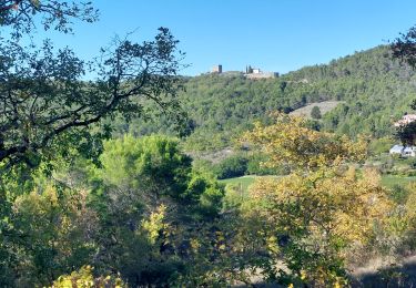
Commencez ce circuit au coeur de Puygiron où est niché un château du XIIe siècle classé. Un belvédère de choix, surplombant la plaine de la Valdaine et les anciennes ruelles du village. Poursuivez par de petits sentiers en forêts, ombragés et paisibles.
Ort
Land:
France
Region :
Auvergne-Rhone-Alpen
Abteilung/Provinz :
Drôme
Kommune :
Puygiron
Standort:
Unknown
Gehen Sie:(Dec)
Gehen Sie:(UTM)
646809 ; 4933800 (31T) N.
Kommentare
Touren in der Umgebung
![Tour Wandern Portes-en-Valdaine - GPX-Rando-Plaine-Portoise-nouvelleversion - Photo](https://media.geolcdn.com/t/375/260/ext.jpg?maxdim=2&url=https%3A%2F%2Fmedia.geolcdn.com%2Ff%2F521ae53d-ced6-46fa-9655-4eb3952c25ee.jpg)
![Wandern Wandern](https://static1.geolcdn.com/sitytour/trail-icons/101.png)
GPX-Rando-Plaine-Portoise-nouvelleversion
Wandern
Einfach
(1)
Portes-en-Valdaine,
Auvergne-Rhone-Alpen,
Drôme,
France
![](/images/other/stat-length.png)
7,1 km | 8,2 km-effort
2h 0min
![](https://static1.geolcdn.com/siteimages/upload/files/16400158638029165_repeat_loop_refresh_sync_direction_icon.png)
Ja
![Tour Wandern Allan - allan transclavienne rac - Photo](https://media.geolcdn.com/t/375/260/ext.jpg?maxdim=2&url=https%3A%2F%2Fservices.sitytrail.com%2FGeolivesWS%2FDownloadMedia.ashx%3FTrailID%3D649381%26Media%3Dfix__20161022171755.jpg)
![Wandern Wandern](https://static1.geolcdn.com/sitytour/trail-icons/101.png)
allan transclavienne rac
Wandern
Sehr leicht
(1)
Allan,
Auvergne-Rhone-Alpen,
Drôme,
France
![](/images/other/stat-length.png)
19,1 km | 26 km-effort
5h 11min
![](https://static1.geolcdn.com/siteimages/upload/files/16400158638029165_repeat_loop_refresh_sync_direction_icon.png)
Ja
![Tour Mountainbike Puygiron - Puygiron VTT n°5 - Photo](https://media.geolcdn.com/t/375/260/ext.jpg?maxdim=2&url=https%3A%2F%2Fservices.sitytrail.com%2FGeolivesWS%2FDownloadMedia.ashx%3FTrailID%3D104845%26Media%3D8346_2.jpg)
![Mountainbike Mountainbike](https://static1.geolcdn.com/sitytour/trail-icons/202.png)
Puygiron VTT n°5
Mountainbike
Sehr schwierig
(1)
Puygiron,
Auvergne-Rhone-Alpen,
Drôme,
France
![](/images/other/stat-length.png)
47 km | 60 km-effort
3h 0min
![](https://static1.geolcdn.com/siteimages/upload/files/16400158638029165_repeat_loop_refresh_sync_direction_icon.png)
Ja
![Tour Wandern La Touche - La Touche Crêtes de l'ysard 12km. - Photo](https://media.geolcdn.com/t/375/260/ext.jpg?maxdim=2&url=https%3A%2F%2Fmedia.geolcdn.com%2Ff%2Fb7717e93-9def-4e5d-8328-3e96528d5925.jpg)
![Wandern Wandern](https://static1.geolcdn.com/sitytour/trail-icons/101.png)
La Touche Crêtes de l'ysard 12km.
Wandern
Schwierig
(1)
La Touche,
Auvergne-Rhone-Alpen,
Drôme,
France
![](/images/other/stat-length.png)
12,1 km | 16,8 km-effort
3h 48min
![](https://static1.geolcdn.com/siteimages/upload/files/16400158638029165_repeat_loop_refresh_sync_direction_icon.png)
Ja
![Tour Wandern La Touche - Citelles hameau et ruisseaux 10km - Photo](https://media.geolcdn.com/t/375/260/ext.jpg?maxdim=2&url=https%3A%2F%2Fmedia.geolcdn.com%2Ff%2Fae07cd43-efe5-443c-ada6-328c965bd163.jpg)
![Wandern Wandern](https://static1.geolcdn.com/sitytour/trail-icons/101.png)
Citelles hameau et ruisseaux 10km
Wandern
Einfach
(2)
La Touche,
Auvergne-Rhone-Alpen,
Drôme,
France
![](/images/other/stat-length.png)
9,6 km | 12,6 km-effort
3h 7min
![](https://static1.geolcdn.com/siteimages/upload/files/16400158638029165_repeat_loop_refresh_sync_direction_icon.png)
Ja
![Tour sport Allan - SityTrail - Les Villages Perchés. - Photo](https://media.geolcdn.com/t/375/260/ext.jpg?maxdim=2&url=https%3A%2F%2Fsecurestorage.geolives.com%2Fsitytour%2Ftrail-bg%2Fdefault.jpg)
SityTrail - Les Villages Perchés.
sport
Sehr leicht
(1)
Allan,
Auvergne-Rhone-Alpen,
Drôme,
France
![](/images/other/stat-length.png)
19,5 km | 27 km-effort
Unbekannt
![](https://static1.geolcdn.com/siteimages/upload/files/16400158638029165_repeat_loop_refresh_sync_direction_icon.png)
Ja
![Tour Wandern Montboucher-sur-Jabron - 20240428 Rando vieux - Photo](https://media.geolcdn.com/t/375/260/ext.jpg?maxdim=2&url=https%3A%2F%2Fmedia.geolcdn.com%2Ff%2F67a1a66e-fe13-4f22-824f-d979f0166131.jpg)
![Wandern Wandern](https://static1.geolcdn.com/sitytour/trail-icons/101.png)
20240428 Rando vieux
Wandern
Sehr leicht
Montboucher-sur-Jabron,
Auvergne-Rhone-Alpen,
Drôme,
France
![](/images/other/stat-length.png)
6,1 km | 6,5 km-effort
5h 17min
![](https://static1.geolcdn.com/siteimages/upload/files/16400158638029165_repeat_loop_refresh_sync_direction_icon.png)
Ja
![Tour Wandern Rochefort-en-Valdaine - tmpWriteApidae_267713_fr - Photo](https://media.geolcdn.com/t/375/260/ext.jpg?maxdim=2&url=https%3A%2F%2Fmedia.geolcdn.com%2Ff%2Fbf0d88ed-89ea-4be9-80b3-1d1069ea4a69.jpg)
![Wandern Wandern](https://static1.geolcdn.com/sitytour/trail-icons/101.png)
tmpWriteApidae_267713_fr
Wandern
Einfach
Rochefort-en-Valdaine,
Auvergne-Rhone-Alpen,
Drôme,
France
![](/images/other/stat-length.png)
7,3 km | 10,3 km-effort
2h 30min
![](https://static1.geolcdn.com/siteimages/upload/files/16400158638029165_repeat_loop_refresh_sync_direction_icon.png)
Ja
![Tour Wandern Allan - Allan Château de Rochefort en Valdaine - Photo](https://media.geolcdn.com/t/375/260/ext.jpg?maxdim=2&url=https%3A%2F%2Fmedia.geolcdn.com%2Ff%2F50042b08-6679-418f-80ce-fb7469b96650.jpg)
![Wandern Wandern](https://static1.geolcdn.com/sitytour/trail-icons/101.png)
Allan Château de Rochefort en Valdaine
Wandern
Einfach
Allan,
Auvergne-Rhone-Alpen,
Drôme,
France
![](/images/other/stat-length.png)
17,7 km | 26 km-effort
6h 6min
![](https://static1.geolcdn.com/siteimages/upload/files/16400158638029165_repeat_loop_refresh_sync_direction_icon.png)
Ja