![](/images/other/stat-length.png)
![Tour Wandern Orsières - TMB 08 - Relais d'Arpette -> Trient - Photo](https://media.geolcdn.com/t/1900/400/879d1358-40ae-4393-aa0f-3cd2dbd6e081.jpg&format=pjpeg&maxdim=2)
TMB 08 - Relais d'Arpette -> Trient
uru2010
Benutzer
![Länge](/images/other/stat-length.png)
Länge
17 km
![Maximale Höhe](https://static1.geolcdn.com/siteimages/upload/files/1508320355ic_sort_altitude_max_24dp.png)
Maximale Höhe
2053 m
![Positive Höhendifferenz](https://static1.geolcdn.com/siteimages/upload/files/1508320355ic_sort_den_pos_24dp.png)
Positive Höhendifferenz
765 m
![Km-Effort](/images/other/stat-length.png)
Km-Effort
28 km
![Min. Höhe](https://static1.geolcdn.com/siteimages/upload/files/1508320355ic_sort_altitude_min_24dp.png)
Min. Höhe
1280 m
![Negative Höhendifferenz](https://static1.geolcdn.com/siteimages/upload/files/1508320355ic_sort_den_neg_24dp.png)
Negative Höhendifferenz
1117 m
![Boucle](https://static1.geolcdn.com/siteimages/upload/files/16400158638029165_repeat_loop_refresh_sync_direction_icon.png)
Boucle
Nein
Erstellungsdatum :
2021-06-30 06:15:02.149
Letzte Änderung :
2022-05-08 14:53:35.86
![Wandern](https://static1.geolcdn.com/sitytour/trail-icons/101.png)
6h39
Schwierigkeit : Schwierig
![Scannen Sie diesen QR-Code, um die Tour in der SityTrail-Anwendung zu öffnen](https://capi.geolives.com/qq0zvz2zws4bq2lad0pu/sitytour/trails/2844992/qr.png?size=200)
Kostenlosegpshiking-Anwendung
Über SityTrail
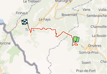
Tour Wandern von 17 km verfügbar auf Wallis, Entremont, Orsières. Diese Tour wird von uru2010 vorgeschlagen.
Beschreibung
Départ : Relais d'Arpette, Arpette.
Arrivée : Hôtel de la Grande Ourse, 30 Le Betty, Trient. Tél : 41 27 722 17 54.
Randonnée faite le 30/6/2021.
Durée suivant le guide : 6h25. Ma durée réelle : 6h40.
Ort
Land:
Switzerland
Region :
Wallis
Abteilung/Provinz :
Entremont
Kommune :
Orsières
Standort:
Unknown
Gehen Sie:(Dec)
Gehen Sie:(UTM)
352424 ; 5099119 (32T) N.
Kommentare
Touren in der Umgebung
![Tour Zu Fuß Orsières - Chemins pédestre de montagne, commune d'Orsières - Photo](https://media.geolcdn.com/t/375/260/6dfeee0d-887b-4c9c-aefd-3dcd0ea22569.jpeg&format=jpg&maxdim=2)
![Zu Fuß Zu Fuß](https://static1.geolcdn.com/sitytour/trail-icons/100.png)
Chemins pédestre de montagne, commune d'Orsières
Zu Fuß
Einfach
Orsières,
Wallis,
Entremont,
Switzerland
![](/images/other/stat-length.png)
5,6 km | 8,8 km-effort
1h 59min
![](https://static1.geolcdn.com/siteimages/upload/files/16400158638029165_repeat_loop_refresh_sync_direction_icon.png)
Nein
![Tour Zu Fuß Orsières - sentier du Devin - Photo](https://media.geolcdn.com/t/375/260/1486fc85-352e-404e-b600-0f3d7bac1924.jpeg&format=jpg&maxdim=2)
![Zu Fuß Zu Fuß](https://static1.geolcdn.com/sitytour/trail-icons/100.png)
sentier du Devin
Zu Fuß
Einfach
Orsières,
Wallis,
Entremont,
Switzerland
![](/images/other/stat-length.png)
3,9 km | 6,7 km-effort
1h 31min
![](https://static1.geolcdn.com/siteimages/upload/files/16400158638029165_repeat_loop_refresh_sync_direction_icon.png)
Ja
![Tour Zu Fuß Orsières - Chemins pédestre, commune d'Orsières - Photo](https://media.geolcdn.com/t/375/260/70edd484-9073-4e02-96d0-3d17425bab34.jpeg&format=jpg&maxdim=2)
![Zu Fuß Zu Fuß](https://static1.geolcdn.com/sitytour/trail-icons/100.png)
Chemins pédestre, commune d'Orsières
Zu Fuß
Einfach
Orsières,
Wallis,
Entremont,
Switzerland
![](/images/other/stat-length.png)
5,4 km | 14,1 km-effort
3h 12min
![](https://static1.geolcdn.com/siteimages/upload/files/16400158638029165_repeat_loop_refresh_sync_direction_icon.png)
Nein
![Tour Zu Fuß Bovernier - Chemins pédestre de montagne, région Entremont - Photo](https://media.geolcdn.com/t/375/260/8965cd81-5f88-4628-9726-209c4b98c789.jpeg&format=jpg&maxdim=2)
![Zu Fuß Zu Fuß](https://static1.geolcdn.com/sitytour/trail-icons/100.png)
Chemins pédestre de montagne, région Entremont
Zu Fuß
Medium
Bovernier,
Wallis,
Martinach,
Switzerland
![](/images/other/stat-length.png)
6,9 km | 22 km-effort
4h 54min
![](https://static1.geolcdn.com/siteimages/upload/files/16400158638029165_repeat_loop_refresh_sync_direction_icon.png)
Nein
![Tour Zu Fuß Orsières - Raccard du blé - Photo](https://media.geolcdn.com/t/375/260/e3af305e-4edc-4919-bcad-22d8b69ac232.jpeg&format=jpg&maxdim=2)
![Zu Fuß Zu Fuß](https://static1.geolcdn.com/sitytour/trail-icons/100.png)
Raccard du blé
Zu Fuß
Einfach
Orsières,
Wallis,
Entremont,
Switzerland
![](/images/other/stat-length.png)
7,9 km | 13,7 km-effort
3h 6min
![](https://static1.geolcdn.com/siteimages/upload/files/16400158638029165_repeat_loop_refresh_sync_direction_icon.png)
Ja
![Tour Schneeschuhwandern Orsières - Champex Lac - La Breya - Champex Lac - Photo](https://media.geolcdn.com/t/375/260/6555df26-5e72-41d3-9ea4-2761199f667f.jpg&format=jpg&maxdim=2)
![Schneeschuhwandern Schneeschuhwandern](https://static1.geolcdn.com/sitytour/trail-icons/504.png)
Champex Lac - La Breya - Champex Lac
Schneeschuhwandern
Medium
Orsières,
Wallis,
Entremont,
Switzerland
![](/images/other/stat-length.png)
8,8 km | 18,2 km-effort
3h 1min
![](https://static1.geolcdn.com/siteimages/upload/files/16400158638029165_repeat_loop_refresh_sync_direction_icon.png)
Ja
![Tour Wandern Orsières - CMX ZRMT Étape 2 Champex Cabane de Mille - Photo](https://media.geolcdn.com/t/375/260/ext.jpg?maxdim=2&url=https%3A%2F%2Fservices.sitytrail.com%2FGeolivesWS%2FDownloadMedia.ashx%3FTrailID%3D635928%26Media%3Dfix__20160914135625.jpg)
![Wandern Wandern](https://static1.geolcdn.com/sitytour/trail-icons/101.png)
CMX ZRMT Étape 2 Champex Cabane de Mille
Wandern
Medium
Orsières,
Wallis,
Entremont,
Switzerland
![](/images/other/stat-length.png)
17,9 km | 38 km-effort
7h 15min
![](https://static1.geolcdn.com/siteimages/upload/files/16400158638029165_repeat_loop_refresh_sync_direction_icon.png)
Nein
![Tour Wandern Orsières - TMB day 5 - Photo](https://media.geolcdn.com/t/375/260/ext.jpg?maxdim=2&url=https%3A%2F%2Fservices.sitytrail.com%2FGeolivesWS%2FDownloadMedia.ashx%3FTrailID%3D477598%26Media%3D393e1b86-eaa0-4b2d-a1d7-a6d5bce0c2e5.jpg)
![Wandern Wandern](https://static1.geolcdn.com/sitytour/trail-icons/101.png)
TMB day 5
Wandern
Medium
Orsières,
Wallis,
Entremont,
Switzerland
![](/images/other/stat-length.png)
16,7 km | 28 km-effort
6h 15min
![](https://static1.geolcdn.com/siteimages/upload/files/16400158638029165_repeat_loop_refresh_sync_direction_icon.png)
Nein
![Tour Wandern Orsières - tmb2024 étape 7 - Photo](https://media.geolcdn.com/t/375/260/9fff1a6e-f61e-46ab-9617-db3eb99f0d61.jpg&format=jpg&maxdim=2)
![Wandern Wandern](https://static1.geolcdn.com/sitytour/trail-icons/101.png)
tmb2024 étape 7
Wandern
Einfach
Orsières,
Wallis,
Entremont,
Switzerland
![](/images/other/stat-length.png)
15,1 km | 26 km-effort
7h 16min
![](https://static1.geolcdn.com/siteimages/upload/files/16400158638029165_repeat_loop_refresh_sync_direction_icon.png)
Nein