![](/images/other/stat-length.png)
![Tour Zu Fuß Dammartin-en-Goële - Dammartin PR 1 7.4 KM - Photo](https://media.geolcdn.com/t/1900/400/ext.pjpeg?maxdim=2&url=https%3A%2F%2Fstatic1.geolcdn.com%2Fsiteimages%2Fupload%2Ffiles%2F1545311037marcheuse_200dpi.jpg)
Dammartin PR 1 7.4 KM
GOELERANDO2
Benutzer
![Länge](/images/other/stat-length.png)
![Maximale Höhe](https://static1.geolcdn.com/siteimages/upload/files/1508320355ic_sort_altitude_max_24dp.png)
![Positive Höhendifferenz](https://static1.geolcdn.com/siteimages/upload/files/1508320355ic_sort_den_pos_24dp.png)
![Km-Effort](/images/other/stat-length.png)
![Min. Höhe](https://static1.geolcdn.com/siteimages/upload/files/1508320355ic_sort_altitude_min_24dp.png)
![Negative Höhendifferenz](https://static1.geolcdn.com/siteimages/upload/files/1508320355ic_sort_den_neg_24dp.png)
![Boucle](https://static1.geolcdn.com/siteimages/upload/files/16400158638029165_repeat_loop_refresh_sync_direction_icon.png)
![Zu Fuß](https://static1.geolcdn.com/sitytour/trail-icons/100.png)
2h03
Schwierigkeit : Einfach
![Scannen Sie diesen QR-Code, um die Tour in der SityTrail-Anwendung zu öffnen](https://capi.geolives.com/qq0zvz2zws4bq2lad0pu/sitytour/trails/2837552/qr.png?size=200)
Kostenlosegpshiking-Anwendung
Über SityTrail
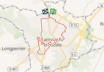
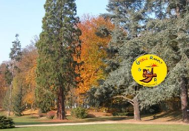
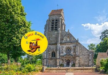
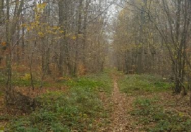
Tour Zu Fuß von 7,4 km verfügbar auf Île-de-France, Seine-et-Marne, Dammartin-en-Goële. Diese Tour wird von GOELERANDO2 vorgeschlagen.
Beschreibung
Tour de la nouvelle ville en partant du parking du collège de l'Europe au bas du Mont de la Goêle, pour s'élever vers l'ancien village par le chemin du petit Puits. Passer par l'ancienne Mairie, la collégiale, les parcs du Château, de la Corbie, Patrick Ledu, les jardins des filoirs. Redescendre par la zone pavillonnaires des anciens vergers de la Tuilerie, puis arriver au parking par la coulée verte.
Ort
Kommentare
Touren in der Umgebung
![Tour Wandern Montgé-en-Goële - MR_MONTGE-en-GOELE_5.3Km - Photo](https://media.geolcdn.com/t/375/260/35addc96-117d-441b-96c3-8a9f60ce0ef4.jpg&format=jpg&maxdim=2)
![Wandern Wandern](https://static1.geolcdn.com/sitytour/trail-icons/101.png)
Wandern
![](/images/other/stat-length.png)
![](https://static1.geolcdn.com/siteimages/upload/files/16400158638029165_repeat_loop_refresh_sync_direction_icon.png)
![Tour Zu Fuß Saint-Mard - Formation SITY TRAIL_SAINT MARD - Photo](https://media.geolcdn.com/t/375/260/ba3d62a0-8f58-458e-9ed8-b3b717ccdf4f.jpg&format=jpg&maxdim=2)
![Zu Fuß Zu Fuß](https://static1.geolcdn.com/sitytour/trail-icons/100.png)
Zu Fuß
![](/images/other/stat-length.png)
![](https://static1.geolcdn.com/siteimages/upload/files/16400158638029165_repeat_loop_refresh_sync_direction_icon.png)
![Tour Wandern Othis - SM_BEAUMARCHAIS_8.2Km - Photo](https://media.geolcdn.com/t/375/260/77e12fa5-e8b4-47fd-984a-c11823705817.jpg&format=jpg&maxdim=2)
![Wandern Wandern](https://static1.geolcdn.com/sitytour/trail-icons/101.png)
Wandern
![](/images/other/stat-length.png)
![](https://static1.geolcdn.com/siteimages/upload/files/16400158638029165_repeat_loop_refresh_sync_direction_icon.png)
![Tour Wandern Moussy-le-Vieux - SM_MOUSSY-le-VIEUX_8Km - Photo](https://media.geolcdn.com/t/375/260/03922300-8053-4584-b2fa-3cc394c6dd6a.jpg&format=jpg&maxdim=2)
![Wandern Wandern](https://static1.geolcdn.com/sitytour/trail-icons/101.png)
Wandern
![](/images/other/stat-length.png)
![](https://static1.geolcdn.com/siteimages/upload/files/16400158638029165_repeat_loop_refresh_sync_direction_icon.png)
![Tour Wandern Othis - SM_OTHIS-(PR Gérard de NERVAL)-Parc Beaupre_8.4Km - Photo](https://media.geolcdn.com/t/375/260/14c3ca26-f317-4a5a-aaff-75fa15b629d2.jpg&format=jpg&maxdim=2)
![Wandern Wandern](https://static1.geolcdn.com/sitytour/trail-icons/101.png)
Wandern
![](/images/other/stat-length.png)
![](https://static1.geolcdn.com/siteimages/upload/files/16400158638029165_repeat_loop_refresh_sync_direction_icon.png)
![Tour Wandern Saint-Mard - Le tour du grand Paris via le GR1 Etape 9 Dammartin en Goele - Meaux - Photo](https://media.geolcdn.com/t/375/260/c2b9ac23-3f31-4bcb-a8f1-c9edbe9e7c1b.jpg&format=jpg&maxdim=2)
![Wandern Wandern](https://static1.geolcdn.com/sitytour/trail-icons/101.png)
Wandern
![](/images/other/stat-length.png)
![](https://static1.geolcdn.com/siteimages/upload/files/16400158638029165_repeat_loop_refresh_sync_direction_icon.png)
![Tour Wandern Dammartin-en-Goële - Dammartin en Goële RC 2016 Grand parcours - Photo](https://media.geolcdn.com/t/375/260/ext.jpg?maxdim=2&url=https%3A%2F%2Fstatic1.geolcdn.com%2Fsiteimages%2Fupload%2Ffiles%2F1553511878bg_sport_marche.png)
![Wandern Wandern](https://static1.geolcdn.com/sitytour/trail-icons/101.png)
Wandern
![](/images/other/stat-length.png)
![](https://static1.geolcdn.com/siteimages/upload/files/16400158638029165_repeat_loop_refresh_sync_direction_icon.png)
![Tour Wandern Othis - CRAB : Othis - Photo](https://media.geolcdn.com/t/375/260/ext.jpg?maxdim=2&url=https%3A%2F%2Fservices.sitytrail.com%2FGeolivesWS%2FDownloadMedia.ashx%3FTrailID%3D662497%26Media%3Dfix__20161120141317.jpg)
![Wandern Wandern](https://static1.geolcdn.com/sitytour/trail-icons/101.png)
Wandern
![](/images/other/stat-length.png)
![](https://static1.geolcdn.com/siteimages/upload/files/16400158638029165_repeat_loop_refresh_sync_direction_icon.png)
![Tour Wandern Montgé-en-Goële - Montgé en Goële - Photo](https://media.geolcdn.com/t/375/260/ext.jpg?maxdim=2&url=https%3A%2F%2Fservices.sitytrail.com%2FGeolivesWS%2FDownloadMedia.ashx%3FTrailID%3D513911%26Media%3Dfix__20160117154857.jpg)
![Wandern Wandern](https://static1.geolcdn.com/sitytour/trail-icons/101.png)
Wandern
![](/images/other/stat-length.png)
![](https://static1.geolcdn.com/siteimages/upload/files/16400158638029165_repeat_loop_refresh_sync_direction_icon.png)