![](/images/other/stat-length.png)
![Tour Wandern Mens - Le Chatel et retour par col de la brèche - Photo](https://media.geolcdn.com/t/1900/400/ext.pjpeg?maxdim=2&url=https%3A%2F%2Fstatic1.geolcdn.com%2Fsiteimages%2Fupload%2Ffiles%2F1553511878bg_sport_marche.png)
Le Chatel et retour par col de la brèche
Annie21
Benutzer
![Länge](/images/other/stat-length.png)
Länge
9,6 km
![Maximale Höhe](https://static1.geolcdn.com/siteimages/upload/files/1508320355ic_sort_altitude_max_24dp.png)
Maximale Höhe
1930 m
![Positive Höhendifferenz](https://static1.geolcdn.com/siteimages/upload/files/1508320355ic_sort_den_pos_24dp.png)
Positive Höhendifferenz
701 m
![Km-Effort](/images/other/stat-length.png)
Km-Effort
18,9 km
![Min. Höhe](https://static1.geolcdn.com/siteimages/upload/files/1508320355ic_sort_altitude_min_24dp.png)
Min. Höhe
1289 m
![Negative Höhendifferenz](https://static1.geolcdn.com/siteimages/upload/files/1508320355ic_sort_den_neg_24dp.png)
Negative Höhendifferenz
700 m
![Boucle](https://static1.geolcdn.com/siteimages/upload/files/16400158638029165_repeat_loop_refresh_sync_direction_icon.png)
Boucle
Ja
Erstellungsdatum :
2021-06-18 08:39:17.808
Letzte Änderung :
2021-06-18 15:06:37.309
![Wandern](https://static1.geolcdn.com/sitytour/trail-icons/101.png)
4h34
Schwierigkeit : Medium
![Scannen Sie diesen QR-Code, um die Tour in der SityTrail-Anwendung zu öffnen](https://capi.geolives.com/qq0zvz2zws4bq2lad0pu/sitytour/trails/2831064/qr.png?size=200)
Kostenlosegpshiking-Anwendung
Über SityTrail
Tour Wandern von 9,6 km verfügbar auf Auvergne-Rhone-Alpen, Isère, Mens. Diese Tour wird von Annie21 vorgeschlagen.
Beschreibung
Rando à faire plutôt dans ce sens, car le sentier de retour est très bien, hormis deux court passages délicats sans problème. Très belle vue sur l'Obiou et le grand Ferrant.
Ort
Land:
France
Region :
Auvergne-Rhone-Alpen
Abteilung/Provinz :
Isère
Kommune :
Mens
Standort:
Unknown
Gehen Sie:(Dec)
Gehen Sie:(UTM)
720657 ; 4966900 (31T) N.
Kommentare
Touren in der Umgebung
![Tour Wandern Châtel-en-Trièves - Arête de Rattier depuis le col de la brêche - Photo](https://media.geolcdn.com/t/375/260/645aac14-c825-4b01-9c22-da781fdfea33.jpg&format=jpg&maxdim=2)
![Wandern Wandern](https://static1.geolcdn.com/sitytour/trail-icons/101.png)
Arête de Rattier depuis le col de la brêche
Wandern
Schwierig
(1)
Châtel-en-Trièves,
Auvergne-Rhone-Alpen,
Isère,
France
![](/images/other/stat-length.png)
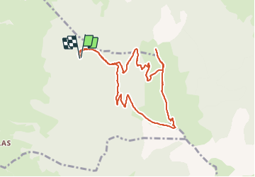
10,3 km | 24 km-effort
8h 12min
![](https://static1.geolcdn.com/siteimages/upload/files/16400158638029165_repeat_loop_refresh_sync_direction_icon.png)
Ja
![Tour Wandern Mens - Bonnet Calvin reco - Photo](https://media.geolcdn.com/t/375/260/71237d58-2b29-4521-9351-2dded8929675.jpg&format=jpg&maxdim=2)
![Wandern Wandern](https://static1.geolcdn.com/sitytour/trail-icons/101.png)
Bonnet Calvin reco
Wandern
Schwierig
(1)
Mens,
Auvergne-Rhone-Alpen,
Isère,
France
![](/images/other/stat-length.png)
10,7 km | 21 km-effort
4h 25min
![](https://static1.geolcdn.com/siteimages/upload/files/16400158638029165_repeat_loop_refresh_sync_direction_icon.png)
Nein
![Tour Wandern Saint-Baudille-et-Pipet - Bonnet de Calvin - Photo](https://media.geolcdn.com/t/375/260/b711d778-2624-48ca-9a09-33141db7aca2.jpg&format=jpg&maxdim=2)
![Wandern Wandern](https://static1.geolcdn.com/sitytour/trail-icons/101.png)
Bonnet de Calvin
Wandern
Medium
Saint-Baudille-et-Pipet,
Auvergne-Rhone-Alpen,
Isère,
France
![](/images/other/stat-length.png)
15 km | 31 km-effort
6h 35min
![](https://static1.geolcdn.com/siteimages/upload/files/16400158638029165_repeat_loop_refresh_sync_direction_icon.png)
Ja
![Tour Wandern Saint-Baudille-et-Pipet - Des Lames d'Arçon au Col de l'Aiguille - Photo](https://media.geolcdn.com/t/375/260/6a7d919f-0a46-4fb6-a03a-1cd4dec1d339.jpg&format=jpg&maxdim=2)
![Wandern Wandern](https://static1.geolcdn.com/sitytour/trail-icons/101.png)
Des Lames d'Arçon au Col de l'Aiguille
Wandern
Sehr schwierig
Saint-Baudille-et-Pipet,
Auvergne-Rhone-Alpen,
Isère,
France
![](/images/other/stat-length.png)
14,9 km | 31 km-effort
6h 56min
![](https://static1.geolcdn.com/siteimages/upload/files/16400158638029165_repeat_loop_refresh_sync_direction_icon.png)
Ja
![Tour Wandern Mens - bonnet de Calvin - Photo](https://media.geolcdn.com/t/375/260/809ecc75-03b4-4bae-9bda-776611be3043.jpg&format=jpg&maxdim=2)
![Wandern Wandern](https://static1.geolcdn.com/sitytour/trail-icons/101.png)
bonnet de Calvin
Wandern
Medium
Mens,
Auvergne-Rhone-Alpen,
Isère,
France
![](/images/other/stat-length.png)
8,3 km | 16,9 km-effort
6h 10min
![](https://static1.geolcdn.com/siteimages/upload/files/16400158638029165_repeat_loop_refresh_sync_direction_icon.png)
Ja
![Tour Wandern Mens - Esclops Trièves Tour de Mens - Photo](https://media.geolcdn.com/t/375/260/009e9f5f-8365-4132-9701-b10e3311f406.jpg&format=jpg&maxdim=2)
![Wandern Wandern](https://static1.geolcdn.com/sitytour/trail-icons/101.png)
Esclops Trièves Tour de Mens
Wandern
Einfach
Mens,
Auvergne-Rhone-Alpen,
Isère,
France
![](/images/other/stat-length.png)
17,7 km | 26 km-effort
6h 40min
![](https://static1.geolcdn.com/siteimages/upload/files/16400158638029165_repeat_loop_refresh_sync_direction_icon.png)
Ja
![Tour Wandern Saint-Baudille-et-Pipet - Esclops Trièves Col de l'Aiguille - Photo](https://media.geolcdn.com/t/375/260/c1c5675d-bfe6-4e05-80f5-bbfac132efec.jpg&format=jpg&maxdim=2)
![Wandern Wandern](https://static1.geolcdn.com/sitytour/trail-icons/101.png)
Esclops Trièves Col de l'Aiguille
Wandern
Schwierig
Saint-Baudille-et-Pipet,
Auvergne-Rhone-Alpen,
Isère,
France
![](/images/other/stat-length.png)
13,3 km | 27 km-effort
5h 46min
![](https://static1.geolcdn.com/siteimages/upload/files/16400158638029165_repeat_loop_refresh_sync_direction_icon.png)
Ja
![Tour Wandern Saint-Baudille-et-Pipet - Col de la l'Aiguille - Photo](https://media.geolcdn.com/t/375/260/2743f076-6474-4350-bcdf-a04402ad0013.jpg&format=jpg&maxdim=2)
![Wandern Wandern](https://static1.geolcdn.com/sitytour/trail-icons/101.png)
Col de la l'Aiguille
Wandern
Medium
Saint-Baudille-et-Pipet,
Auvergne-Rhone-Alpen,
Isère,
France
![](/images/other/stat-length.png)
13,3 km | 26 km-effort
4h 10min
![](https://static1.geolcdn.com/siteimages/upload/files/16400158638029165_repeat_loop_refresh_sync_direction_icon.png)
Ja
![Tour Elektrofahrrad Saint-Baudille-et-Pipet - Sainte Baudille de Pipet - St Pancrasse - Photo](https://media.geolcdn.com/t/375/260/98775b0d-8be1-4414-b804-8cc2ea33e09e.jpg&format=jpg&maxdim=2)
![Elektrofahrrad Elektrofahrrad](https://static1.geolcdn.com/sitytour/trail-icons/205.png)
Sainte Baudille de Pipet - St Pancrasse
Elektrofahrrad
Einfach
Saint-Baudille-et-Pipet,
Auvergne-Rhone-Alpen,
Isère,
France
![](/images/other/stat-length.png)
34 km | 46 km-effort
3h 36min
![](https://static1.geolcdn.com/siteimages/upload/files/16400158638029165_repeat_loop_refresh_sync_direction_icon.png)
Ja