![](/images/other/stat-length.png)
![Tour Wandern Thiézac - GR 400 J3 réel 14 160m +846m - Photo](https://media.geolcdn.com/t/1900/400/ext.pjpeg?maxdim=2&url=https%3A%2F%2Fstatic1.geolcdn.com%2Fsiteimages%2Fupload%2Ffiles%2F1553511878bg_sport_marche.png)
GR 400 J3 réel 14 160m +846m
DanielROLLET
Benutzer
![Länge](/images/other/stat-length.png)
Länge
14,2 km
![Maximale Höhe](https://static1.geolcdn.com/siteimages/upload/files/1508320355ic_sort_altitude_max_24dp.png)
Maximale Höhe
1552 m
![Positive Höhendifferenz](https://static1.geolcdn.com/siteimages/upload/files/1508320355ic_sort_den_pos_24dp.png)
Positive Höhendifferenz
846 m
![Km-Effort](/images/other/stat-length.png)
Km-Effort
25 km
![Min. Höhe](https://static1.geolcdn.com/siteimages/upload/files/1508320355ic_sort_altitude_min_24dp.png)
Min. Höhe
803 m
![Negative Höhendifferenz](https://static1.geolcdn.com/siteimages/upload/files/1508320355ic_sort_den_neg_24dp.png)
Negative Höhendifferenz
720 m
![Boucle](https://static1.geolcdn.com/siteimages/upload/files/16400158638029165_repeat_loop_refresh_sync_direction_icon.png)
Boucle
Nein
Erstellungsdatum :
2021-06-16 06:24:21.976
Letzte Änderung :
2021-06-26 08:41:21.241
![Wandern](https://static1.geolcdn.com/sitytour/trail-icons/101.png)
7h55
Schwierigkeit : Schwierig
![Scannen Sie diesen QR-Code, um die Tour in der SityTrail-Anwendung zu öffnen](https://capi.geolives.com/qq0zvz2zws4bq2lad0pu/sitytour/trails/2828952/qr.png?size=200)
Kostenlosegpshiking-Anwendung
Über SityTrail
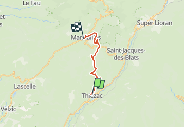
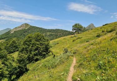
Tour Wandern von 14,2 km verfügbar auf Auvergne-Rhone-Alpen, Cantal, Thiézac. Diese Tour wird von DanielROLLET vorgeschlagen.
Beschreibung
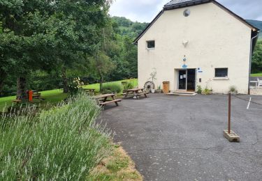
2021 06 16 8h20 à 16h15 Pause 13h00 à 13h30
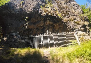
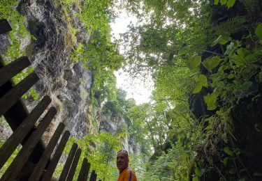
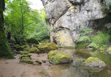
Pas de problème particulier mais descentes de l'Elancèze et vallon des Marias assez raides
Ort
Land:
France
Region :
Auvergne-Rhone-Alpen
Abteilung/Provinz :
Cantal
Kommune :
Thiézac
Standort:
Unknown
Gehen Sie:(Dec)
Gehen Sie:(UTM)
473629 ; 4984608 (31T) N.
Kommentare
Touren in der Umgebung
![Tour Wandern Thiézac - La Porte du Lion - Thiézac - Photo](https://media.geolcdn.com/t/375/260/ext.jpg?maxdim=2&url=https%3A%2F%2Fservices.sitytrail.com%2FGeolivesWS%2FDownloadMedia.ashx%3FTrailID%3D129644%26Media%3D13165_3.jpg)
![Wandern Wandern](https://static1.geolcdn.com/sitytour/trail-icons/101.png)
La Porte du Lion - Thiézac
Wandern
Medium
(2)
Thiézac,
Auvergne-Rhone-Alpen,
Cantal,
France
![](/images/other/stat-length.png)
6,6 km | 10,5 km-effort
3h 0min
![](https://static1.geolcdn.com/siteimages/upload/files/16400158638029165_repeat_loop_refresh_sync_direction_icon.png)
Ja
![Wandern Wandern](https://static1.geolcdn.com/sitytour/trail-icons/101.png)
Pailherols route de la montagne, plomb du Cantal
Wandern
Medium
Pailherols,
Auvergne-Rhone-Alpen,
Cantal,
France
![](/images/other/stat-length.png)
22 km | 32 km-effort
7h 21min
![](https://static1.geolcdn.com/siteimages/upload/files/16400158638029165_repeat_loop_refresh_sync_direction_icon.png)
Ja
![Tour Wandern Thiézac - Puy de la poche - Photo](https://media.geolcdn.com/t/375/260/f3ce84a8-7fd4-461e-ae03-56b4255cfce0.jpg&format=jpg&maxdim=2)
![Wandern Wandern](https://static1.geolcdn.com/sitytour/trail-icons/101.png)
Puy de la poche
Wandern
Einfach
Thiézac,
Auvergne-Rhone-Alpen,
Cantal,
France
![](/images/other/stat-length.png)
13,1 km | 23 km-effort
3h 14min
![](https://static1.geolcdn.com/siteimages/upload/files/16400158638029165_repeat_loop_refresh_sync_direction_icon.png)
Ja
![Tour Wandern Thiézac - La porte du Lion - Thiézac - Photo](https://media.geolcdn.com/t/375/260/ext.jpg?maxdim=2&url=https%3A%2F%2Fstatic1.geolcdn.com%2Fsiteimages%2Fupload%2Ffiles%2F1553511878bg_sport_marche.png)
![Wandern Wandern](https://static1.geolcdn.com/sitytour/trail-icons/101.png)
La porte du Lion - Thiézac
Wandern
Medium
(2)
Thiézac,
Auvergne-Rhone-Alpen,
Cantal,
France
![](/images/other/stat-length.png)
7,6 km | 11,5 km-effort
3h 30min
![](https://static1.geolcdn.com/siteimages/upload/files/16400158638029165_repeat_loop_refresh_sync_direction_icon.png)
Ja
![Tour Pfad Vic-sur-Cère - Cascade, la Garde, grotte des anglais - Photo](https://media.geolcdn.com/t/375/260/2f654d5e-2308-4101-8214-c057fbfbda64.jpg&format=jpg&maxdim=2)
![Pfad Pfad](https://static1.geolcdn.com/sitytour/trail-icons/104.png)
Cascade, la Garde, grotte des anglais
Pfad
Einfach
Vic-sur-Cère,
Auvergne-Rhone-Alpen,
Cantal,
France
![](/images/other/stat-length.png)
9,2 km | 16,7 km-effort
1h 49min
![](https://static1.geolcdn.com/siteimages/upload/files/16400158638029165_repeat_loop_refresh_sync_direction_icon.png)
Ja
![Tour Wandern Vic-sur-Cère - Pas de Cère- cascade de Gourdole - Photo](https://media.geolcdn.com/t/375/260/88d7000e-837e-4895-ace1-8d40f2abe4ca.jpg&format=jpg&maxdim=2)
![Wandern Wandern](https://static1.geolcdn.com/sitytour/trail-icons/101.png)
Pas de Cère- cascade de Gourdole
Wandern
Sehr leicht
Vic-sur-Cère,
Auvergne-Rhone-Alpen,
Cantal,
France
![](/images/other/stat-length.png)
4,7 km | 6,6 km-effort
2h 0min
![](https://static1.geolcdn.com/siteimages/upload/files/16400158638029165_repeat_loop_refresh_sync_direction_icon.png)
Ja
![Tour Wandern Thiézac - Les Gorges du Pas de Cère - Photo](https://media.geolcdn.com/t/375/260/fa38157b-57d6-4ad3-89fe-dcb1d3174ee5.jpg&format=jpg&maxdim=2)
![Wandern Wandern](https://static1.geolcdn.com/sitytour/trail-icons/101.png)
Les Gorges du Pas de Cère
Wandern
Einfach
Thiézac,
Auvergne-Rhone-Alpen,
Cantal,
France
![](/images/other/stat-length.png)
4,8 km | 6,8 km-effort
2h 21min
![](https://static1.geolcdn.com/siteimages/upload/files/16400158638029165_repeat_loop_refresh_sync_direction_icon.png)
Ja
![Tour Wandern Saint-Jacques-des-Blats - Grange Dévézou col du Pertus par col du Gliziou - Photo](https://media.geolcdn.com/t/375/260/879f5322-0936-4ccc-9e2f-1ca15de75463.jpg&format=jpg&maxdim=2)
![Wandern Wandern](https://static1.geolcdn.com/sitytour/trail-icons/101.png)
Grange Dévézou col du Pertus par col du Gliziou
Wandern
Einfach
Saint-Jacques-des-Blats,
Auvergne-Rhone-Alpen,
Cantal,
France
![](/images/other/stat-length.png)
16,8 km | 24 km-effort
4h 6min
![](https://static1.geolcdn.com/siteimages/upload/files/16400158638029165_repeat_loop_refresh_sync_direction_icon.png)
Ja
![Tour Wandern Thiézac - Moulin de Nierveze La grange de Dévézou - Photo](https://media.geolcdn.com/t/375/260/2366ecda-4615-4aaa-8890-5175d569027c.jpg&format=jpg&maxdim=2)
![Wandern Wandern](https://static1.geolcdn.com/sitytour/trail-icons/101.png)
Moulin de Nierveze La grange de Dévézou
Wandern
Sehr leicht
Thiézac,
Auvergne-Rhone-Alpen,
Cantal,
France
![](/images/other/stat-length.png)
5,6 km | 7,4 km-effort
1h 6min
![](https://static1.geolcdn.com/siteimages/upload/files/16400158638029165_repeat_loop_refresh_sync_direction_icon.png)
Nein