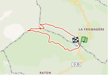
![](/images/other/stat-length.png)
![Tour Wandern Rosans - Montagne de Raton au départ du col de Pommerol ou de la Fromagère - Photo](https://media.geolcdn.com/t/1900/400/88563a29-0d69-4d1d-a9a8-ed2b63e53039.jpg&format=pjpeg&maxdim=2)
Montagne de Raton au départ du col de Pommerol ou de la Fromagère
jean-marie.parachini
Benutzer
![Länge](/images/other/stat-length.png)
![Maximale Höhe](https://static1.geolcdn.com/siteimages/upload/files/1508320355ic_sort_altitude_max_24dp.png)
![Positive Höhendifferenz](https://static1.geolcdn.com/siteimages/upload/files/1508320355ic_sort_den_pos_24dp.png)
![Km-Effort](/images/other/stat-length.png)
![Min. Höhe](https://static1.geolcdn.com/siteimages/upload/files/1508320355ic_sort_altitude_min_24dp.png)
![Negative Höhendifferenz](https://static1.geolcdn.com/siteimages/upload/files/1508320355ic_sort_den_neg_24dp.png)
![Boucle](https://static1.geolcdn.com/siteimages/upload/files/16400158638029165_repeat_loop_refresh_sync_direction_icon.png)
![Wandern](https://static1.geolcdn.com/sitytour/trail-icons/101.png)
7h29
Schwierigkeit : Medium
![Scannen Sie diesen QR-Code, um die Tour in der SityTrail-Anwendung zu öffnen](https://capi.geolives.com/qq0zvz2zws4bq2lad0pu/sitytour/trails/2821739/qr.png?size=200)
Kostenlosegpshiking-Anwendung
Über SityTrail
Tour Wandern von 6,8 km verfügbar auf Provence-Alpes-Côte d'Azur, Hochalpen, Rosans. Diese Tour wird von jean-marie.parachini vorgeschlagen.
Beschreibung
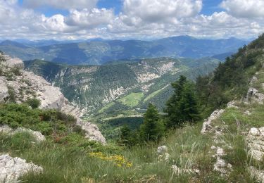
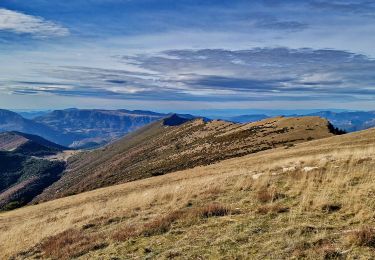
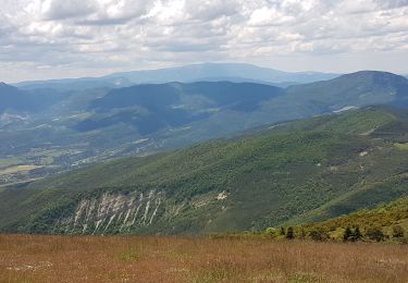
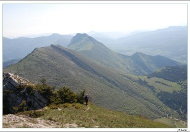
Panorama 360 ° sur les Alpes , le Dévoluy, les dentelles de montmirail, le Ventoux. Montée agréable à travers la forêt puis arrivée sur le sommet où l on peut se promener sur la crête. Parcours jalonné d une belle végétation, gentianes, lin bleu, cirses, campanules, heliantemes blanches, thym, lavande etc...
Ort
Kommentare
Touren in der Umgebung
![Tour Nordic Walking Rosans - Crêtes du raton à partir du col de Pommerol - Photo](https://media.geolcdn.com/t/375/260/ce74893b-bcd8-461a-8afe-7c5344df54b3.jpg&format=jpg&maxdim=2)
![Nordic Walking Nordic Walking](https://static1.geolcdn.com/sitytour/trail-icons/102.png)
Nordic Walking
![](/images/other/stat-length.png)
![](https://static1.geolcdn.com/siteimages/upload/files/16400158638029165_repeat_loop_refresh_sync_direction_icon.png)
![Tour Wandern Rosans - Le Fourchat - Photo](https://media.geolcdn.com/t/375/260/7f174db1-94bf-4048-baf9-e56696ece47f.jpg&format=jpg&maxdim=2)
![Wandern Wandern](https://static1.geolcdn.com/sitytour/trail-icons/101.png)
Wandern
![](/images/other/stat-length.png)
![](https://static1.geolcdn.com/siteimages/upload/files/16400158638029165_repeat_loop_refresh_sync_direction_icon.png)
![Tour Wandern Rosans - Crête de Raton Via Raton - Photo](https://media.geolcdn.com/t/375/260/3e9ccc6f-4f06-44dd-9d37-5eaabb2c9ea0.jpg&format=jpg&maxdim=2)
![Wandern Wandern](https://static1.geolcdn.com/sitytour/trail-icons/101.png)
Wandern
![](/images/other/stat-length.png)
![](https://static1.geolcdn.com/siteimages/upload/files/16400158638029165_repeat_loop_refresh_sync_direction_icon.png)
![Tour Wandern Rosans - 7km Fourchat AR par chemin du facteur (partie) - Photo](https://media.geolcdn.com/t/375/260/18cea4ea-f64c-464e-b93c-f5601bfe95d1.jpg&format=jpg&maxdim=2)
![Wandern Wandern](https://static1.geolcdn.com/sitytour/trail-icons/101.png)
Wandern
![](/images/other/stat-length.png)
![](https://static1.geolcdn.com/siteimages/upload/files/16400158638029165_repeat_loop_refresh_sync_direction_icon.png)
![Tour Wandern Rosans - Le Fourchat par le col de Pommerol - Photo](https://media.geolcdn.com/t/375/260/cfab902e-83fa-4d54-aaa2-8926b38ea959.jpg&format=jpg&maxdim=2)
![Wandern Wandern](https://static1.geolcdn.com/sitytour/trail-icons/101.png)
Wandern
![](/images/other/stat-length.png)
![](https://static1.geolcdn.com/siteimages/upload/files/16400158638029165_repeat_loop_refresh_sync_direction_icon.png)
![Tour Rennrad La Charce - 75km VC La Charce Montmorin Serres Carabès Valdrôme La Chance - Photo](https://media.geolcdn.com/t/375/260/ext.jpg?maxdim=2&url=https%3A%2F%2Fstatic1.geolcdn.com%2Fsiteimages%2Fupload%2Ffiles%2F1524743154velo.jpg)
![Rennrad Rennrad](https://static1.geolcdn.com/sitytour/trail-icons/201.png)
Rennrad
![](/images/other/stat-length.png)
![](https://static1.geolcdn.com/siteimages/upload/files/16400158638029165_repeat_loop_refresh_sync_direction_icon.png)
![Tour Wandern Rosans - POMMEROL - LA MONTAGNE DE RATON - Photo](https://media.geolcdn.com/t/375/260/904beef7-15df-4454-b310-e33a491109ff.jpg&format=jpg&maxdim=2)
![Wandern Wandern](https://static1.geolcdn.com/sitytour/trail-icons/101.png)
Wandern
![](/images/other/stat-length.png)
![](https://static1.geolcdn.com/siteimages/upload/files/16400158638029165_repeat_loop_refresh_sync_direction_icon.png)
![Tour Mountainbike Rosans - HA J2 long - Photo](https://media.geolcdn.com/t/375/260/ext.jpg?maxdim=2&url=https%3A%2F%2Fstatic1.geolcdn.com%2Fsiteimages%2Fupload%2Ffiles%2F1524743154velo.jpg)
![Mountainbike Mountainbike](https://static1.geolcdn.com/sitytour/trail-icons/202.png)
Mountainbike
![](/images/other/stat-length.png)
![](https://static1.geolcdn.com/siteimages/upload/files/16400158638029165_repeat_loop_refresh_sync_direction_icon.png)
![Tour Wandern Pommerol - Col de La Fromagère - Le Fourchat - Photo](https://media.geolcdn.com/t/375/260/ext.jpg?maxdim=2&url=https%3A%2F%2Fservices.sitytrail.com%2FGeolivesWS%2FDownloadMedia.ashx%3FTrailID%3D105097%26Media%3D8690_3.jpg)
![Wandern Wandern](https://static1.geolcdn.com/sitytour/trail-icons/101.png)
Wandern
![](/images/other/stat-length.png)
![](https://static1.geolcdn.com/siteimages/upload/files/16400158638029165_repeat_loop_refresh_sync_direction_icon.png)
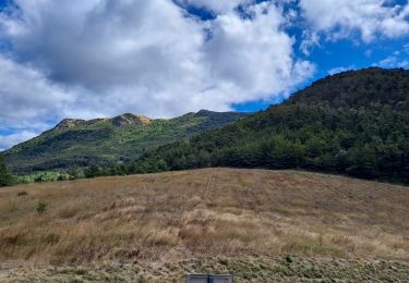
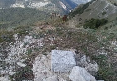
Difficile dans les deux sens mais avec une vue fantastique au sommet.