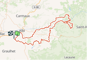
![](/images/other/stat-length.png)
![Tour Moto-Cross Aussac - Balade Brousse-le-Chateau, Vallée du Tarn - Photo](https://media.geolcdn.com/t/1900/400/3e518d80-9450-4e22-b5db-f3f89e0600b0.jpg&format=pjpeg&maxdim=2)
Balade Brousse-le-Chateau, Vallée du Tarn
jpipacific
Benutzer
![Länge](/images/other/stat-length.png)
![Maximale Höhe](https://static1.geolcdn.com/siteimages/upload/files/1508320355ic_sort_altitude_max_24dp.png)
![Positive Höhendifferenz](https://static1.geolcdn.com/siteimages/upload/files/1508320355ic_sort_den_pos_24dp.png)
![Km-Effort](/images/other/stat-length.png)
![Min. Höhe](https://static1.geolcdn.com/siteimages/upload/files/1508320355ic_sort_altitude_min_24dp.png)
![Negative Höhendifferenz](https://static1.geolcdn.com/siteimages/upload/files/1508320355ic_sort_den_neg_24dp.png)
![Boucle](https://static1.geolcdn.com/siteimages/upload/files/16400158638029165_repeat_loop_refresh_sync_direction_icon.png)
![Moto-Cross](https://static1.geolcdn.com/sitytour/trail-icons/406.png)
4h50
Schwierigkeit : Medium
![Scannen Sie diesen QR-Code, um die Tour in der SityTrail-Anwendung zu öffnen](https://capi.geolives.com/qq0zvz2zws4bq2lad0pu/sitytour/trails/2821552/qr.png?size=200)
Kostenlosegpshiking-Anwendung
Über SityTrail
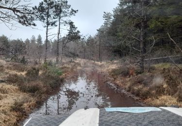
Tour Moto-Cross von 221 km verfügbar auf Okzitanien, Tarn, Aussac. Diese Tour wird von jpipacific vorgeschlagen.
Beschreibung
Fait avec Africa Twin CRF 1000 DCT en duo
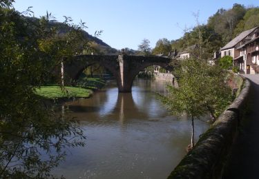
Magnifique balade. les points de vues se succèdent, les paysages sont splendides.
La route est parfois extrêmement étroite avec un revêtement spartiate. C'est bien d'avoir une moto Trail.
Très bon restaurant à Brousse le château (Hotel Le Relays du chasteau) Prix très raisonnable.
Ort
Kommentare
Touren in der Umgebung
![Moto-Cross Moto-Cross](https://static1.geolcdn.com/sitytour/trail-icons/406.png)
Moto-Cross
![](/images/other/stat-length.png)
![](https://static1.geolcdn.com/siteimages/upload/files/16400158638029165_repeat_loop_refresh_sync_direction_icon.png)
![Wandern Wandern](https://static1.geolcdn.com/sitytour/trail-icons/101.png)
Wandern
![](/images/other/stat-length.png)
![](https://static1.geolcdn.com/siteimages/upload/files/16400158638029165_repeat_loop_refresh_sync_direction_icon.png)
![Tour Moto-Cross Fénols - La route des seigneurs et chateaux Aveyronnais - Photo](https://media.geolcdn.com/t/375/260/cc55bc8b-c631-4d92-a303-1c1fc25e23b1.jpg&format=jpg&maxdim=2)
![Moto-Cross Moto-Cross](https://static1.geolcdn.com/sitytour/trail-icons/406.png)
Moto-Cross
![](/images/other/stat-length.png)
![](https://static1.geolcdn.com/siteimages/upload/files/16400158638029165_repeat_loop_refresh_sync_direction_icon.png)
![Tour Nordic Walking Florentin - Sentier des colombes Florentin - Photo](https://media.geolcdn.com/t/375/260/bae8b8d3-bb4b-475b-a413-6e83538ce8b1.jpg&format=jpg&maxdim=2)
![Nordic Walking Nordic Walking](https://static1.geolcdn.com/sitytour/trail-icons/102.png)
Nordic Walking
![](/images/other/stat-length.png)
![](https://static1.geolcdn.com/siteimages/upload/files/16400158638029165_repeat_loop_refresh_sync_direction_icon.png)
![Tour Wandern Orban - SityTrail - 3061378 - orban-chemin-des-cretes - Photo](https://media.geolcdn.com/t/375/260/26a0c344-fd25-47d2-a26d-446f19e423e5.jpg&format=jpg&maxdim=2)
![Wandern Wandern](https://static1.geolcdn.com/sitytour/trail-icons/101.png)
Wandern
![](/images/other/stat-length.png)
![](https://static1.geolcdn.com/siteimages/upload/files/16400158638029165_repeat_loop_refresh_sync_direction_icon.png)
![Tour 4x4 Fénols - Vabre Anglés Parc du haut Languedoc - Photo](https://media.geolcdn.com/t/375/260/efe61901-ab29-4794-b72e-2a76a5d8cb95.jpeg&format=jpg&maxdim=2)
![4x4 4x4](https://static1.geolcdn.com/sitytour/trail-icons/403.png)
4x4
![](/images/other/stat-length.png)
![](https://static1.geolcdn.com/siteimages/upload/files/16400158638029165_repeat_loop_refresh_sync_direction_icon.png)
![Tour Mountainbike Rouffiac - Circuit du Puech de Mourens - Rouffiac - Photo](https://media.geolcdn.com/t/375/260/ext.jpg?maxdim=2&url=https%3A%2F%2Fservices.sitytrail.com%2FGeolivesWS%2FDownloadMedia.ashx%3FTrailID%3D104295%26Media%3D7522_3.jpg)
![Mountainbike Mountainbike](https://static1.geolcdn.com/sitytour/trail-icons/202.png)
Mountainbike
![](/images/other/stat-length.png)
![](https://static1.geolcdn.com/siteimages/upload/files/16400158638029165_repeat_loop_refresh_sync_direction_icon.png)
![Tour Wandern Rouffiac - Circuit du Puech de Mourens - Rouffiac - Photo](https://media.geolcdn.com/t/375/260/ext.jpg?maxdim=2&url=https%3A%2F%2Fservices.sitytrail.com%2FGeolivesWS%2FDownloadMedia.ashx%3FTrailID%3D104294%26Media%3D7522_3.jpg)
![Wandern Wandern](https://static1.geolcdn.com/sitytour/trail-icons/101.png)
Wandern
![](/images/other/stat-length.png)
![](https://static1.geolcdn.com/siteimages/upload/files/16400158638029165_repeat_loop_refresh_sync_direction_icon.png)
![Wandern Wandern](https://static1.geolcdn.com/sitytour/trail-icons/101.png)
Wandern
![](/images/other/stat-length.png)
![](https://static1.geolcdn.com/siteimages/upload/files/16400158638029165_repeat_loop_refresh_sync_direction_icon.png)