![](/images/other/stat-length.png)
![Tour Wandern Nîmes - Bois de Mittau et bois des Espeisses - Photo](https://media.geolcdn.com/t/1900/400/fd77d31d-0511-4895-83d2-fe165d2e6345.jpg&format=pjpeg&maxdim=2)
Bois de Mittau et bois des Espeisses
jll7513
Benutzer
![Länge](/images/other/stat-length.png)
![Maximale Höhe](https://static1.geolcdn.com/siteimages/upload/files/1508320355ic_sort_altitude_max_24dp.png)
![Positive Höhendifferenz](https://static1.geolcdn.com/siteimages/upload/files/1508320355ic_sort_den_pos_24dp.png)
![Km-Effort](/images/other/stat-length.png)
![Min. Höhe](https://static1.geolcdn.com/siteimages/upload/files/1508320355ic_sort_altitude_min_24dp.png)
![Negative Höhendifferenz](https://static1.geolcdn.com/siteimages/upload/files/1508320355ic_sort_den_neg_24dp.png)
![Boucle](https://static1.geolcdn.com/siteimages/upload/files/16400158638029165_repeat_loop_refresh_sync_direction_icon.png)
![Wandern](https://static1.geolcdn.com/sitytour/trail-icons/101.png)
3h26
Schwierigkeit : Einfach
![Nordic Walking](https://static1.geolcdn.com/sitytour/trail-icons/102.png)
2h27
Schwierigkeit : Einfach
![Scannen Sie diesen QR-Code, um die Tour in der SityTrail-Anwendung zu öffnen](https://capi.geolives.com/qq0zvz2zws4bq2lad0pu/sitytour/trails/2819815/qr.png?size=200)
Kostenlosegpshiking-Anwendung
Über SityTrail
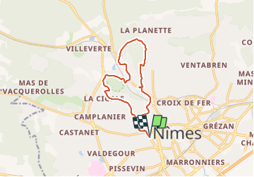
Tour Wandern von 12,7 km verfügbar auf Okzitanien, Gard, Nîmes. Diese Tour wird von jll7513 vorgeschlagen.
Beschreibung
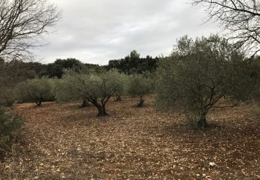
On commence du lycée Albert Camus puis on monte par le Cadereau, ensuite le bois de Mittau l'entrée se fait par un portail , car c'est une réserve de chasse, qui n'est pas fermé à clé. Quand on ressort du bois de Mitau on prend pendant un petit moment la route d'Alés pour aller vers le bois des Espeisses et redescendre par le chemin de la Cigale et retour par le Caderau.
Ort
Kommentare
Touren in der Umgebung
![Tour Wandern Nîmes - mon petit tour de Nîmes - Photo](https://media.geolcdn.com/t/375/260/8898b886-3b8d-4ecc-b456-add4f07fe1e8.jpg&format=jpg&maxdim=2)
![Wandern Wandern](https://static1.geolcdn.com/sitytour/trail-icons/101.png)
Wandern
![](/images/other/stat-length.png)
![](https://static1.geolcdn.com/siteimages/upload/files/16400158638029165_repeat_loop_refresh_sync_direction_icon.png)
![Tour Wandern Nîmes - Régordane 9 - Nîmes-St Gilles - Photo](https://media.geolcdn.com/t/375/260/90dc27dd-31da-4dc2-bb0f-b14a59878be6.jpg&format=jpg&maxdim=2)
![Wandern Wandern](https://static1.geolcdn.com/sitytour/trail-icons/101.png)
Wandern
![](/images/other/stat-length.png)
![](https://static1.geolcdn.com/siteimages/upload/files/16400158638029165_repeat_loop_refresh_sync_direction_icon.png)
![Tour Wandern Milhaud - Capitelles de Milhaud - Photo](https://media.geolcdn.com/t/375/260/ext.jpg?maxdim=2&url=https%3A%2F%2Fservices.sitytrail.com%2FGeolivesWS%2FDownloadMedia.ashx%3FTrailID%3D875103%26Media%3D20171213152313.jpg)
![Wandern Wandern](https://static1.geolcdn.com/sitytour/trail-icons/101.png)
Wandern
![](/images/other/stat-length.png)
![](https://static1.geolcdn.com/siteimages/upload/files/16400158638029165_repeat_loop_refresh_sync_direction_icon.png)
![Wandern Wandern](https://static1.geolcdn.com/sitytour/trail-icons/101.png)
Wandern
![](/images/other/stat-length.png)
![](https://static1.geolcdn.com/siteimages/upload/files/16400158638029165_repeat_loop_refresh_sync_direction_icon.png)
![Tour Wandern Nîmes - petite rando Combe des Bourguihnons - Photo](https://media.geolcdn.com/t/375/260/ext.jpg?maxdim=2&url=https%3A%2F%2Fstatic1.geolcdn.com%2Fsiteimages%2Fupload%2Ffiles%2F1553511878bg_sport_marche.png)
![Wandern Wandern](https://static1.geolcdn.com/sitytour/trail-icons/101.png)
Wandern
![](/images/other/stat-length.png)
![](https://static1.geolcdn.com/siteimages/upload/files/16400158638029165_repeat_loop_refresh_sync_direction_icon.png)
![Tour Wandern Nîmes - MARGUERITTES FONT D'AUBARNE - Photo](https://media.geolcdn.com/t/375/260/1451d501-8c4d-4904-a3a6-5ed534b8fb76.jpg&format=jpg&maxdim=2)
![Wandern Wandern](https://static1.geolcdn.com/sitytour/trail-icons/101.png)
Wandern
![](/images/other/stat-length.png)
![](https://static1.geolcdn.com/siteimages/upload/files/16400158638029165_repeat_loop_refresh_sync_direction_icon.png)
![Tour Wandern Nîmes - Courbessac - Escattes Solidarité - Photo](https://media.geolcdn.com/t/375/260/ea93c9f2-6d31-4437-8451-cf76c9e66090.jpg&format=jpg&maxdim=2)
![Wandern Wandern](https://static1.geolcdn.com/sitytour/trail-icons/101.png)
Wandern
![](/images/other/stat-length.png)
![](https://static1.geolcdn.com/siteimages/upload/files/16400158638029165_repeat_loop_refresh_sync_direction_icon.png)
![Tour Wandern Nîmes - Courbessac - Escattes Fort bis - Photo](https://media.geolcdn.com/t/375/260/ea93c9f2-6d31-4437-8451-cf76c9e66090.jpg&format=jpg&maxdim=2)
![Wandern Wandern](https://static1.geolcdn.com/sitytour/trail-icons/101.png)
Wandern
![](/images/other/stat-length.png)
![](https://static1.geolcdn.com/siteimages/upload/files/16400158638029165_repeat_loop_refresh_sync_direction_icon.png)
![Tour Wandern Nîmes - Courbessac - Escattes Faible - Photo](https://media.geolcdn.com/t/375/260/ea93c9f2-6d31-4437-8451-cf76c9e66090.jpg&format=jpg&maxdim=2)
![Wandern Wandern](https://static1.geolcdn.com/sitytour/trail-icons/101.png)
Wandern
![](/images/other/stat-length.png)
![](https://static1.geolcdn.com/siteimages/upload/files/16400158638029165_repeat_loop_refresh_sync_direction_icon.png)