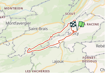
![](/images/other/stat-length.png)
![Tour Wandern Saulcy - Jura sauvage - Saulcy et les gorges du Tabeillon - Photo](https://media.geolcdn.com/t/1900/400/ext.pjpeg?maxdim=2&url=https%3A%2F%2Fstatic1.geolcdn.com%2Fsiteimages%2Fupload%2Ffiles%2F1553511878bg_sport_marche.png)
Jura sauvage - Saulcy et les gorges du Tabeillon
duamerg
Benutzer
![Länge](/images/other/stat-length.png)
![Maximale Höhe](https://static1.geolcdn.com/siteimages/upload/files/1508320355ic_sort_altitude_max_24dp.png)
![Positive Höhendifferenz](https://static1.geolcdn.com/siteimages/upload/files/1508320355ic_sort_den_pos_24dp.png)
![Km-Effort](/images/other/stat-length.png)
![Min. Höhe](https://static1.geolcdn.com/siteimages/upload/files/1508320355ic_sort_altitude_min_24dp.png)
![Negative Höhendifferenz](https://static1.geolcdn.com/siteimages/upload/files/1508320355ic_sort_den_neg_24dp.png)
![Boucle](https://static1.geolcdn.com/siteimages/upload/files/16400158638029165_repeat_loop_refresh_sync_direction_icon.png)
![Wandern](https://static1.geolcdn.com/sitytour/trail-icons/101.png)
4h18
Schwierigkeit : Medium
![Scannen Sie diesen QR-Code, um die Tour in der SityTrail-Anwendung zu öffnen](https://capi.geolives.com/qq0zvz2zws4bq2lad0pu/sitytour/trails/28178/qr.png?size=200)
Kostenlosegpshiking-Anwendung
Über SityTrail
Tour Wandern von 12,9 km verfügbar auf Jura, Bezirk Delsberg, Saulcy. Diese Tour wird von duamerg vorgeschlagen.
Beschreibung
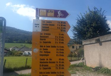
De Saulcy rejoindre 'sur les roches' en suivant les panneaux
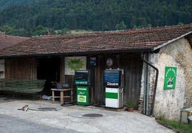
Descendre dans la combe. Restaurant de la gare.
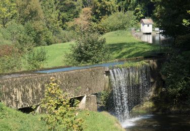
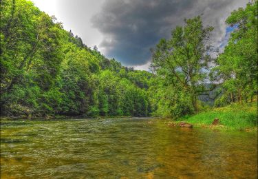
Suivre les panneaux 'combe Tabeillon' pour trouver un joli étang, des gorges et une barre rocheuse.
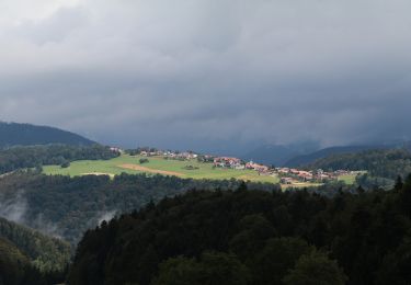
Forte montée pour retrouver le plateau de Saulcy.
Belle ballade intéressante et variée dans un vallon un peu inconnu.
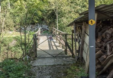
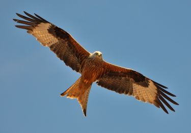
Voir photos.
Ort
Kommentare
Touren in der Umgebung
![Tour Zu Fuß Saulcy - Saulcy - Undervelier - Photo](https://media.geolcdn.com/t/375/260/ee051455-45e4-451a-9c39-ecddc506b7b5.jpeg&format=jpg&maxdim=2)
![Zu Fuß Zu Fuß](https://static1.geolcdn.com/sitytour/trail-icons/100.png)
Zu Fuß
![](/images/other/stat-length.png)
![](https://static1.geolcdn.com/siteimages/upload/files/16400158638029165_repeat_loop_refresh_sync_direction_icon.png)
![Tour Zu Fuß Saulcy - Saulcy - fixme - Photo](https://media.geolcdn.com/t/375/260/ac30ddf9-fb3f-420a-83a4-d7bfbdc6c2ce.jpeg&format=jpg&maxdim=2)
![Zu Fuß Zu Fuß](https://static1.geolcdn.com/sitytour/trail-icons/100.png)
Zu Fuß
![](/images/other/stat-length.png)
![](https://static1.geolcdn.com/siteimages/upload/files/16400158638029165_repeat_loop_refresh_sync_direction_icon.png)
![Tour Zu Fuß Haute-Sorne - Berlincourt - fixme - Photo](https://media.geolcdn.com/t/375/260/72357a19-7dbe-43be-a37e-91c3499414df.jpeg&format=jpg&maxdim=2)
![Zu Fuß Zu Fuß](https://static1.geolcdn.com/sitytour/trail-icons/100.png)
Zu Fuß
![](/images/other/stat-length.png)
![](https://static1.geolcdn.com/siteimages/upload/files/16400158638029165_repeat_loop_refresh_sync_direction_icon.png)
![Tour Zu Fuß Haute-Sorne - Berlincourt - La Racine - Photo](https://media.geolcdn.com/t/375/260/72357a19-7dbe-43be-a37e-91c3499414df.jpeg&format=jpg&maxdim=2)
![Zu Fuß Zu Fuß](https://static1.geolcdn.com/sitytour/trail-icons/100.png)
Zu Fuß
![](/images/other/stat-length.png)
![](https://static1.geolcdn.com/siteimages/upload/files/16400158638029165_repeat_loop_refresh_sync_direction_icon.png)
![Tour Zu Fuß Haute-Sorne - Undervelier - Berlincourt - Photo](https://media.geolcdn.com/t/375/260/ac30ddf9-fb3f-420a-83a4-d7bfbdc6c2ce.jpeg&format=jpg&maxdim=2)
![Zu Fuß Zu Fuß](https://static1.geolcdn.com/sitytour/trail-icons/100.png)
Zu Fuß
![](/images/other/stat-length.png)
![](https://static1.geolcdn.com/siteimages/upload/files/16400158638029165_repeat_loop_refresh_sync_direction_icon.png)
![Tour Zu Fuß Clos du Doubs - Passerelle de La Charbonniere - Soubey - Photo](https://media.geolcdn.com/t/375/260/827ab20e-fac6-4ddc-a128-657f5a8fe4c8.jpeg&format=jpg&maxdim=2)
![Zu Fuß Zu Fuß](https://static1.geolcdn.com/sitytour/trail-icons/100.png)
Zu Fuß
![](/images/other/stat-length.png)
![](https://static1.geolcdn.com/siteimages/upload/files/16400158638029165_repeat_loop_refresh_sync_direction_icon.png)
![Tour Zu Fuß Haute-Sorne - Glovelier-St.Ursanne - Photo](https://media.geolcdn.com/t/375/260/584913b5-9279-4d14-8e86-e875dfda0129.jpeg&format=jpg&maxdim=2)
![Zu Fuß Zu Fuß](https://static1.geolcdn.com/sitytour/trail-icons/100.png)
Zu Fuß
![](/images/other/stat-length.png)
![](https://static1.geolcdn.com/siteimages/upload/files/16400158638029165_repeat_loop_refresh_sync_direction_icon.png)
![Tour Zu Fuß Saint-Brais - Le Poye - fixme - Photo](https://media.geolcdn.com/t/375/260/091e7155-675e-45d4-8da6-1d843ef54918.jpeg&format=jpg&maxdim=2)
![Zu Fuß Zu Fuß](https://static1.geolcdn.com/sitytour/trail-icons/100.png)
Zu Fuß
![](/images/other/stat-length.png)
![](https://static1.geolcdn.com/siteimages/upload/files/16400158638029165_repeat_loop_refresh_sync_direction_icon.png)
![Tour Zu Fuß Saint-Brais - Tariche - Pont de Ravines - Photo](https://media.geolcdn.com/t/375/260/976f4996-25f5-4d97-aa6d-b26d356687f2.jpeg&format=jpg&maxdim=2)
![Zu Fuß Zu Fuß](https://static1.geolcdn.com/sitytour/trail-icons/100.png)
Zu Fuß
![](/images/other/stat-length.png)
![](https://static1.geolcdn.com/siteimages/upload/files/16400158638029165_repeat_loop_refresh_sync_direction_icon.png)