![](/images/other/stat-length.png)
![Tour Wandern Mazaugues - Mazaugues les Arches - Photo](https://media.geolcdn.com/t/1900/400/ext.pjpeg?maxdim=2&url=https%3A%2F%2Fmedia.geolcdn.com%2Ff%2Fb50461e0-4ae3-43ab-b3a0-34450283475c.jpg)
Mazaugues les Arches
cousam
Benutzer
![Länge](/images/other/stat-length.png)
Länge
13,5 km
![Maximale Höhe](https://static1.geolcdn.com/siteimages/upload/files/1508320355ic_sort_altitude_max_24dp.png)
Maximale Höhe
901 m
![Positive Höhendifferenz](https://static1.geolcdn.com/siteimages/upload/files/1508320355ic_sort_den_pos_24dp.png)
Positive Höhendifferenz
505 m
![Km-Effort](/images/other/stat-length.png)
Km-Effort
20 km
![Min. Höhe](https://static1.geolcdn.com/siteimages/upload/files/1508320355ic_sort_altitude_min_24dp.png)
Min. Höhe
510 m
![Negative Höhendifferenz](https://static1.geolcdn.com/siteimages/upload/files/1508320355ic_sort_den_neg_24dp.png)
Negative Höhendifferenz
504 m
![Boucle](https://static1.geolcdn.com/siteimages/upload/files/16400158638029165_repeat_loop_refresh_sync_direction_icon.png)
Boucle
Ja
Erstellungsdatum :
2021-06-03 09:39:17.808
Letzte Änderung :
2021-06-03 17:34:19.276
![Wandern](https://static1.geolcdn.com/sitytour/trail-icons/101.png)
4h29
Schwierigkeit : Medium
![Scannen Sie diesen QR-Code, um die Tour in der SityTrail-Anwendung zu öffnen](https://capi.geolives.com/qq0zvz2zws4bq2lad0pu/sitytour/trails/2812599/qr.png?size=200)
Kostenlosegpshiking-Anwendung
Über SityTrail
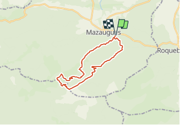
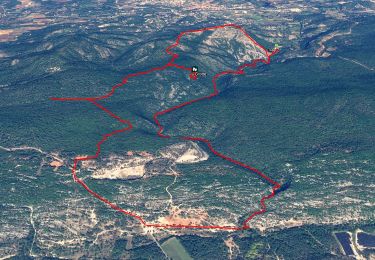
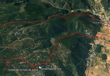
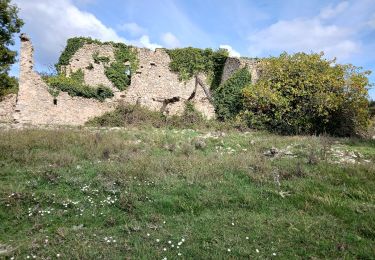
Tour Wandern von 13,5 km verfügbar auf Provence-Alpes-Côte d'Azur, Var, Mazaugues. Diese Tour wird von cousam vorgeschlagen.
Beschreibung
Montée par le petit sentier très sympa ,pour éviter le GR.
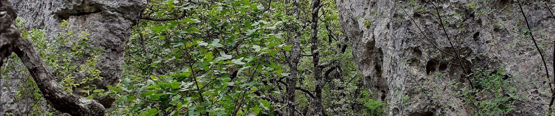
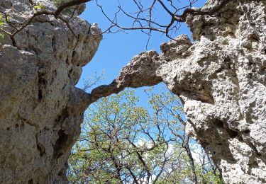
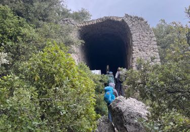
Aller à la recherche des arches,assez dissimulés par les arbres.
Retour par le sentier du vallon du Thuya.
(jackie Dominique)
Ort
Land:
France
Region :
Provence-Alpes-Côte d'Azur
Abteilung/Provinz :
Var
Kommune :
Mazaugues
Standort:
Unknown
Gehen Sie:(Dec)
Gehen Sie:(UTM)
737521 ; 4803375 (31T) N.
Kommentare
Touren in der Umgebung
![Tour Wandern Tourves - SityTrail - Tourves- Le Saut du Cabri - Les gorges du Caramy - Photo](https://media.geolcdn.com/t/375/260/ext.jpg?maxdim=2&url=https%3A%2F%2Fmedia.geolcdn.com%2Ff%2F124cbbf2-932c-4737-ad3d-4f1fc25db1d8.jpg)
![Wandern Wandern](https://static1.geolcdn.com/sitytour/trail-icons/101.png)
SityTrail - Tourves- Le Saut du Cabri - Les gorges du Caramy
Wandern
Medium
(1)
Tourves,
Provence-Alpes-Côte d'Azur,
Var,
France
![](/images/other/stat-length.png)
12,6 km | 17,6 km-effort
6h 0min
![](https://static1.geolcdn.com/siteimages/upload/files/16400158638029165_repeat_loop_refresh_sync_direction_icon.png)
Ja
![Tour Wandern La Roquebrussanne - SityTrail - 2718180 - baume-fere-font-coulette-croix-de-berard - Photo](https://media.geolcdn.com/t/375/260/ext.jpg?maxdim=2&url=https%3A%2F%2Fmedia.geolcdn.com%2Ff%2Fc19c381a-d852-4d85-81bc-d0bf63742810.jpg)
![Wandern Wandern](https://static1.geolcdn.com/sitytour/trail-icons/101.png)
SityTrail - 2718180 - baume-fere-font-coulette-croix-de-berard
Wandern
Medium
La Roquebrussanne,
Provence-Alpes-Côte d'Azur,
Var,
France
![](/images/other/stat-length.png)
14,4 km | 22 km-effort
6h 0min
![](https://static1.geolcdn.com/siteimages/upload/files/16400158638029165_repeat_loop_refresh_sync_direction_icon.png)
Ja
![Tour Wandern Mazaugues - le Mourre d'Agnis au départ du Caucadis - Photo](https://media.geolcdn.com/t/375/260/ext.jpg?maxdim=2&url=https%3A%2F%2Fmedia.geolcdn.com%2Ff%2Fdcd1794e-c5af-44e1-af91-1fadcb296c68.jpg)
![Wandern Wandern](https://static1.geolcdn.com/sitytour/trail-icons/101.png)
le Mourre d'Agnis au départ du Caucadis
Wandern
Schwierig
Mazaugues,
Provence-Alpes-Côte d'Azur,
Var,
France
![](/images/other/stat-length.png)
17,6 km | 27 km-effort
7h 8min
![](https://static1.geolcdn.com/siteimages/upload/files/16400158638029165_repeat_loop_refresh_sync_direction_icon.png)
Ja
![Tour Wandern Mazaugues - Mazaugues le vallon de l'Herbette - Photo](https://media.geolcdn.com/t/375/260/ext.jpg?maxdim=2&url=https%3A%2F%2Fmedia.geolcdn.com%2Ff%2F62c4707c-a050-47d0-822e-64a046e156e1.jpg)
![Wandern Wandern](https://static1.geolcdn.com/sitytour/trail-icons/101.png)
Mazaugues le vallon de l'Herbette
Wandern
Medium
(2)
Mazaugues,
Provence-Alpes-Côte d'Azur,
Var,
France
![](/images/other/stat-length.png)
12,2 km | 18,8 km-effort
7h 27min
![](https://static1.geolcdn.com/siteimages/upload/files/16400158638029165_repeat_loop_refresh_sync_direction_icon.png)
Ja
![Tour Wandern La Roquebrussanne - la montagne de la Loube - Photo](https://media.geolcdn.com/t/375/260/ext.jpg?maxdim=2&url=https%3A%2F%2Fmedia.geolcdn.com%2Ff%2Fba5f3ad3-4eed-4285-a8f8-9cedf60e39f2.jpg)
![Wandern Wandern](https://static1.geolcdn.com/sitytour/trail-icons/101.png)
la montagne de la Loube
Wandern
Medium
La Roquebrussanne,
Provence-Alpes-Côte d'Azur,
Var,
France
![](/images/other/stat-length.png)
13,5 km | 21 km-effort
5h 30min
![](https://static1.geolcdn.com/siteimages/upload/files/16400158638029165_repeat_loop_refresh_sync_direction_icon.png)
Ja
![Tour Wandern La Roquebrussanne - La Roquebrussane-Jas du murier - Photo](https://media.geolcdn.com/t/375/260/ext.jpg?maxdim=2&url=https%3A%2F%2Fstatic1.geolcdn.com%2Fsiteimages%2Fupload%2Ffiles%2F1553511878bg_sport_marche.png)
![Wandern Wandern](https://static1.geolcdn.com/sitytour/trail-icons/101.png)
La Roquebrussane-Jas du murier
Wandern
Medium
(1)
La Roquebrussanne,
Provence-Alpes-Côte d'Azur,
Var,
France
![](/images/other/stat-length.png)
18,4 km | 25 km-effort
5h 21min
![](https://static1.geolcdn.com/siteimages/upload/files/16400158638029165_repeat_loop_refresh_sync_direction_icon.png)
Ja
![Tour Wandern Mazaugues - De Mazaugues vers la glacière Pivaut - Photo](https://media.geolcdn.com/t/375/260/ext.jpg?maxdim=2&url=https%3A%2F%2Fmedia.geolcdn.com%2Ff%2F93cdb635-dd33-4fbf-b53a-783eebba00a2.jpg)
![Wandern Wandern](https://static1.geolcdn.com/sitytour/trail-icons/101.png)
De Mazaugues vers la glacière Pivaut
Wandern
Sehr schwierig
Mazaugues,
Provence-Alpes-Côte d'Azur,
Var,
France
![](/images/other/stat-length.png)
22 km | 30 km-effort
7h 1min
![](https://static1.geolcdn.com/siteimages/upload/files/16400158638029165_repeat_loop_refresh_sync_direction_icon.png)
Ja
![Tour Wandern La Roquebrussanne - La Loube 28-02-2024 - Photo](https://media.geolcdn.com/t/375/260/ext.jpg?maxdim=2&url=https%3A%2F%2Fmedia.geolcdn.com%2Ff%2F09cd8076-f0cf-4264-941a-e02f3483f652.jpg)
![Wandern Wandern](https://static1.geolcdn.com/sitytour/trail-icons/101.png)
La Loube 28-02-2024
Wandern
Medium
La Roquebrussanne,
Provence-Alpes-Côte d'Azur,
Var,
France
![](/images/other/stat-length.png)
18 km | 27 km-effort
7h 58min
![](https://static1.geolcdn.com/siteimages/upload/files/16400158638029165_repeat_loop_refresh_sync_direction_icon.png)
Ja
![Tour Wandern La Roquebrussanne - Jas d'Agnis au départ de la Roquebrussanne par le vallon de Valescure - Photo](https://media.geolcdn.com/t/375/260/ext.jpg?maxdim=2&url=https%3A%2F%2Fmedia.geolcdn.com%2Ff%2F2e3b1de8-fbc0-43a2-b0c9-7f591ef17e4c.jpg)
![Wandern Wandern](https://static1.geolcdn.com/sitytour/trail-icons/101.png)
Jas d'Agnis au départ de la Roquebrussanne par le vallon de Valescure
Wandern
Sehr schwierig
La Roquebrussanne,
Provence-Alpes-Côte d'Azur,
Var,
France
![](/images/other/stat-length.png)
14,1 km | 19,3 km-effort
4h 23min
![](https://static1.geolcdn.com/siteimages/upload/files/16400158638029165_repeat_loop_refresh_sync_direction_icon.png)
Ja
BIEN