![](/images/other/stat-length.png)
![Tour Wandern Mazaugues - Saut du cabri Carami - Photo](https://media.geolcdn.com/t/1900/400/fd49a33b-6e91-4bcb-97ac-ca2b29195db5.jpg&format=pjpeg&maxdim=2)
Saut du cabri Carami
cousam
Benutzer
![Länge](/images/other/stat-length.png)
Länge
2,1 km
![Maximale Höhe](https://static1.geolcdn.com/siteimages/upload/files/1508320355ic_sort_altitude_max_24dp.png)
Maximale Höhe
385 m
![Positive Höhendifferenz](https://static1.geolcdn.com/siteimages/upload/files/1508320355ic_sort_den_pos_24dp.png)
Positive Höhendifferenz
42 m
![Km-Effort](/images/other/stat-length.png)
Km-Effort
2,6 km
![Min. Höhe](https://static1.geolcdn.com/siteimages/upload/files/1508320355ic_sort_altitude_min_24dp.png)
Min. Höhe
349 m
![Negative Höhendifferenz](https://static1.geolcdn.com/siteimages/upload/files/1508320355ic_sort_den_neg_24dp.png)
Negative Höhendifferenz
42 m
![Boucle](https://static1.geolcdn.com/siteimages/upload/files/16400158638029165_repeat_loop_refresh_sync_direction_icon.png)
Boucle
Ja
Erstellungsdatum :
2021-06-03 07:33:57.527
Letzte Änderung :
2021-06-03 17:44:20.046
![Wandern](https://static1.geolcdn.com/sitytour/trail-icons/101.png)
1h14
Schwierigkeit : Einfach
![Scannen Sie diesen QR-Code, um die Tour in der SityTrail-Anwendung zu öffnen](https://capi.geolives.com/qq0zvz2zws4bq2lad0pu/sitytour/trails/2812136/qr.png?size=200)
Kostenlosegpshiking-Anwendung
Über SityTrail
Tour Wandern von 2,1 km verfügbar auf Provence-Alpes-Côte d'Azur, Var, Mazaugues. Diese Tour wird von cousam vorgeschlagen.
Beschreibung
Petite boucle pour le saut du Cabri, attention il faut traverser le Carami après le barrage .Après la mine ,retour par les lapiaz.
Ort
Land:
France
Region :
Provence-Alpes-Côte d'Azur
Abteilung/Provinz :
Var
Kommune :
Mazaugues
Standort:
Unknown
Gehen Sie:(Dec)
Gehen Sie:(UTM)
736307 ; 4805436 (31T) N.
Kommentare
Touren in der Umgebung
![Tour Wandern Mazaugues - Mazaugues 21.4.24 - Photo](https://media.geolcdn.com/t/375/260/73ef7019-56c4-45d7-90ef-e1bea2022610.jpg&format=jpg&maxdim=2)
![Wandern Wandern](https://static1.geolcdn.com/sitytour/trail-icons/101.png)
Mazaugues 21.4.24
Wandern
Medium
(1)
Mazaugues,
Provence-Alpes-Côte d'Azur,
Var,
France
![](/images/other/stat-length.png)
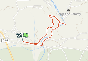
11,1 km | 17,8 km-effort
4h 0min
![](https://static1.geolcdn.com/siteimages/upload/files/16400158638029165_repeat_loop_refresh_sync_direction_icon.png)
Ja
![Tour Wandern Tourves - SityTrail - Tourves- Le Saut du Cabri - Les gorges du Caramy - Photo](https://media.geolcdn.com/t/375/260/124cbbf2-932c-4737-ad3d-4f1fc25db1d8.jpg&format=jpg&maxdim=2)
![Wandern Wandern](https://static1.geolcdn.com/sitytour/trail-icons/101.png)
SityTrail - Tourves- Le Saut du Cabri - Les gorges du Caramy
Wandern
Medium
(1)
Tourves,
Provence-Alpes-Côte d'Azur,
Var,
France
![](/images/other/stat-length.png)
12,6 km | 17,6 km-effort
6h 0min
![](https://static1.geolcdn.com/siteimages/upload/files/16400158638029165_repeat_loop_refresh_sync_direction_icon.png)
Ja
![Tour Wandern La Roquebrussanne - La Roquebrussane trace réelle - Photo](https://media.geolcdn.com/t/375/260/bd781b01-e02d-463a-9f6d-1b6e26db8323.jpg&format=jpg&maxdim=2)
![Wandern Wandern](https://static1.geolcdn.com/sitytour/trail-icons/101.png)
La Roquebrussane trace réelle
Wandern
Sehr schwierig
La Roquebrussanne,
Provence-Alpes-Côte d'Azur,
Var,
France
![](/images/other/stat-length.png)
19,9 km | 32 km-effort
7h 12min
![](https://static1.geolcdn.com/siteimages/upload/files/16400158638029165_repeat_loop_refresh_sync_direction_icon.png)
Ja
![Tour Wandern La Roquebrussanne - SityTrail - 2718180 - baume-fere-font-coulette-croix-de-berard - Photo](https://media.geolcdn.com/t/375/260/c19c381a-d852-4d85-81bc-d0bf63742810.jpg&format=jpg&maxdim=2)
![Wandern Wandern](https://static1.geolcdn.com/sitytour/trail-icons/101.png)
SityTrail - 2718180 - baume-fere-font-coulette-croix-de-berard
Wandern
Medium
La Roquebrussanne,
Provence-Alpes-Côte d'Azur,
Var,
France
![](/images/other/stat-length.png)
14,4 km | 22 km-effort
6h 0min
![](https://static1.geolcdn.com/siteimages/upload/files/16400158638029165_repeat_loop_refresh_sync_direction_icon.png)
Ja
![Tour Wandern Mazaugues - le Mourre d'Agnis au départ du Caucadis - Photo](https://media.geolcdn.com/t/375/260/dcd1794e-c5af-44e1-af91-1fadcb296c68.jpg&format=jpg&maxdim=2)
![Wandern Wandern](https://static1.geolcdn.com/sitytour/trail-icons/101.png)
le Mourre d'Agnis au départ du Caucadis
Wandern
Schwierig
Mazaugues,
Provence-Alpes-Côte d'Azur,
Var,
France
![](/images/other/stat-length.png)
17,6 km | 27 km-effort
7h 8min
![](https://static1.geolcdn.com/siteimages/upload/files/16400158638029165_repeat_loop_refresh_sync_direction_icon.png)
Ja
![Tour Wandern Mazaugues - Mazaugues le vallon de l'Herbette - Photo](https://media.geolcdn.com/t/375/260/62c4707c-a050-47d0-822e-64a046e156e1.jpg&format=jpg&maxdim=2)
![Wandern Wandern](https://static1.geolcdn.com/sitytour/trail-icons/101.png)
Mazaugues le vallon de l'Herbette
Wandern
Medium
(2)
Mazaugues,
Provence-Alpes-Côte d'Azur,
Var,
France
![](/images/other/stat-length.png)
12,2 km | 18,8 km-effort
7h 27min
![](https://static1.geolcdn.com/siteimages/upload/files/16400158638029165_repeat_loop_refresh_sync_direction_icon.png)
Ja
![Tour Wandern La Roquebrussanne - la montagne de la Loube - Photo](https://media.geolcdn.com/t/375/260/ba5f3ad3-4eed-4285-a8f8-9cedf60e39f2.jpg&format=jpg&maxdim=2)
![Wandern Wandern](https://static1.geolcdn.com/sitytour/trail-icons/101.png)
la montagne de la Loube
Wandern
Medium
La Roquebrussanne,
Provence-Alpes-Côte d'Azur,
Var,
France
![](/images/other/stat-length.png)
13,5 km | 21 km-effort
5h 30min
![](https://static1.geolcdn.com/siteimages/upload/files/16400158638029165_repeat_loop_refresh_sync_direction_icon.png)
Ja
![Tour Wandern Tourves - chapelle Saint Probace et gorges du caramy - Photo](https://media.geolcdn.com/t/375/260/ext.jpg?maxdim=2&url=https%3A%2F%2Fservices.sitytrail.com%2FGeolivesWS%2FDownloadMedia.ashx%3FTrailID%3D984279%26Media%3Dfix__20180610150603.jpg)
![Wandern Wandern](https://static1.geolcdn.com/sitytour/trail-icons/101.png)
chapelle Saint Probace et gorges du caramy
Wandern
Einfach
Tourves,
Provence-Alpes-Côte d'Azur,
Var,
France
![](/images/other/stat-length.png)
7,7 km | 11,2 km-effort
3h 26min
![](https://static1.geolcdn.com/siteimages/upload/files/16400158638029165_repeat_loop_refresh_sync_direction_icon.png)
Ja
![Tour Wandern La Roquebrussanne - La Roquebrussane-Jas du murier - Photo](https://media.geolcdn.com/t/375/260/ext.jpg?maxdim=2&url=https%3A%2F%2Fstatic1.geolcdn.com%2Fsiteimages%2Fupload%2Ffiles%2F1553511878bg_sport_marche.png)
![Wandern Wandern](https://static1.geolcdn.com/sitytour/trail-icons/101.png)
La Roquebrussane-Jas du murier
Wandern
Medium
(1)
La Roquebrussanne,
Provence-Alpes-Côte d'Azur,
Var,
France
![](/images/other/stat-length.png)
18,4 km | 25 km-effort
5h 21min
![](https://static1.geolcdn.com/siteimages/upload/files/16400158638029165_repeat_loop_refresh_sync_direction_icon.png)
Ja