![](/images/other/stat-length.png)
![Tour Mountainbike Chambéry - activity_5254224482 - Photo](https://media.geolcdn.com/t/1900/400/ext.pjpeg?maxdim=2&url=https%3A%2F%2Fstatic1.geolcdn.com%2Fsiteimages%2Fupload%2Ffiles%2F1524743154velo.jpg)
activity_5254224482
Uio73
Benutzer
![Länge](/images/other/stat-length.png)
Länge
26 km
![Maximale Höhe](https://static1.geolcdn.com/siteimages/upload/files/1508320355ic_sort_altitude_max_24dp.png)
Maximale Höhe
1180 m
![Positive Höhendifferenz](https://static1.geolcdn.com/siteimages/upload/files/1508320355ic_sort_den_pos_24dp.png)
Positive Höhendifferenz
976 m
![Km-Effort](/images/other/stat-length.png)
Km-Effort
39 km
![Min. Höhe](https://static1.geolcdn.com/siteimages/upload/files/1508320355ic_sort_altitude_min_24dp.png)
Min. Höhe
273 m
![Negative Höhendifferenz](https://static1.geolcdn.com/siteimages/upload/files/1508320355ic_sort_den_neg_24dp.png)
Negative Höhendifferenz
976 m
![Boucle](https://static1.geolcdn.com/siteimages/upload/files/16400158638029165_repeat_loop_refresh_sync_direction_icon.png)
Boucle
Ja
Erstellungsdatum :
2021-05-29 08:07:13.682
Letzte Änderung :
2021-05-29 08:11:25.725
![Mountainbike](https://static1.geolcdn.com/sitytour/trail-icons/202.png)
--
Schwierigkeit : Medium
![Scannen Sie diesen QR-Code, um die Tour in der SityTrail-Anwendung zu öffnen](https://capi.geolives.com/qq0zvz2zws4bq2lad0pu/sitytour/trails/2805862/qr.png?size=200)
Kostenlosegpshiking-Anwendung
Über SityTrail
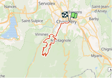
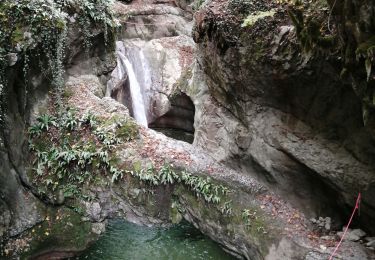
Tour Mountainbike von 26 km verfügbar auf Auvergne-Rhone-Alpen, Savoyen, Chambéry. Diese Tour wird von Uio73 vorgeschlagen.
Beschreibung
Tour sur le Corbeley en passant pas St Cassin. Descente pas très agréable en semi rigide car très caillouteuse au début.
Ort
Land:
France
Region :
Auvergne-Rhone-Alpen
Abteilung/Provinz :
Savoyen
Kommune :
Chambéry
Standort:
Unknown
Gehen Sie:(Dec)
Gehen Sie:(UTM)
728448 ; 5049888 (31T) N.
Kommentare
Touren in der Umgebung
![Tour Wandern Challes-les-Eaux - Le Mont Saint-Michel 895 m, depuis Challes-les-Eaux - Photo](https://media.geolcdn.com/t/375/260/ext.jpg?maxdim=2&url=https%3A%2F%2Fservices.sitytrail.com%2FGeolivesWS%2FDownloadMedia.ashx%3FTrailID%3D191627%26Media%3D15268_1.jpg)
![Wandern Wandern](https://static1.geolcdn.com/sitytour/trail-icons/101.png)
Le Mont Saint-Michel 895 m, depuis Challes-les-Eaux
Wandern
Schwierig
(1)
Challes-les-Eaux,
Auvergne-Rhone-Alpen,
Savoyen,
France
![](/images/other/stat-length.png)
7,6 km | 15 km-effort
4h 15min
![](https://static1.geolcdn.com/siteimages/upload/files/16400158638029165_repeat_loop_refresh_sync_direction_icon.png)
Ja
![Tour Mountainbike Bassens - Pragondra - Photo](https://media.geolcdn.com/t/375/260/ext.jpg?maxdim=2&url=https%3A%2F%2Fservices.sitytrail.com%2FGeolivesWS%2FDownloadMedia.ashx%3FTrailID%3D147927%26Media%3D20120818110710.jpg)
![Mountainbike Mountainbike](https://static1.geolcdn.com/sitytour/trail-icons/202.png)
Pragondra
Mountainbike
Sehr leicht
(1)
Bassens,
Auvergne-Rhone-Alpen,
Savoyen,
France
![](/images/other/stat-length.png)
24 km | 34 km-effort
2h 49min
![](https://static1.geolcdn.com/siteimages/upload/files/16400158638029165_repeat_loop_refresh_sync_direction_icon.png)
Nein
![Tour Mountainbike Cognin - Autour du Corbeley - Photo](https://media.geolcdn.com/t/375/260/ext.jpg?maxdim=2&url=https%3A%2F%2Fstatic1.geolcdn.com%2Fsiteimages%2Fupload%2Ffiles%2F1524743154velo.jpg)
![Mountainbike Mountainbike](https://static1.geolcdn.com/sitytour/trail-icons/202.png)
Autour du Corbeley
Mountainbike
Medium
(1)
Cognin,
Auvergne-Rhone-Alpen,
Savoyen,
France
![](/images/other/stat-length.png)
25 km | 38 km-effort
2h 23min
![](https://static1.geolcdn.com/siteimages/upload/files/16400158638029165_repeat_loop_refresh_sync_direction_icon.png)
Ja
![Tour Wandern Saint-Alban-Leysse - 73- Le chemin des poussettes - Photo](https://media.geolcdn.com/t/375/260/ext.jpg?maxdim=2&url=https%3A%2F%2Fstatic1.geolcdn.com%2Fsiteimages%2Fupload%2Ffiles%2F1553511878bg_sport_marche.png)
![Wandern Wandern](https://static1.geolcdn.com/sitytour/trail-icons/101.png)
73- Le chemin des poussettes
Wandern
Einfach
(1)
Saint-Alban-Leysse,
Auvergne-Rhone-Alpen,
Savoyen,
France
![](/images/other/stat-length.png)
4,9 km | 10,6 km-effort
2h 2min
![](https://static1.geolcdn.com/siteimages/upload/files/16400158638029165_repeat_loop_refresh_sync_direction_icon.png)
Ja
![Tour Mountainbike Saint-Alban-Leysse - 2012-03-24 - Malpassant+ St sat - Photo](https://media.geolcdn.com/t/375/260/ext.jpg?maxdim=2&url=https%3A%2F%2Fstatic1.geolcdn.com%2Fsiteimages%2Fupload%2Ffiles%2F1524743154velo.jpg)
![Mountainbike Mountainbike](https://static1.geolcdn.com/sitytour/trail-icons/202.png)
2012-03-24 - Malpassant+ St sat
Mountainbike
Medium
(1)
Saint-Alban-Leysse,
Auvergne-Rhone-Alpen,
Savoyen,
France
![](/images/other/stat-length.png)
27 km | 44 km-effort
3h 2min
![](https://static1.geolcdn.com/siteimages/upload/files/16400158638029165_repeat_loop_refresh_sync_direction_icon.png)
Ja
![Tour Hybrid-Bike Cognin - Chambéry jujurieux - Photo](https://media.geolcdn.com/t/375/260/718fb78c-ba3a-4f4f-9193-923a356e563d.jpg&format=jpg&maxdim=2)
![Hybrid-Bike Hybrid-Bike](https://static1.geolcdn.com/sitytour/trail-icons/203.png)
Chambéry jujurieux
Hybrid-Bike
Schwierig
Cognin,
Auvergne-Rhone-Alpen,
Savoyen,
France
![](/images/other/stat-length.png)
123 km | 143 km-effort
7h 30min
![](https://static1.geolcdn.com/siteimages/upload/files/16400158638029165_repeat_loop_refresh_sync_direction_icon.png)
Nein
![Tour Rennrad Saint-Alban-Leysse - le Revard en boucle - Photo](https://media.geolcdn.com/t/375/260/735b8540-fead-4765-b67f-15a05e0fdd24.jpg&format=jpg&maxdim=2)
![Rennrad Rennrad](https://static1.geolcdn.com/sitytour/trail-icons/201.png)
le Revard en boucle
Rennrad
Schwierig
Saint-Alban-Leysse,
Auvergne-Rhone-Alpen,
Savoyen,
France
![](/images/other/stat-length.png)
66 km | 86 km-effort
3h 45min
![](https://static1.geolcdn.com/siteimages/upload/files/16400158638029165_repeat_loop_refresh_sync_direction_icon.png)
Ja
![Tour Wandern Chambéry - Cascades de Jacob - Photo](https://media.geolcdn.com/t/375/260/e897f97f-bc4f-47ad-8cbc-412ddc550437.jpg&format=jpg&maxdim=2)
![Wandern Wandern](https://static1.geolcdn.com/sitytour/trail-icons/101.png)
Cascades de Jacob
Wandern
Einfach
Chambéry,
Auvergne-Rhone-Alpen,
Savoyen,
France
![](/images/other/stat-length.png)
10 km | 14 km-effort
2h 0min
![](https://static1.geolcdn.com/siteimages/upload/files/16400158638029165_repeat_loop_refresh_sync_direction_icon.png)
Ja
![Tour Wandern Saint-Alban-Leysse - boucle circuit de l'enfer et passerelles - Photo](https://media.geolcdn.com/t/375/260/ac2bb579-866d-4c62-88d2-7af7b2e38026.jpg&format=jpg&maxdim=2)
![Wandern Wandern](https://static1.geolcdn.com/sitytour/trail-icons/101.png)
boucle circuit de l'enfer et passerelles
Wandern
Medium
Saint-Alban-Leysse,
Auvergne-Rhone-Alpen,
Savoyen,
France
![](/images/other/stat-length.png)
12,8 km | 22 km-effort
4h 16min
![](https://static1.geolcdn.com/siteimages/upload/files/16400158638029165_repeat_loop_refresh_sync_direction_icon.png)
Ja