![](/images/other/stat-length.png)
![Tour Wandern Boisset-les-Prévanches - Boisset les Prévanches 2021 05 13_ - Photo](https://media.geolcdn.com/t/1900/400/ext.pjpeg?maxdim=2&url=https%3A%2F%2Fstatic1.geolcdn.com%2Fsiteimages%2Fupload%2Ffiles%2F1553511878bg_sport_marche.png)
Boisset les Prévanches 2021 05 13_
phiber76
Benutzer
![Länge](/images/other/stat-length.png)
Länge
20 km
![Maximale Höhe](https://static1.geolcdn.com/siteimages/upload/files/1508320355ic_sort_altitude_max_24dp.png)
Maximale Höhe
152 m
![Positive Höhendifferenz](https://static1.geolcdn.com/siteimages/upload/files/1508320355ic_sort_den_pos_24dp.png)
Positive Höhendifferenz
272 m
![Km-Effort](/images/other/stat-length.png)
Km-Effort
24 km
![Min. Höhe](https://static1.geolcdn.com/siteimages/upload/files/1508320355ic_sort_altitude_min_24dp.png)
Min. Höhe
53 m
![Negative Höhendifferenz](https://static1.geolcdn.com/siteimages/upload/files/1508320355ic_sort_den_neg_24dp.png)
Negative Höhendifferenz
271 m
![Boucle](https://static1.geolcdn.com/siteimages/upload/files/16400158638029165_repeat_loop_refresh_sync_direction_icon.png)
Boucle
Ja
Erstellungsdatum :
2021-05-13 10:29:07.122
Letzte Änderung :
2021-05-15 15:34:51.499
![Wandern](https://static1.geolcdn.com/sitytour/trail-icons/101.png)
5h01
Schwierigkeit : Medium
![Scannen Sie diesen QR-Code, um die Tour in der SityTrail-Anwendung zu öffnen](https://capi.geolives.com/qq0zvz2zws4bq2lad0pu/sitytour/trails/2785143/qr.png?size=200)
Kostenlosegpshiking-Anwendung
Über SityTrail
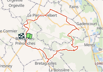
Tour Wandern von 20 km verfügbar auf Normandie, Eure, Boisset-les-Prévanches. Diese Tour wird von phiber76 vorgeschlagen.
Beschreibung
Randonnée variée
Belles maisons
Château de Prévanches à voir (de l'extérieur) absolument
Joli coin pique-nique à Bretagnolles
Sentiers majoritaires, mais un peu de goudron
Ort
Land:
France
Region :
Normandie
Abteilung/Provinz :
Eure
Kommune :
Boisset-les-Prévanches
Standort:
Unknown
Gehen Sie:(Dec)
Gehen Sie:(UTM)
377656 ; 5425233 (31U) N.
Kommentare
Touren in der Umgebung
![Tour Wandern Le Cormier - Le Cormier - Photo](https://media.geolcdn.com/t/375/260/ext.jpg?maxdim=2&url=https%3A%2F%2Fservices.sitytrail.com%2FGeolivesWS%2FDownloadMedia.ashx%3FTrailID%3D500327%26Media%3Dfix__20151206151811.jpg)
![Wandern Wandern](https://static1.geolcdn.com/sitytour/trail-icons/101.png)
Le Cormier
Wandern
Einfach
(1)
Le Cormier,
Normandie,
Eure,
France
![](/images/other/stat-length.png)
8,8 km | 10,1 km-effort
2h 1min
![](https://static1.geolcdn.com/siteimages/upload/files/16400158638029165_repeat_loop_refresh_sync_direction_icon.png)
Ja
![Tour Wandern Pacy-sur-Eure - Pacy-sur-Eure sur eure - Photo](https://media.geolcdn.com/t/375/260/ext.jpg?maxdim=2&url=https%3A%2F%2Fstatic1.geolcdn.com%2Fsiteimages%2Fupload%2Ffiles%2F1553511878bg_sport_marche.png)
![Wandern Wandern](https://static1.geolcdn.com/sitytour/trail-icons/101.png)
Pacy-sur-Eure sur eure
Wandern
Einfach
Pacy-sur-Eure,
Normandie,
Eure,
France
![](/images/other/stat-length.png)
7,9 km | 8,9 km-effort
1h 50min
![](https://static1.geolcdn.com/siteimages/upload/files/16400158638029165_repeat_loop_refresh_sync_direction_icon.png)
Ja
![Tour Wandern Caillouet-Orgeville - 2023_05_Caillouet Sud Le Plessis - Photo](https://media.geolcdn.com/t/375/260/ext.jpg?maxdim=2&url=https%3A%2F%2Fstatic1.geolcdn.com%2Fsiteimages%2Fupload%2Ffiles%2F1553511878bg_sport_marche.png)
![Wandern Wandern](https://static1.geolcdn.com/sitytour/trail-icons/101.png)
2023_05_Caillouet Sud Le Plessis
Wandern
Medium
Caillouet-Orgeville,
Normandie,
Eure,
France
![](/images/other/stat-length.png)
13,1 km | 15,3 km-effort
2h 45min
![](https://static1.geolcdn.com/siteimages/upload/files/16400158638029165_repeat_loop_refresh_sync_direction_icon.png)
Ja
![Tour Wandern Pacy-sur-Eure - voie romaine depuis salle de fetes - Photo](https://media.geolcdn.com/t/375/260/d88cd513-edff-4a33-9d03-0cc3cb6825c9.jpg&format=jpg&maxdim=2)
![Wandern Wandern](https://static1.geolcdn.com/sitytour/trail-icons/101.png)
voie romaine depuis salle de fetes
Wandern
Einfach
Pacy-sur-Eure,
Normandie,
Eure,
France
![](/images/other/stat-length.png)
10,5 km | 12 km-effort
2h 13min
![](https://static1.geolcdn.com/siteimages/upload/files/16400158638029165_repeat_loop_refresh_sync_direction_icon.png)
Ja
![Tour Wandern Pacy-sur-Eure - Croissy par le haut - Photo](https://media.geolcdn.com/t/375/260/ext.jpg?maxdim=2&url=https%3A%2F%2Fstatic1.geolcdn.com%2Fsiteimages%2Fupload%2Ffiles%2F1553511878bg_sport_marche.png)
![Wandern Wandern](https://static1.geolcdn.com/sitytour/trail-icons/101.png)
Croissy par le haut
Wandern
Einfach
Pacy-sur-Eure,
Normandie,
Eure,
France
![](/images/other/stat-length.png)
11 km | 12,6 km-effort
2h 29min
![](https://static1.geolcdn.com/siteimages/upload/files/16400158638029165_repeat_loop_refresh_sync_direction_icon.png)
Nein
![Tour Wandern Pacy-sur-Eure - la Voie Romaine. plus - Photo](https://media.geolcdn.com/t/375/260/ext.jpg?maxdim=2&url=https%3A%2F%2Fstatic1.geolcdn.com%2Fsiteimages%2Fupload%2Ffiles%2F1553511878bg_sport_marche.png)
![Wandern Wandern](https://static1.geolcdn.com/sitytour/trail-icons/101.png)
la Voie Romaine. plus
Wandern
Einfach
Pacy-sur-Eure,
Normandie,
Eure,
France
![](/images/other/stat-length.png)
10,8 km | 12,3 km-effort
2h 30min
![](https://static1.geolcdn.com/siteimages/upload/files/16400158638029165_repeat_loop_refresh_sync_direction_icon.png)
Ja
![Tour Rennrad Pacy-sur-Eure - La vallée de l’Eure - Photo](https://media.geolcdn.com/t/375/260/0adca195-af38-41b0-a628-a6ca0589082c.jpg&format=jpg&maxdim=2)
![Rennrad Rennrad](https://static1.geolcdn.com/sitytour/trail-icons/201.png)
La vallée de l’Eure
Rennrad
Einfach
Pacy-sur-Eure,
Normandie,
Eure,
France
![](/images/other/stat-length.png)
45 km | 50 km-effort
2h 11min
![](https://static1.geolcdn.com/siteimages/upload/files/16400158638029165_repeat_loop_refresh_sync_direction_icon.png)
Ja
![Tour Wandern Boisset-les-Prévanches - Boisset station - Photo](https://media.geolcdn.com/t/375/260/ext.jpg?maxdim=2&url=https%3A%2F%2Fstatic1.geolcdn.com%2Fsiteimages%2Fupload%2Ffiles%2F1553511878bg_sport_marche.png)
![Wandern Wandern](https://static1.geolcdn.com/sitytour/trail-icons/101.png)
Boisset station
Wandern
Einfach
Boisset-les-Prévanches,
Normandie,
Eure,
France
![](/images/other/stat-length.png)
9,6 km | 11,5 km-effort
2h 6min
![](https://static1.geolcdn.com/siteimages/upload/files/16400158638029165_repeat_loop_refresh_sync_direction_icon.png)
Ja
![Tour Wandern Le Plessis-Hébert - Le Plessis-hébert (SudOuest)_13.2Km - Photo](https://media.geolcdn.com/t/375/260/ext.jpg?maxdim=2&url=https%3A%2F%2Fstatic1.geolcdn.com%2Fsiteimages%2Fupload%2Ffiles%2F1553511878bg_sport_marche.png)
![Wandern Wandern](https://static1.geolcdn.com/sitytour/trail-icons/101.png)
Le Plessis-hébert (SudOuest)_13.2Km
Wandern
Medium
Le Plessis-Hébert,
Normandie,
Eure,
France
![](/images/other/stat-length.png)
13 km | 15,5 km-effort
3h 25min
![](https://static1.geolcdn.com/siteimages/upload/files/16400158638029165_repeat_loop_refresh_sync_direction_icon.png)
Ja