![](/images/other/stat-length.png)
![Tour Wandern Talmontiers - Talmontiers, Les landes - Photo](https://media.geolcdn.com/t/1900/400/7d1f6958-679a-46ce-94a5-ebb4160c2870.jpg&format=pjpeg&maxdim=2)
Talmontiers, Les landes
Marie-Claire-mcp
Benutzer
![Länge](/images/other/stat-length.png)
Länge
9,6 km
![Maximale Höhe](https://static1.geolcdn.com/siteimages/upload/files/1508320355ic_sort_altitude_max_24dp.png)
Maximale Höhe
194 m
![Positive Höhendifferenz](https://static1.geolcdn.com/siteimages/upload/files/1508320355ic_sort_den_pos_24dp.png)
Positive Höhendifferenz
222 m
![Km-Effort](/images/other/stat-length.png)
Km-Effort
12,5 km
![Min. Höhe](https://static1.geolcdn.com/siteimages/upload/files/1508320355ic_sort_altitude_min_24dp.png)
Min. Höhe
75 m
![Negative Höhendifferenz](https://static1.geolcdn.com/siteimages/upload/files/1508320355ic_sort_den_neg_24dp.png)
Negative Höhendifferenz
222 m
![Boucle](https://static1.geolcdn.com/siteimages/upload/files/16400158638029165_repeat_loop_refresh_sync_direction_icon.png)
Boucle
Ja
Erstellungsdatum :
2021-05-10 12:17:41.884
Letzte Änderung :
2021-05-10 15:34:17.9
![Wandern](https://static1.geolcdn.com/sitytour/trail-icons/101.png)
3h16
Schwierigkeit : Schwierig
![Scannen Sie diesen QR-Code, um die Tour in der SityTrail-Anwendung zu öffnen](https://capi.geolives.com/qq0zvz2zws4bq2lad0pu/sitytour/trails/2781047/qr.png?size=200)
Kostenlosegpshiking-Anwendung
Über SityTrail
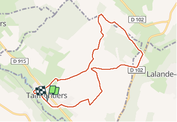
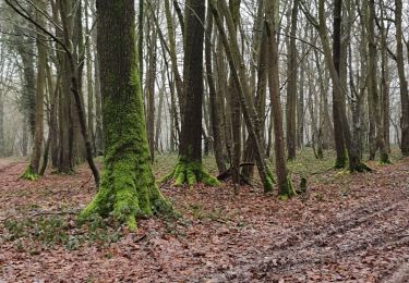
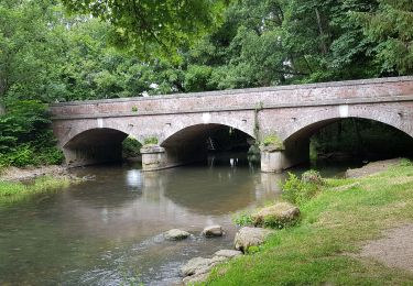
Tour Wandern von 9,6 km verfügbar auf Nordfrankreich, Oise, Talmontiers. Diese Tour wird von Marie-Claire-mcp vorgeschlagen.
Beschreibung
Départ de Talmontiers, chemin du plessis, chemin du poirier, chemin du facteur, GR , chemin des ânes, chemin Gaston Jobin, Les Landes, chemin des Galopins, rivière (Epte)
Ort
Land:
France
Region :
Nordfrankreich
Abteilung/Provinz :
Oise
Kommune :
Talmontiers
Standort:
Unknown
Gehen Sie:(Dec)
Gehen Sie:(UTM)
408408 ; 5471091 (31U) N.
Kommentare
Touren in der Umgebung
![Tour Nordic Walking Sancourt - Marche Nordique 72 Sancourt - Photo](https://media.geolcdn.com/t/375/260/ext.jpg?maxdim=2&url=https%3A%2F%2Fstatic1.geolcdn.com%2Fsiteimages%2Fupload%2Ffiles%2F1545311037marcheuse_200dpi.jpg)
![Nordic Walking Nordic Walking](https://static1.geolcdn.com/sitytour/trail-icons/102.png)
Marche Nordique 72 Sancourt
Nordic Walking
Einfach
(1)
Sancourt,
Normandie,
Eure,
France
![](/images/other/stat-length.png)
10,7 km | 12,1 km-effort
1h 30min
![](https://static1.geolcdn.com/siteimages/upload/files/16400158638029165_repeat_loop_refresh_sync_direction_icon.png)
Ja
![Tour Nordic Walking Sancourt - Marche Nordique 55 - Sancourt - Photo](https://media.geolcdn.com/t/375/260/ext.jpg?maxdim=2&url=https%3A%2F%2Fstatic1.geolcdn.com%2Fsiteimages%2Fupload%2Ffiles%2F1545311037marcheuse_200dpi.jpg)
![Nordic Walking Nordic Walking](https://static1.geolcdn.com/sitytour/trail-icons/102.png)
Marche Nordique 55 - Sancourt
Nordic Walking
Einfach
(1)
Sancourt,
Normandie,
Eure,
France
![](/images/other/stat-length.png)
8,5 km | 9,6 km-effort
Unbekannt
![](https://static1.geolcdn.com/siteimages/upload/files/16400158638029165_repeat_loop_refresh_sync_direction_icon.png)
Ja
![Tour Wandern Talmontiers - Marche Nordique 48 - Talmontiers - Photo](https://media.geolcdn.com/t/375/260/ext.jpg?maxdim=2&url=https%3A%2F%2Fstatic1.geolcdn.com%2Fsiteimages%2Fupload%2Ffiles%2F1553511878bg_sport_marche.png)
![Wandern Wandern](https://static1.geolcdn.com/sitytour/trail-icons/101.png)
Marche Nordique 48 - Talmontiers
Wandern
Einfach
(1)
Talmontiers,
Nordfrankreich,
Oise,
France
![](/images/other/stat-length.png)
8,1 km | 10,7 km-effort
2h 17min
![](https://static1.geolcdn.com/siteimages/upload/files/16400158638029165_repeat_loop_refresh_sync_direction_icon.png)
Ja
![Tour Wandern Neuf-Marché - Neufmarché - Bouchevilliers 10 - Photo](https://media.geolcdn.com/t/375/260/ext.jpg?maxdim=2&url=https%3A%2F%2Fstatic1.geolcdn.com%2Fsiteimages%2Fupload%2Ffiles%2F1553511878bg_sport_marche.png)
![Wandern Wandern](https://static1.geolcdn.com/sitytour/trail-icons/101.png)
Neufmarché - Bouchevilliers 10
Wandern
Einfach
(1)
Neuf-Marché,
Normandie,
Seine-Maritime,
France
![](/images/other/stat-length.png)
10,4 km | 12,1 km-effort
2h 41min
![](https://static1.geolcdn.com/siteimages/upload/files/16400158638029165_repeat_loop_refresh_sync_direction_icon.png)
Ja
![Tour Wandern Talmontiers - Talmontiers - Neufmarché le long de l''Epte - Photo](https://media.geolcdn.com/t/375/260/ext.jpg?maxdim=2&url=https%3A%2F%2Fstatic1.geolcdn.com%2Fsiteimages%2Fupload%2Ffiles%2F1553511878bg_sport_marche.png)
![Wandern Wandern](https://static1.geolcdn.com/sitytour/trail-icons/101.png)
Talmontiers - Neufmarché le long de l''Epte
Wandern
Einfach
(1)
Talmontiers,
Nordfrankreich,
Oise,
France
![](/images/other/stat-length.png)
12,3 km | 14,2 km-effort
3h 10min
![](https://static1.geolcdn.com/siteimages/upload/files/16400158638029165_repeat_loop_refresh_sync_direction_icon.png)
Ja
![Tour Wandern Neuf-Marché - Neufmarché à Montroty - Photo](https://media.geolcdn.com/t/375/260/91b55741-5d18-43bb-8a41-763dd3522b88.jpg&format=jpg&maxdim=2)
![Wandern Wandern](https://static1.geolcdn.com/sitytour/trail-icons/101.png)
Neufmarché à Montroty
Wandern
Medium
Neuf-Marché,
Normandie,
Seine-Maritime,
France
![](/images/other/stat-length.png)
9,4 km | 11,7 km-effort
2h 16min
![](https://static1.geolcdn.com/siteimages/upload/files/16400158638029165_repeat_loop_refresh_sync_direction_icon.png)
Ja
![Tour Wandern Talmontiers - Talmontiers - Amécourt et Guerguesalle - Photo](https://media.geolcdn.com/t/375/260/afe2ad19-57c3-42ca-a08e-f82b880bd3f9.jpg&format=jpg&maxdim=2)
![Wandern Wandern](https://static1.geolcdn.com/sitytour/trail-icons/101.png)
Talmontiers - Amécourt et Guerguesalle
Wandern
Medium
Talmontiers,
Nordfrankreich,
Oise,
France
![](/images/other/stat-length.png)
9,1 km | 11,1 km-effort
2h 34min
![](https://static1.geolcdn.com/siteimages/upload/files/16400158638029165_repeat_loop_refresh_sync_direction_icon.png)
Ja
![Tour Wandern Talmontiers - Talmontiers les Landes But David Les Binaux - Photo](https://media.geolcdn.com/t/375/260/1621c026-d58b-43d2-89e4-b72df279eaf4.jpg&format=jpg&maxdim=2)
![Wandern Wandern](https://static1.geolcdn.com/sitytour/trail-icons/101.png)
Talmontiers les Landes But David Les Binaux
Wandern
Medium
Talmontiers,
Nordfrankreich,
Oise,
France
![](/images/other/stat-length.png)
11,7 km | 14,4 km-effort
2h 47min
![](https://static1.geolcdn.com/siteimages/upload/files/16400158638029165_repeat_loop_refresh_sync_direction_icon.png)
Ja
![Tour Wandern Talmontiers - Talmontiers Amécourt Sérifontaine - Photo](https://media.geolcdn.com/t/375/260/3f94fb32-28d9-42d9-94ce-0625f9619526.jpg&format=jpg&maxdim=2)
![Wandern Wandern](https://static1.geolcdn.com/sitytour/trail-icons/101.png)
Talmontiers Amécourt Sérifontaine
Wandern
Medium
Talmontiers,
Nordfrankreich,
Oise,
France
![](/images/other/stat-length.png)
9 km | 11,1 km-effort
2h 12min
![](https://static1.geolcdn.com/siteimages/upload/files/16400158638029165_repeat_loop_refresh_sync_direction_icon.png)
Nein